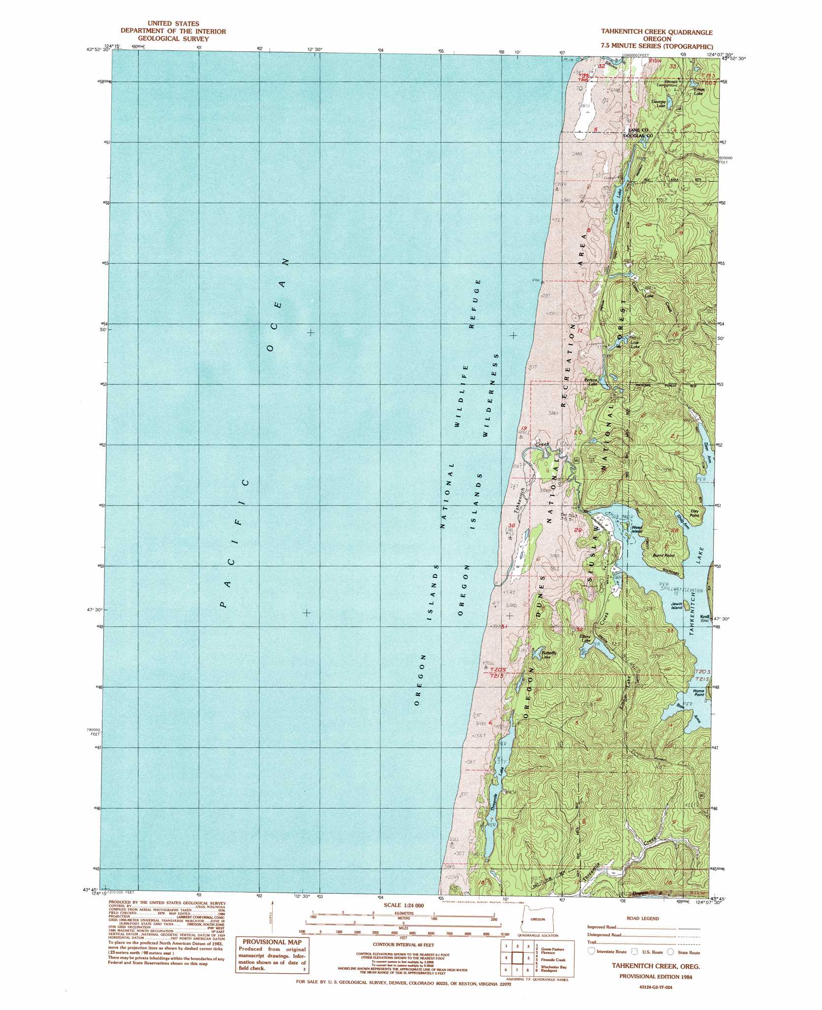
Tahkenitch Creek Topo Map Oregon
To zoom in, hover over the map of Tahkenitch Creek
USGS Topo Quad 43124g2 - 1:24,000 scale
| Topo Map Name: | Tahkenitch Creek |
| USGS Topo Quad ID: | 43124g2 |
| Print Size: | ca. 21 1/4" wide x 27" high |
| Southeast Coordinates: | 43.75° N latitude / 124.125° W longitude |
| Map Center Coordinates: | 43.8125° N latitude / 124.1875° W longitude |
| U.S. State: | OR |
| Filename: | o43124g2.jpg |
| Download Map JPG Image: | Tahkenitch Creek topo map 1:24,000 scale |
| Map Type: | Topographic |
| Topo Series: | 7.5´ |
| Map Scale: | 1:24,000 |
| Source of Map Images: | United States Geological Survey (USGS) |
| Alternate Map Versions: |
Tahkenitch Creek OR 1984, updated 1984 Download PDF Buy paper map Tahkenitch Creek OR 2011 Download PDF Buy paper map Tahkenitch Creek OR 2014 Download PDF Buy paper map |
| FStopo: | US Forest Service topo Tahkenitch Creek is available: Download FStopo PDF Download FStopo TIF |
1:24,000 Topo Quads surrounding Tahkenitch Creek
Mercer Lake |
Tiernan |
|||
Goose Pasture |
Florence |
Goodwin Peak |
||
Tahkenitch Creek |
Fivemile Creek |
North Fork |
||
Winchester Bay |
Reedsport |
Deer Head Point |
||
Lakeside |
Trail Butte |
Eck Peak |
> Back to 43124e1 at 1:100,000 scale
> Back to 43124a1 at 1:250,000 scale
> Back to U.S. Topo Maps home
Tahkenitch Creek topo map: Gazetteer
Tahkenitch Creek: Bays
Bass Arms elevation 6m 19′Deer Arm elevation 6m 19′
Shag Arm elevation 6m 19′
Tahkenitch Creek: Capes
Burnt Point elevation 6m 19′Clay Point elevation 6m 19′
Home Point elevation 6m 19′
Spring Point elevation 8m 26′
Tahkenitch Creek: Dams
Tahkenitch Lake Dam elevation 9m 29′Tahkenitch Creek: Islands
Jewitt Island elevation 26m 85′Weed Island elevation 6m 19′
Tahkenitch Creek: Lakes
Butterfly Lake elevation 25m 82′Carter Lake elevation 19m 62′
Crown Z Lake elevation 42m 137′
Elbow Lake elevation 13m 42′
Erhart Lake elevation 50m 164′
Georgia Lake elevation 50m 164′
Loon Lake elevation 36m 118′
Lost Lake elevation 45m 147′
Perkins Lake elevation 38m 124′
Tahkenitch Lake elevation 9m 29′
Threemile Lake elevation 12m 39′
Tahkenitch Creek: Post Offices
Kroll Post Office (historical) elevation 26m 85′Tahkenitch Creek: Streams
Carter Lake Creek elevation 25m 82′Elbow Lake Creek elevation 8m 26′
Siltcoos River elevation 3m 9′
Tahkenitch Creek elevation 3m 9′
Tahkenitch Creek: Trails
Carter Dunes Trail elevation 12m 39′Overlook Loop Trail elevation 2m 6′
Tahkenitch Trail elevation 114m 374′
Threemile Lake Trail elevation 86m 282′
Waxmyrtle Trail elevation 16m 52′
Tahkenitch Creek digital topo map on disk
Buy this Tahkenitch Creek topo map showing relief, roads, GPS coordinates and other geographical features, as a high-resolution digital map file on DVD: