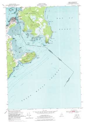
Lubec Topo Map Maine
To zoom in, hover over the map of Lubec
USGS Topo Quad 44066g8 - 1:24,000 scale
| Topo Map Name: | Lubec |
| USGS Topo Quad ID: | 44066g8 |
| Print Size: | ca. 21 1/4" wide x 27" high |
| Southeast Coordinates: | 44.75° N latitude / 66.875° W longitude |
| Map Center Coordinates: | 44.8125° N latitude / 66.9375° W longitude |
| U.S. State: | ME |
| Filename: | o44066g8.jpg |
| Download Map JPG Image: | Lubec topo map 1:24,000 scale |
| Map Type: | Topographic |
| Topo Series: | 7.5´ |
| Map Scale: | 1:24,000 |
| Source of Map Images: | United States Geological Survey (USGS) |
| Alternate Map Versions: |
Lubec ME 1949, updated 1967 Download PDF Buy paper map Lubec ME 1949, updated 1978 Download PDF Buy paper map Lubec ME 1949, updated 1978 Download PDF Buy paper map Lubec ME 1952 Download PDF Buy paper map Lubec ME 2011 Download PDF Buy paper map Lubec ME 2014 Download PDF Buy paper map |
1:24,000 Topo Quads surrounding Lubec
Red Beach |
Robbinston |
Pembroke |
Eastport |
|
Whiting |
West Lubec |
Lubec |
Cutler |
|
Moose River |
> Back to 44066e1 at 1:100,000 scale
> Back to 44066a1 at 1:250,000 scale
> Back to U.S. Topo Maps home
Lubec topo map: Gazetteer
Lubec: Bars
Gravel Bar elevation 0m 0′Middle Ground elevation 0m 0′
Morton Ledge elevation 0m 0′
Wormell Ledges elevation 0m 0′
Lubec: Bays
Carrying Place Cove elevation 0m 0′Gullivers Hole elevation 0m 0′
Quoddy Narrows elevation 0m 0′
Wallace Cove elevation 0m 0′
Lubec: Capes
Lubec Neck elevation 24m 78′Mowry Point elevation 2m 6′
West Quoddy Head elevation 45m 147′
Woodward Point elevation 6m 19′
Lubec: Channels
Lubec Channel elevation 0m 0′Lubec Narrows elevation 0m 0′
Lubec: Islands
Dudley Island elevation 13m 42′Popes Folly elevation 5m 16′
Sail Rock elevation 0m 0′
Lubec: Parks
Quoddy Head State Park elevation 14m 45′Lubec: Populated Places
Lubec elevation 9m 29′South Lubec elevation 8m 26′
Lubec digital topo map on disk
Buy this Lubec topo map showing relief, roads, GPS coordinates and other geographical features, as a high-resolution digital map file on DVD:
Maine, New Hampshire, Rhode Island & Eastern Massachusetts
Buy digital topo maps: Maine, New Hampshire, Rhode Island & Eastern Massachusetts


