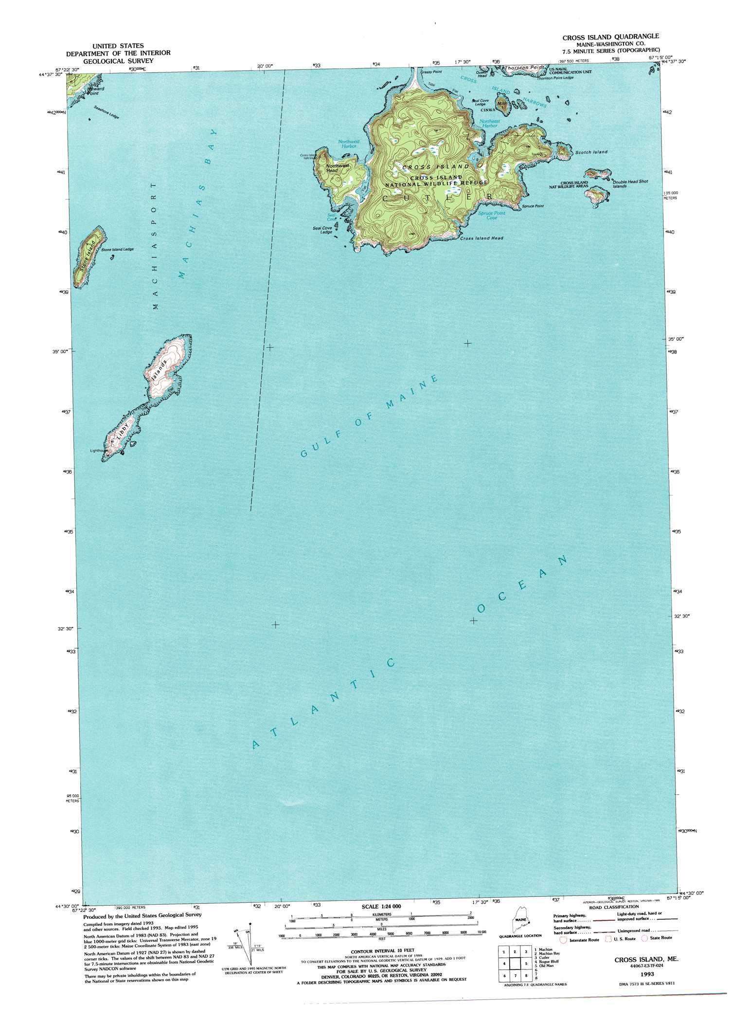
Cross Island Topo Map Maine
To zoom in, hover over the map of Cross Island
USGS Topo Quad 44067e3 - 1:24,000 scale
| Topo Map Name: | Cross Island |
| USGS Topo Quad ID: | 44067e3 |
| Print Size: | ca. 21 1/4" wide x 27" high |
| Southeast Coordinates: | 44.5° N latitude / 67.25° W longitude |
| Map Center Coordinates: | 44.5625° N latitude / 67.3125° W longitude |
| U.S. State: | ME |
| Filename: | o44067e3.jpg |
| Download Map JPG Image: | Cross Island topo map 1:24,000 scale |
| Map Type: | Topographic |
| Topo Series: | 7.5´ |
| Map Scale: | 1:24,000 |
| Source of Map Images: | United States Geological Survey (USGS) |
| Alternate Map Versions: |
Cross Island ME 1949, updated 1969 Download PDF Buy paper map Cross Island ME 1949, updated 1978 Download PDF Buy paper map Cross Island ME 1950, updated 1950 Download PDF Buy paper map Cross Island ME 1993, updated 1995 Download PDF Buy paper map Cross Island ME 2011 Download PDF Buy paper map Cross Island ME 2014 Download PDF Buy paper map |
1:24,000 Topo Quads surrounding Cross Island
Bog Lake |
Hadley Lake |
Long Lake |
Whiting |
West Lubec |
Whitneyville |
Machias |
Machias Bay |
Cutler |
Moose River |
Jonesport |
Roque Bluffs |
Cross Island |
||
Great Wass Island |
||||
> Back to 44067e1 at 1:100,000 scale
> Back to 44066a1 at 1:250,000 scale
> Back to U.S. Topo Maps home
Cross Island topo map: Gazetteer
Cross Island: Bars
Seal Cove Ledge elevation 0m 0′Seashore Ledge elevation 0m 0′
Stone Island Ledge elevation 0m 0′
Thornton Point Ledge elevation 0m 0′
Cross Island: Bays
Gulf of Maine elevation 0m 0′Northeast Harbor elevation 0m 0′
Northwest Harbor elevation 0m 0′
Seal Cove elevation 0m 0′
Spruce Point Cove elevation 0m 0′
Cross Island: Capes
Quaker Head elevation 5m 16′Spruce Point elevation 17m 55′
Thornton Point elevation 11m 36′
Cross Island: Channels
Cross Island Narrows elevation 0m 0′Cross Island: Cliffs
Cross Island Head elevation 0m 0′Cross Island: Islands
Cross Island elevation 19m 62′Double Head Shot Islands elevation 12m 39′
Libby Islands elevation 11m 36′
Mink Island elevation 25m 82′
Scotch Island elevation 16m 52′
Stone Island elevation 15m 49′
Cross Island: Parks
Cross Island National Wildlife Refuge elevation 23m 75′Cross Island: Summits
Northwest Head elevation 27m 88′Cross Island digital topo map on disk
Buy this Cross Island topo map showing relief, roads, GPS coordinates and other geographical features, as a high-resolution digital map file on DVD:
Maine, New Hampshire, Rhode Island & Eastern Massachusetts
Buy digital topo maps: Maine, New Hampshire, Rhode Island & Eastern Massachusetts