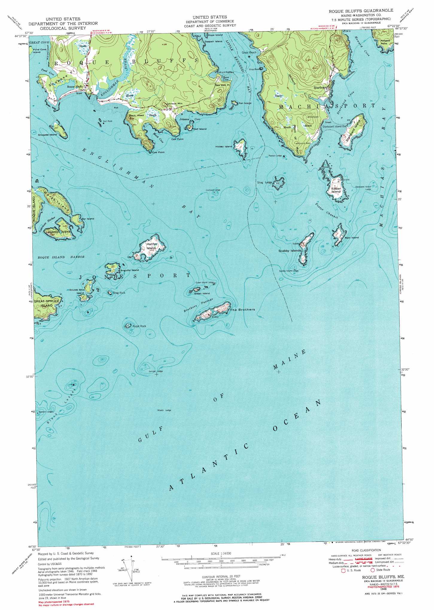
Roque Bluffs Topo Map Maine
To zoom in, hover over the map of Roque Bluffs
USGS Topo Quad 44067e4 - 1:24,000 scale
| Topo Map Name: | Roque Bluffs |
| USGS Topo Quad ID: | 44067e4 |
| Print Size: | ca. 21 1/4" wide x 27" high |
| Southeast Coordinates: | 44.5° N latitude / 67.375° W longitude |
| Map Center Coordinates: | 44.5625° N latitude / 67.4375° W longitude |
| U.S. State: | ME |
| Filename: | o44067e4.jpg |
| Download Map JPG Image: | Roque Bluffs topo map 1:24,000 scale |
| Map Type: | Topographic |
| Topo Series: | 7.5´ |
| Map Scale: | 1:24,000 |
| Source of Map Images: | United States Geological Survey (USGS) |
| Alternate Map Versions: |
Roque Bluffs ME 1948, updated 1969 Download PDF Buy paper map Roque Bluffs ME 1948, updated 1983 Download PDF Buy paper map Roque Bluffs ME 1951 Download PDF Buy paper map Roque Bluffs ME 2011 Download PDF Buy paper map Roque Bluffs ME 2014 Download PDF Buy paper map |
1:24,000 Topo Quads surrounding Roque Bluffs
Peaked Mountain Pond |
Bog Lake |
Hadley Lake |
Long Lake |
Whiting |
Columbia Falls |
Whitneyville |
Machias |
Machias Bay |
Cutler |
Addison |
Jonesport |
Roque Bluffs |
Cross Island |
|
Drisko Island |
Great Wass Island |
|||
> Back to 44067e1 at 1:100,000 scale
> Back to 44066a1 at 1:250,000 scale
> Back to U.S. Topo Maps home
Roque Bluffs topo map: Gazetteer
Roque Bluffs: Bars
Codhead Ledge elevation 0m 0′Green Island Ledge elevation 0m 0′
Jumper Ledge elevation 0m 0′
Misery Ledge elevation 0m 0′
Scabby Island Ledge elevation 0m 0′
Starboard Island Bar elevation 0m 0′
Starboard Island Ledge elevation 0m 0′
The Black Rocks elevation 0m 0′
Roque Bluffs: Bays
Bare Cove elevation 0m 0′Englishman Bay elevation 0m 0′
Howard Cove elevation 0m 0′
Johnson Cove elevation 0m 0′
Lakeman Harbor elevation 0m 0′
Mack Cove elevation 0m 0′
Pond Cove elevation 0m 0′
Starboard Cove elevation 0m 0′
Roque Bluffs: Beaches
Grays Beach elevation 0m 0′Roque Bluffs Beach elevation 5m 16′
Roque Bluffs: Capes
Calf Point elevation 6m 19′Cow Point elevation 0m 0′
Howard Point elevation 8m 26′
Point of Main elevation 30m 98′
Sea Wall Point elevation 0m 0′
Shoppee Point elevation 10m 32′
Roque Bluffs: Channels
Brothers Passage elevation 0m 0′Foster Channel elevation 0m 0′
Roque Bluffs: Islands
Anguilla Island elevation 6m 19′Bar Island elevation 9m 29′
Calf Island elevation 6m 19′
Despair Island elevation 0m 0′
Double Shot Island elevation 9m 29′
East Black Rock elevation 0m 0′
Fan Island elevation 6m 19′
Foster Island elevation 13m 42′
Grays Rock elevation 0m 0′
Green Island elevation 9m 29′
Gull Rock elevation 0m 0′
Halifax Island elevation 12m 39′
Hickey Island elevation 7m 22′
Lakeman Island elevation 6m 19′
Marsh Island elevation 19m 62′
Middle Black Rock elevation 0m 0′
Pierson Ledge elevation 0m 0′
Pulpit Rock elevation 0m 0′
Ram Island elevation 7m 22′
Scabby Islands elevation 8m 26′
Shag Ledge elevation 0m 0′
Shag Rock elevation 0m 0′
Shoppee Island elevation 9m 29′
Starboard Island elevation 9m 29′
The Biscuit elevation 0m 0′
The Brothers elevation 26m 85′
Roque Bluffs: Parks
Roque Bluffs State Park elevation 0m 0′Roque Bluffs: Populated Places
Roque Bluffs elevation 17m 55′Starboard elevation 13m 42′
Roque Bluffs: Reservoirs
Simpson Pond elevation 7m 22′Roque Bluffs: Streams
Englishman River elevation 0m 0′Starboard Creek elevation 0m 0′
Roque Bluffs: Summits
Black Head elevation 32m 104′Johnson Mountain elevation 39m 127′
Roque Bluffs digital topo map on disk
Buy this Roque Bluffs topo map showing relief, roads, GPS coordinates and other geographical features, as a high-resolution digital map file on DVD:
Maine, New Hampshire, Rhode Island & Eastern Massachusetts
Buy digital topo maps: Maine, New Hampshire, Rhode Island & Eastern Massachusetts