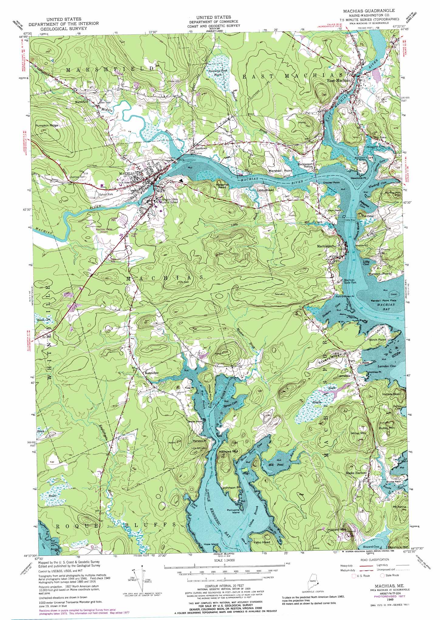
Machias Topo Map Maine
To zoom in, hover over the map of Machias
USGS Topo Quad 44067f4 - 1:24,000 scale
| Topo Map Name: | Machias |
| USGS Topo Quad ID: | 44067f4 |
| Print Size: | ca. 21 1/4" wide x 27" high |
| Southeast Coordinates: | 44.625° N latitude / 67.375° W longitude |
| Map Center Coordinates: | 44.6875° N latitude / 67.4375° W longitude |
| U.S. State: | ME |
| Filename: | o44067f4.jpg |
| Download Map JPG Image: | Machias topo map 1:24,000 scale |
| Map Type: | Topographic |
| Topo Series: | 7.5´ |
| Map Scale: | 1:24,000 |
| Source of Map Images: | United States Geological Survey (USGS) |
| Alternate Map Versions: |
Machias ME 1949, updated 1962 Download PDF Buy paper map Machias ME 1949, updated 1971 Download PDF Buy paper map Machias ME 1949, updated 1978 Download PDF Buy paper map Machias ME 1949, updated 1988 Download PDF Buy paper map Machias ME 1949, updated 1988 Download PDF Buy paper map Machias ME 1951 Download PDF Buy paper map Machias ME 2011 Download PDF Buy paper map Machias ME 2014 Download PDF Buy paper map |
1:24,000 Topo Quads surrounding Machias
Wesley |
Round Lake |
Lake Cathance |
Porcupine Mountain |
Pembroke |
Peaked Mountain Pond |
Bog Lake |
Hadley Lake |
Long Lake |
Whiting |
Columbia Falls |
Whitneyville |
Machias |
Machias Bay |
Cutler |
Addison |
Jonesport |
Roque Bluffs |
Cross Island |
|
Drisko Island |
Great Wass Island |
> Back to 44067e1 at 1:100,000 scale
> Back to 44066a1 at 1:250,000 scale
> Back to U.S. Topo Maps home
Machias topo map: Gazetteer
Machias: Airports
Machias Valley Airport elevation 27m 88′Machias: Bays
Collins Branch elevation 0m 0′Duck Cove elevation 0m 0′
East Branch Little Kennebec Bay elevation 0m 0′
Libby Cove elevation 9m 29′
Little Kennebec Bay elevation 0m 0′
Moose Snare Cove elevation 0m 0′
Petegrow Cove elevation 0m 0′
Sanborn Cove elevation 0m 0′
Shipyard Cove elevation 0m 0′
Spruce Cove elevation 0m 0′
Stevens Cove elevation 0m 0′
West Branch Little Kennebec Bay elevation 0m 0′
Woodruff Cove elevation 0m 0′
Yoho Creek elevation 0m 0′
Machias: Beaches
Jasper Beach elevation 6m 19′Machias: Capes
Birch Point elevation 11m 36′Bucks Neck elevation 11m 36′
Crocker Point elevation 12m 39′
Fort O'Brien Point elevation 7m 22′
Foss Point elevation 9m 29′
Holmes Point elevation 8m 26′
Hooper Point elevation 18m 59′
Johnson Point elevation 15m 49′
L Point elevation 0m 0′
Little Point elevation 8m 26′
Marshall Point elevation 6m 19′
Marston Point elevation 17m 55′
Newcomb Point elevation 4m 13′
Randall Point elevation 11m 36′
Smith Point elevation 8m 26′
Machias: Cliffs
The Rim elevation 4m 13′Machias: Dams
Bangor Hydro Dam elevation 8m 26′Middle River Dam elevation 0m 0′
Machias: Flats
Randall Point Flats elevation 0m 0′Machias: Islands
Hog Island elevation 1m 3′Hope Island elevation 1m 3′
Porcupine Island elevation 0m 0′
Simpson Island elevation 15m 49′
Machias: Lakes
Mill Pond elevation 1m 3′Machias: Parks
Bad Little Falls Park elevation 4m 13′East Machias Historic District elevation 12m 39′
Machias State Park elevation 13m 42′
Sylvan Park elevation 45m 147′
Machias: Populated Places
Bucks Harbor elevation 28m 91′Dog Town elevation 20m 65′
East Machias elevation 11m 36′
Hoyttown elevation 11m 36′
Kennebec elevation 7m 22′
Larrabee elevation 20m 65′
Machias elevation 25m 82′
Machiasport elevation 11m 36′
Marshfield elevation 6m 19′
Machias: Post Offices
Machias Post Office elevation 21m 68′Machias: Reservoirs
East Machias River Reservoir elevation 10m 32′Middle River Reservoir elevation 0m 0′
Machias: Ridges
Stuart Ridge elevation 63m 206′Machias: Streams
East Machias River elevation 0m 0′Libby Brook elevation 1m 3′
Machias River elevation 0m 0′
Meadow Brook elevation 0m 0′
Meadow Brook elevation 0m 0′
Middle River elevation 1m 3′
Mill Creek elevation 3m 9′
Machias: Summits
Bucks Mountain elevation 71m 232′Days Head elevation 18m 59′
Howard Mountain elevation 75m 246′
Huntley Mountain elevation 68m 223′
Indian Head elevation 52m 170′
Libby Head elevation 28m 91′
Meserve Head elevation 40m 131′
Miller Mountain elevation 76m 249′
Narrows Mountain elevation 60m 196′
Pot Head elevation 36m 118′
Pumpkin Ridge elevation 104m 341′
Seashore Mountain elevation 45m 147′
Yoho Head elevation 26m 85′
Machias: Swamps
Runaway Pond Heath elevation 14m 45′Sanborn Marsh elevation 1m 3′
Machias digital topo map on disk
Buy this Machias topo map showing relief, roads, GPS coordinates and other geographical features, as a high-resolution digital map file on DVD:
Maine, New Hampshire, Rhode Island & Eastern Massachusetts
Buy digital topo maps: Maine, New Hampshire, Rhode Island & Eastern Massachusetts