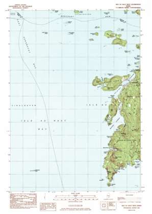
Isle Au Haut West Topo Map Maine
To zoom in, hover over the map of Isle Au Haut West
USGS Topo Quad 44068a6 - 1:24,000 scale
| Topo Map Name: | Isle Au Haut West |
| USGS Topo Quad ID: | 44068a6 |
| Print Size: | ca. 21 1/4" wide x 27" high |
| Southeast Coordinates: | 44° N latitude / 68.625° W longitude |
| Map Center Coordinates: | 44.0625° N latitude / 68.6875° W longitude |
| U.S. State: | ME |
| Filename: | o44068a6.jpg |
| Download Map JPG Image: | Isle Au Haut West topo map 1:24,000 scale |
| Map Type: | Topographic |
| Topo Series: | 7.5´ |
| Map Scale: | 1:24,000 |
| Source of Map Images: | United States Geological Survey (USGS) |
| Alternate Map Versions: |
Isle Au Haut West ME 1983, updated 1983 Download PDF Buy paper map Isle Au Haut West ME 2011 Download PDF Buy paper map Isle Au Haut West ME 2014 Download PDF Buy paper map |
1:24,000 Topo Quads surrounding Isle Au Haut West
> Back to 44068a1 at 1:100,000 scale
> Back to 44068a1 at 1:250,000 scale
> Back to U.S. Topo Maps home
Isle Au Haut West topo map: Gazetteer
Isle Au Haut West: Bars
Barter Island Ledges elevation 0m 0′Bay West elevation 0m 0′
Black Ledges elevation 0m 0′
Channel Rock elevation 0m 0′
Duck Harbor Ledge elevation 0m 0′
Flat Ledge elevation 0m 0′
George Head Ledge elevation 1m 3′
Haddock Ledge elevation 0m 0′
Harbor Island Ledge elevation 0m 0′
Keeler Rock elevation 0m 0′
Kimball Rock elevation 0m 0′
Leach Rock elevation 0m 0′
Leach Rock elevation 0m 0′
Marsh Cove Ledges elevation 0m 0′
Middle Ledges elevation 1m 3′
Moores Harbor Ledge elevation 0m 0′
Outer Scrag Ledge elevation 2m 6′
Ram Island Ledge elevation 0m 0′
Rock T elevation 0m 0′
Saddleback Ledge elevation 0m 0′
Saddleback Ledge Shoal elevation 0m 0′
Sawyer Ledge elevation 0m 0′
Sparrow Island Ledges elevation 0m 0′
The Washers elevation 0m 0′
Trial Point Ledge elevation 0m 0′
West Halibut Ledges elevation 3m 9′
West Malibu Ledges elevation 0m 0′
Isle Au Haut West: Bays
Barred Harbor elevation 0m 0′Deep Cove elevation 0m 0′
Duck Harbor elevation 3m 9′
Isle Au Haut Bay elevation 0m 0′
Laundry Cove elevation 0m 0′
Marsh Cove elevation 2m 6′
Merchants Cove elevation 1m 3′
Moores Harbor elevation 0m 0′
Northwest Cove elevation 0m 0′
Squeaker Cove elevation 7m 22′
The Seal Trap elevation 0m 0′
Isle Au Haut West: Beaches
Goss Beach elevation 3m 9′Isle Au Haut West: Capes
Birch Point elevation 3m 9′Ebens Head elevation 3m 9′
Lookout Point elevation 1m 3′
Marsh Cove Head elevation 16m 52′
Merchants Point elevation 3m 9′
Moores Head elevation 14m 45′
Robinson Point elevation 9m 29′
Sharks Point elevation 16m 52′
Trial Point elevation 3m 9′
Isle Au Haut West: Channels
Isle Au Haut Thorofare elevation 0m 0′Merchant Row elevation 0m 0′
Isle Au Haut West: Islands
Big Brewster elevation 0m 0′Bills Island elevation 10m 32′
Ewe Island elevation 3m 9′
Farrel Island elevation 8m 26′
Flake Island elevation 3m 9′
Harbor Island elevation 4m 13′
Hardwood Island elevation 16m 52′
Kimball Island elevation 43m 141′
Merchant Island elevation 34m 111′
Moxie Island elevation 3m 9′
Nathan Island elevation 5m 16′
Pell Island elevation 10m 32′
Ram Island elevation 3m 9′
Rosebud Island elevation 0m 0′
Round Island elevation 22m 72′
Scraggy Ledge elevation 0m 0′
Sparrow Island elevation 9m 29′
The Bandies elevation 0m 0′
The Brown Cow elevation 0m 0′
Western Ear Island elevation 23m 75′
Isle Au Haut West: Populated Places
Isle Au Haut elevation 15m 49′Isle Au Haut West: Streams
Merchant Brook elevation 3m 9′Isle Au Haut West: Summits
Bald Mountain elevation 47m 154′Black Dina elevation 56m 183′
Duck Harbor Mountain elevation 80m 262′
Kimball Head elevation 32m 104′
Wentworth Mountain elevation 78m 255′
Western Head elevation 36m 118′
Isle Au Haut West: Trails
Black Dina Trail elevation 45m 147′Bowditch Trail elevation 63m 206′
Cliff Trail elevation 13m 42′
Duck Harbor Trail elevation 15m 49′
Ebens Head Trail elevation 0m 0′
National Merchant Trail elevation 66m 216′
Sawyer Notch Trail elevation 46m 150′
Seal Point Trail elevation 14m 45′
Trail Point Trail elevation 13m 42′
Western Head Trail elevation 11m 36′
Isle Au Haut West digital topo map on disk
Buy this Isle Au Haut West topo map showing relief, roads, GPS coordinates and other geographical features, as a high-resolution digital map file on DVD:
Maine, New Hampshire, Rhode Island & Eastern Massachusetts
Buy digital topo maps: Maine, New Hampshire, Rhode Island & Eastern Massachusetts


