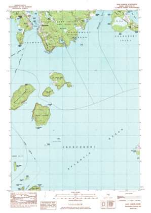
Bass Harbor Topo Map Maine
To zoom in, hover over the map of Bass Harbor
USGS Topo Quad 44068b3 - 1:24,000 scale
| Topo Map Name: | Bass Harbor |
| USGS Topo Quad ID: | 44068b3 |
| Print Size: | ca. 21 1/4" wide x 27" high |
| Southeast Coordinates: | 44.125° N latitude / 68.25° W longitude |
| Map Center Coordinates: | 44.1875° N latitude / 68.3125° W longitude |
| U.S. State: | ME |
| Filename: | o44068b3.jpg |
| Download Map JPG Image: | Bass Harbor topo map 1:24,000 scale |
| Map Type: | Topographic |
| Topo Series: | 7.5´ |
| Map Scale: | 1:24,000 |
| Source of Map Images: | United States Geological Survey (USGS) |
| Alternate Map Versions: |
Bass Harbor ME 1983, updated 1983 Download PDF Buy paper map Bass Harbor ME 2011 Download PDF Buy paper map Bass Harbor ME 2014 Download PDF Buy paper map |
1:24,000 Topo Quads surrounding Bass Harbor
> Back to 44068a1 at 1:100,000 scale
> Back to 44068a1 at 1:250,000 scale
> Back to U.S. Topo Maps home
Bass Harbor topo map: Gazetteer
Bass Harbor: Bars
Bass Harbor Bar elevation 0m 0′Beaumont Ledge elevation 0m 0′
Cranberry Island Ledge elevation 0m 0′
Crow Island Ledge elevation 0m 0′
Dry Money Ledge elevation 0m 0′
Eastern Beach Ledge elevation 0m 0′
Grindstone Ledge elevation 0m 0′
Horseshoe Ledge elevation 0m 0′
Inner Dawes Ledge elevation 0m 0′
Long Ledge elevation 0m 0′
Northeast Ledge elevation 0m 0′
Otter Ledge elevation 0m 0′
Outer Dawes Ledge elevation 0m 0′
South Bunker Ledge elevation 0m 0′
Sunken Money Ledge elevation 0m 0′
Weaver Ledge elevation 33m 108′
Bass Harbor: Bays
Bass Harbor elevation 0m 0′Bennet Cove elevation 0m 0′
Mitchell Cove elevation 0m 0′
Rich Cove elevation 0m 0′
Rum Cove elevation 0m 0′
Sea Cove elevation 0m 0′
Ship Harbor elevation 0m 0′
The Pool elevation 0m 0′
Bass Harbor: Beaches
Cobble Beach elevation 24m 78′Bass Harbor: Capes
Anns Point elevation 3m 9′Bunker Head elevation 10m 32′
Crocket Point elevation 10m 32′
Green Point elevation 12m 39′
Long Point elevation 6m 19′
Lopaus Point elevation 14m 45′
Northeast Point elevation 10m 32′
Rice Point elevation 2m 6′
Seawall Point elevation 6m 19′
Shoal Point elevation 27m 88′
Bass Harbor: Channels
Western Way elevation 0m 0′Bass Harbor: Cliffs
Bass Harbor Head elevation 21m 68′South Bunker Ledge elevation 0m 0′
Bass Harbor: Islands
Black Island elevation 40m 131′Crow Island elevation 7m 22′
Drum Island elevation 0m 0′
East Sister Island elevation 6m 19′
Great Cranberry Island elevation 9m 29′
Great Gott Island elevation 22m 72′
Green Island elevation 5m 16′
Harbor Island elevation 10m 32′
Johns Island elevation 3m 9′
Little Black Island elevation 7m 22′
Little Gott Island elevation 15m 49′
Placentia Island elevation 34m 111′
Sawyers Island elevation 1m 3′
The Drums elevation 0m 0′
Bass Harbor: Lakes
Seawall Pond elevation 2m 6′Bass Harbor: Populated Places
Baldwin Corners elevation 5m 16′Bass Harbor elevation 6m 19′
Bernard elevation 22m 72′
Cranberry Isles elevation 5m 16′
Wonderland elevation 12m 39′
Bass Harbor: Post Offices
Bass Harbor Post Office elevation 12m 39′Bernard Post Office elevation 10m 32′
Bass Harbor: Streams
Halfway Brook elevation 0m 0′Bass Harbor: Summits
Big Rocks elevation 10m 32′Bulger Hill elevation 20m 65′
Great Head elevation 17m 55′
Bass Harbor: Swamps
Bass Harbor Marsh elevation 1m 3′Big Heath elevation 8m 26′
Mitchell Marsh elevation 1m 3′
The Heath elevation 4m 13′
Bass Harbor: Trails
Harbor Trail elevation 0m 0′Wonderland Trail elevation 19m 62′
Bass Harbor digital topo map on disk
Buy this Bass Harbor topo map showing relief, roads, GPS coordinates and other geographical features, as a high-resolution digital map file on DVD:
Maine, New Hampshire, Rhode Island & Eastern Massachusetts
Buy digital topo maps: Maine, New Hampshire, Rhode Island & Eastern Massachusetts


