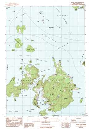
Swans Island Topo Map Maine
To zoom in, hover over the map of Swans Island
USGS Topo Quad 44068b4 - 1:24,000 scale
| Topo Map Name: | Swans Island |
| USGS Topo Quad ID: | 44068b4 |
| Print Size: | ca. 21 1/4" wide x 27" high |
| Southeast Coordinates: | 44.125° N latitude / 68.375° W longitude |
| Map Center Coordinates: | 44.1875° N latitude / 68.4375° W longitude |
| U.S. State: | ME |
| Filename: | o44068b4.jpg |
| Download Map JPG Image: | Swans Island topo map 1:24,000 scale |
| Map Type: | Topographic |
| Topo Series: | 7.5´ |
| Map Scale: | 1:24,000 |
| Source of Map Images: | United States Geological Survey (USGS) |
| Alternate Map Versions: |
Swans Island ME 1983, updated 1983 Download PDF Buy paper map Swans Island ME 2011 Download PDF Buy paper map Swans Island ME 2014 Download PDF Buy paper map |
1:24,000 Topo Quads surrounding Swans Island
> Back to 44068a1 at 1:100,000 scale
> Back to 44068a1 at 1:250,000 scale
> Back to U.S. Topo Maps home
Swans Island topo map: Gazetteer
Swans Island: Airports
Banks Airport elevation 27m 88′Swans Island: Bars
Flye Island Ledge elevation 0m 0′Gooseberry Island Ledge elevation 0m 0′
Hawley Ledge elevation 0m 0′
High Sheriff elevation 0m 0′
Long Ledge elevation 0m 0′
Sheriff Ledge elevation 0m 0′
Ship and Barges Ledge elevation 0m 0′
Sister Ledge elevation 0m 0′
Staple Ledge elevation 0m 0′
The Triangles elevation 1m 3′
Whale Ledge elevation 0m 0′
Swans Island: Bays
Back Cove elevation 0m 0′Buckle Island Harbor elevation 0m 0′
Burnt Coat Harbor elevation 0m 0′
Garden Cove elevation 0m 0′
Little House Cove elevation 1m 3′
Long Cove elevation 0m 0′
Mackerel Cove elevation 0m 0′
Sand Cove elevation 0m 0′
Sea Cove elevation 0m 0′
Southwest Cove elevation 13m 42′
Toothacher Bay elevation 0m 0′
Toothacher Cove elevation 0m 0′
Whale Cove elevation 2m 6′
Swans Island: Beaches
Hero Beach elevation 6m 19′Joyce Beach elevation 16m 52′
Sand Beach elevation 3m 9′
Swans Island: Capes
Burnt Point elevation 5m 16′City Point elevation 9m 29′
East Point elevation 13m 42′
Fir Point elevation 4m 13′
Hockamock Head elevation 25m 82′
Irish Point elevation 16m 52′
North Point elevation 8m 26′
Nutter Point elevation 14m 45′
Phinney Point elevation 14m 45′
Red Point elevation 20m 65′
Roderick Head elevation 19m 62′
Sea Island Cove Head elevation 24m 78′
Stanley Point elevation 23m 75′
Swans Island Head elevation 29m 95′
Swans Island: Channels
Casco Passage elevation 0m 0′Pond Island Passage elevation 0m 0′
York Narrows elevation 0m 0′
Swans Island: Cliffs
High Head elevation 21m 68′Swans Island: Islands
Asa Island elevation 5m 16′Black Island elevation 16m 52′
Buckle Island elevation 8m 26′
Channel Rock elevation 1m 3′
Crow Island elevation 3m 9′
Dog Island elevation 0m 0′
Duck Island elevation 7m 22′
Eagle Island elevation 5m 16′
East Barge elevation 3m 9′
Garden Islands elevation 2m 6′
Gooseberry Island elevation 0m 0′
Green Island elevation 1m 3′
Harbor Island elevation 22m 72′
Hen Island elevation 3m 9′
Johns Island elevation 5m 16′
Johnstons Island elevation 0m 0′
Lamp Island elevation 2m 6′
Opechee Island elevation 12m 39′
Orono Island elevation 19m 62′
Parks Island elevation 0m 0′
Pond Island elevation 17m 55′
Ram Island elevation 8m 26′
Round Island elevation 10m 32′
Sand Beach Ledge elevation 0m 0′
Sheep Island elevation 9m 29′
Ship Island elevation 8m 26′
Sister Islands elevation 11m 36′
Stony Island elevation 0m 0′
Swans Island elevation 41m 134′
The Hubs elevation 0m 0′
Trumpet Island elevation 3m 9′
West Barge elevation 3m 9′
West Sister Island elevation 20m 65′
Swans Island: Lakes
Goose Pond elevation 28m 91′Otter Ponds elevation 4m 13′
Quarry Pond elevation 19m 62′
Stockbridge Pond elevation 23m 75′
Swans Island: Populated Places
Atlantic elevation 14m 45′Minturn elevation 0m 0′
Richtown elevation 3m 9′
Swans Island elevation 24m 78′
Swans Island: Post Offices
Swans Island Post Office elevation 28m 91′Swans Island: Summits
Big Mountain elevation 65m 213′Goose Pond Mountain elevation 74m 242′
Stockbridge Hill elevation 53m 173′
Swans Island: Swamps
Lily Pond elevation 19m 62′Swans Island digital topo map on disk
Buy this Swans Island topo map showing relief, roads, GPS coordinates and other geographical features, as a high-resolution digital map file on DVD:
Maine, New Hampshire, Rhode Island & Eastern Massachusetts
Buy digital topo maps: Maine, New Hampshire, Rhode Island & Eastern Massachusetts


