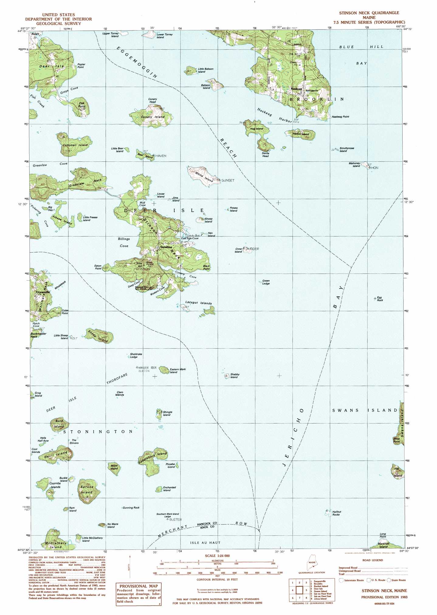
Stinson Neck Topo Map Maine
To zoom in, hover over the map of Stinson Neck
USGS Topo Quad 44068b5 - 1:24,000 scale
| Topo Map Name: | Stinson Neck |
| USGS Topo Quad ID: | 44068b5 |
| Print Size: | ca. 21 1/4" wide x 27" high |
| Southeast Coordinates: | 44.125° N latitude / 68.5° W longitude |
| Map Center Coordinates: | 44.1875° N latitude / 68.5625° W longitude |
| U.S. State: | ME |
| Filename: | o44068b5.jpg |
| Download Map JPG Image: | Stinson Neck topo map 1:24,000 scale |
| Map Type: | Topographic |
| Topo Series: | 7.5´ |
| Map Scale: | 1:24,000 |
| Source of Map Images: | United States Geological Survey (USGS) |
| Alternate Map Versions: |
Stinson Neck ME 1983, updated 1983 Download PDF Buy paper map Stinson Neck ME 2011 Download PDF Buy paper map Stinson Neck ME 2014 Download PDF Buy paper map |
1:24,000 Topo Quads surrounding Stinson Neck
Castine |
Penobscot |
Blue Hill |
Newbury Neck |
Salsbury Cove |
Cape Rosier |
Sargentville |
Brooklin |
Bartlett Island |
Southwest Harbor |
North Haven East |
Deer Isle |
Stinson Neck |
Swans Island |
Bass Harbor |
Vinalhaven |
Isle Au Haut West |
Isle Au Haut East |
Johns Island |
Frenchboro |
> Back to 44068a1 at 1:100,000 scale
> Back to 44068a1 at 1:250,000 scale
> Back to U.S. Topo Maps home
Stinson Neck topo map: Gazetteer
Stinson Neck: Bars
Bold Island Ledges elevation 0m 0′Buckmaster Ledge elevation 0m 0′
Channel Rock elevation 0m 0′
Conary Ledge elevation 0m 0′
Door Lege elevation 0m 0′
East Mark Island Ledge elevation 0m 0′
Egg Rock elevation 0m 0′
Green Ledge elevation 0m 0′
Gunning Rock elevation 0m 0′
Halibut Rocks elevation 2m 6′
Hanus Ledge elevation 0m 0′
Haskell Ledge elevation 0m 0′
Hat Island Ledge elevation 0m 0′
Hay Ledge elevation 0m 0′
Haycock Rock elevation 0m 0′
Hells Half Acre elevation 0m 0′
Lazygut Ledge elevation 0m 0′
Long Ledge elevation 0m 0′
Mahoney Ledge elevation 0m 0′
Potato Ledge elevation 0m 0′
Rudder Rock elevation 0m 0′
Sheep Island Ledge elevation 0m 0′
Sheep Rock elevation 0m 0′
Sheldrake Ledge elevation 0m 0′
Sunken Egg Rock elevation 0m 0′
The Boulders elevation 0m 0′
The Shivers elevation 1m 3′
The Triangles elevation 0m 0′
The Woodbury elevation 0m 0′
West Halibut Rock elevation 0m 0′
Whaleback Ledge elevation 0m 0′
Stinson Neck: Bays
Billings Cove elevation 0m 0′Conary Cove elevation 0m 0′
Deep Cove elevation 0m 0′
East Side Cove elevation 0m 0′
Gray Cove elevation 0m 0′
Jericho Bay elevation 0m 0′
Mud Cove elevation 0m 0′
Naskeag Harbor elevation 0m 0′
Pickering Cove elevation 0m 0′
Southern Cove elevation 0m 0′
Western Cove elevation 0m 0′
Stinson Neck: Capes
Black Point elevation 6m 19′Coles Point elevation 7m 22′
Devils Head elevation 13m 42′
Eaton Point elevation 3m 9′
Greenlaw Neck elevation 16m 52′
Long Point elevation 7m 22′
Naskeag Point elevation 1m 3′
Oak Point elevation 16m 52′
Poplar Point elevation 4m 13′
West Point elevation 15m 49′
Stinson Neck: Channels
Deer Island Thorofare elevation 0m 0′Stinson Neck: Islands
Babson Island elevation 11m 36′Bear Island elevation 3m 9′
Big Hay Island elevation 0m 0′
Bold Island elevation 23m 75′
Buckle Island elevation 3m 9′
Campbell Island elevation 9m 29′
Clam Island elevation 0m 0′
Conary Island elevation 12m 39′
Coombs Islands elevation 10m 32′
Coot Islands elevation 0m 0′
Crow Island elevation 0m 0′
Devil Island elevation 26m 85′
Eastern Mark Island elevation 0m 0′
Enchanted Island elevation 6m 19′
Freese Island elevation 18m 59′
Grog Island elevation 3m 9′
Harbor Island elevation 17m 55′
Hat Island elevation 23m 75′
Hen Island elevation 0m 0′
Hog Island elevation 7m 22′
Jims Island elevation 0m 0′
Lazygut Island elevation 5m 16′
Little Babson Island elevation 6m 19′
Little Bear Island elevation 0m 0′
Little Freese Island elevation 2m 6′
Little McGlathery Island elevation 10m 32′
Little Sheep Island elevation 0m 0′
Louse Island elevation 0m 0′
Lower Torrey Island elevation 7m 22′
Mahoney Island elevation 4m 13′
Millet Island elevation 13m 42′
No Mans Island elevation 2m 6′
Phoebe Island elevation 2m 6′
Potato Island elevation 0m 0′
Ram Island elevation 0m 0′
Saddleback Island elevation 9m 29′
Sellers Island elevation 5m 16′
Shabby Island elevation 2m 6′
Sheep Island elevation 0m 0′
Sheep Island elevation 0m 0′
Sheldrake Ledge elevation 1m 3′
Shingle Island elevation 10m 32′
Smuttynose Island elevation 0m 0′
Southern Mark Island elevation 0m 0′
Spruce Island elevation 21m 68′
Stinson Neck elevation 22m 72′
White Island elevation 13m 42′
Stinson Neck: Populated Places
Naskeag elevation 37m 121′Oceanville elevation 30m 98′
Reach elevation 9m 29′
Sunshine elevation 30m 98′
Stinson Neck: Streams
Fish Creek elevation 0m 0′Stinson Neck: Summits
Conary Head elevation 18m 59′Jims Hill elevation 28m 91′
Stinson Neck digital topo map on disk
Buy this Stinson Neck topo map showing relief, roads, GPS coordinates and other geographical features, as a high-resolution digital map file on DVD:
Maine, New Hampshire, Rhode Island & Eastern Massachusetts
Buy digital topo maps: Maine, New Hampshire, Rhode Island & Eastern Massachusetts