Deer Isle Topo Map Maine
To zoom in, hover over the map of Deer Isle
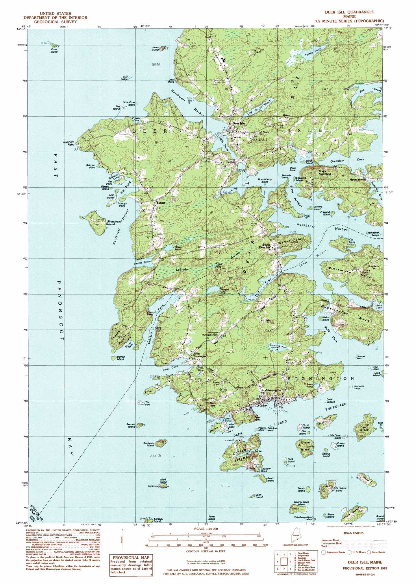
USGS Topo Quad 44068b6 - 1:24,000 scale
| Topo Map Name: | Deer Isle |
| USGS Topo Quad ID: | 44068b6 |
| Print Size: | ca. 21 1/4" wide x 27" high |
| Southeast Coordinates: | 44.125° N latitude / 68.625° W longitude |
| Map Center Coordinates: | 44.1875° N latitude / 68.6875° W longitude |
| U.S. State: | ME |
| Filename: | o44068b6.jpg |
| Download Map JPG Image: | Deer Isle topo map 1:24,000 scale |
| Map Type: | Topographic |
| Topo Series: | 7.5´ |
| Map Scale: | 1:24,000 |
| Source of Map Images: | United States Geological Survey (USGS) |
| Alternate Map Versions: |
Deer Isle ME 1983, updated 1983 Download PDF Buy paper map Deer Isle ME 2011 Download PDF Buy paper map Deer Isle ME 2014 Download PDF Buy paper map |
1:24,000 Topo Quads surrounding Deer Isle
Searsport |
Castine |
Penobscot |
Blue Hill |
Newbury Neck |
Islesboro |
Cape Rosier |
Sargentville |
Brooklin |
Bartlett Island |
North Haven West |
North Haven East |
Deer Isle |
Stinson Neck |
Swans Island |
Leadbetter Island |
Vinalhaven |
Isle Au Haut West |
Isle Au Haut East |
Johns Island |
> Back to 44068a1 at 1:100,000 scale
> Back to 44068a1 at 1:250,000 scale
> Back to U.S. Topo Maps home
Deer Isle topo map: Gazetteer
Deer Isle: Airports
Stonington Municipal Airport elevation 9m 29′Deer Isle: Bars
Barred Island Ledge elevation 0m 0′Bay Ledge elevation 0m 0′
Dow Ledge elevation 0m 0′
Dunham Point Ledge elevation 3m 9′
Grog Ledge elevation 0m 0′
Gull Ledge elevation 2m 6′
Roebuck Ledge elevation 0m 0′
Sam Stick Ledge elevation 0m 0′
Setters Rock elevation 0m 0′
Sheephead Island Ledge elevation 0m 0′
Toothacher Ledge elevation 0m 0′
Twin Ledges elevation 0m 0′
West Mark Island Ledge elevation 0m 0′
Western Deer Island Ledge elevation 0m 0′
Yellow Rock elevation 0m 0′
Deer Isle: Bays
Allen Cove elevation 0m 0′Burnt Cove elevation 0m 0′
Cat Cove elevation 0m 0′
Crockett Cove elevation 0m 0′
Deep Hole elevation 0m 0′
East Penobscot Bay elevation 0m 0′
Goose Cove elevation 0m 0′
Greenlaw Cove elevation 0m 0′
Long Cove elevation 0m 0′
Mill Cove elevation 0m 0′
Mill Pond elevation 0m 0′
Pressey Cove elevation 0m 0′
Smalls Cove elevation 36m 118′
Southwest Harbor elevation 0m 0′
Sylvester Cove elevation 0m 0′
Webb Cove elevation 0m 0′
Deer Isle: Capes
Buckmaster Neck elevation 40m 131′Dow Point elevation 7m 22′
Dunham Point elevation 9m 29′
Fifield Point elevation 5m 16′
Green Head elevation 27m 88′
Hitz Point elevation 3m 9′
Salmon Point elevation 3m 9′
Staple Point elevation 2m 6′
Thurlow Head elevation 12m 39′
Trundys Point elevation 3m 9′
Warren Point elevation 29m 95′
Deer Isle: Channels
Brays Narrows elevation 0m 0′Deer Isle: Dams
Lily Pond Dam elevation 24m 78′Deer Isle: Gaps
The Haulover elevation 4m 13′Deer Isle: Harbors
Inner Harbor elevation 0m 0′Northwest Harbor elevation 0m 0′
Southeast Harbor elevation 0m 0′
Deer Isle: Islands
Andrew Island elevation 16m 52′Bare Island elevation 17m 55′
Barred Island elevation 3m 9′
Camp Island elevation 12m 39′
Channel Rock Island elevation 0m 0′
Crotch Island elevation 6m 19′
Crow Island elevation 1m 3′
Current Island elevation 3m 9′
Deer Isle elevation 23m 75′
Flat Island elevation 3m 9′
Flea Island elevation 0m 0′
George Head Island elevation 4m 13′
Green Island elevation 16m 52′
Heart Island elevation 22m 72′
Huckleberry Island elevation 1m 3′
Humpkins Island elevation 0m 0′
John Island elevation 0m 0′
Kiahs Island elevation 5m 16′
Little Camp Island elevation 1m 3′
Little Crow Island elevation 0m 0′
Little George Head Island elevation 0m 0′
Mark Island elevation 7m 22′
Mill Island elevation 3m 9′
Moose Island elevation 4m 13′
Peggys Island elevation 1m 3′
Pigeon Island elevation 0m 0′
Polypod Island elevation 6m 19′
Potato Island elevation 6m 19′
Potato Island elevation 4m 13′
Rabbit Island elevation 3m 9′
Rock Island elevation 4m 13′
Russ Island elevation 27m 88′
Saint Helena Island elevation 23m 75′
Sams Island elevation 2m 6′
Sand Island elevation 12m 39′
Sawyers Island elevation 3m 9′
Scott Island elevation 11m 36′
Scraggy Island elevation 9m 29′
Second Island elevation 10m 32′
Sheephead Island elevation 12m 39′
Sprout Island elevation 0m 0′
Steve Island elevation 0m 0′
Teakettle Island elevation 0m 0′
The Fort elevation 5m 16′
Two Bush Island elevation 0m 0′
Whig Island elevation 2m 6′
Whitmore Neck elevation 43m 141′
Wreck Island elevation 15m 49′
Deer Isle: Lakes
Ames Pond elevation 6m 19′Burntland Pond elevation 18m 59′
Georges Pond elevation 3m 9′
Holt Pond elevation 2m 6′
Mill Pond elevation 0m 0′
Olivers Pond elevation 7m 22′
Toffet Pond elevation 4m 13′
Torrey Pond elevation 21m 68′
Deer Isle: Mines
John L Goss Quarry (historical) elevation 29m 95′Settlement Quarry elevation 34m 111′
Deer Isle: Parks
Barred Island Preserve elevation 3m 9′Crockett Cove Woods Preserve elevation 19m 62′
Deer Isle: Populated Places
Deer Isle elevation 12m 39′Mountainville elevation 6m 19′
South Deer Isle elevation 23m 75′
Stonington elevation 22m 72′
Sunset elevation 27m 88′
West Deer Isle elevation 11m 36′
West Stonington elevation 5m 16′
Deer Isle: Reservoirs
Lily Pond elevation 24m 78′Deer Isle: Summits
Brays Mountain elevation 46m 150′Burnt Hill elevation 35m 114′
Stinson Point elevation 37m 121′
Deer Isle: Swamps
Labrador Swamp elevation 5m 16′Deer Isle: Woods
Crockett Cove Woods elevation 30m 98′Deer Isle digital topo map on disk
Buy this Deer Isle topo map showing relief, roads, GPS coordinates and other geographical features, as a high-resolution digital map file on DVD:
Maine, New Hampshire, Rhode Island & Eastern Massachusetts
Buy digital topo maps: Maine, New Hampshire, Rhode Island & Eastern Massachusetts