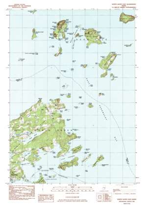
North Haven East Topo Map Maine
To zoom in, hover over the map of North Haven East
USGS Topo Quad 44068b7 - 1:24,000 scale
| Topo Map Name: | North Haven East |
| USGS Topo Quad ID: | 44068b7 |
| Print Size: | ca. 21 1/4" wide x 27" high |
| Southeast Coordinates: | 44.125° N latitude / 68.75° W longitude |
| Map Center Coordinates: | 44.1875° N latitude / 68.8125° W longitude |
| U.S. State: | ME |
| Filename: | o44068b7.jpg |
| Download Map JPG Image: | North Haven East topo map 1:24,000 scale |
| Map Type: | Topographic |
| Topo Series: | 7.5´ |
| Map Scale: | 1:24,000 |
| Source of Map Images: | United States Geological Survey (USGS) |
| Alternate Map Versions: |
North Haven East ME 1982, updated 1983 Download PDF Buy paper map North Haven East ME 2011 Download PDF Buy paper map North Haven East ME 2014 Download PDF Buy paper map |
1:24,000 Topo Quads surrounding North Haven East
> Back to 44068a1 at 1:100,000 scale
> Back to 44068a1 at 1:250,000 scale
> Back to U.S. Topo Maps home
North Haven East topo map: Gazetteer
North Haven East: Airports
Watson Airport elevation 30m 98′Watson Landing Strip elevation 32m 104′
North Haven East: Bars
Babbidge Island Ledges elevation 2m 6′Black Ledge elevation 0m 0′
Bradstreet Rock elevation 0m 0′
Compass Island Ledge elevation 0m 0′
Dagger Ledge elevation 0m 0′
Dobbin Rock elevation 0m 0′
Fish Point Ledge elevation 20m 65′
Grass Ledge elevation 0m 0′
Grass Ledge elevation 0m 0′
Kent Ledge elevation 0m 0′
Lobster Ledge elevation 0m 0′
Middle Rock elevation 0m 0′
Pond Hole Ledges elevation 1m 3′
Post Office Ledge elevation 0m 0′
Sloop Island Ledge elevation 0m 0′
Spoon Ledge elevation 0m 0′
Stimpsons Rock elevation 0m 0′
Sunken Black Ledge elevation 0m 0′
Waterman Ledge elevation 0m 0′
North Haven East: Bays
Armstrong Cove elevation 0m 0′Banks Cove elevation 0m 0′
Cubby Hole elevation 3m 9′
Kent Cove elevation 0m 0′
Marsh Cove elevation 0m 0′
Mill Stream elevation 11m 36′
Mullen Cove elevation 0m 0′
The Wood Land elevation 0m 0′
Waterman Cove elevation 0m 0′
North Haven East: Beaches
Bear Island Beach elevation 3m 9′Brook Beach elevation 0m 0′
Double Beach elevation 0m 0′
Driftwood Beach elevation 6m 19′
Harbor Beach elevation 4m 13′
Lighthouse Beach elevation 5m 16′
North Point Beach elevation 2m 6′
Orchard Beach elevation 3m 9′
Steep Bank Beach elevation 23m 75′
The Brook Beach elevation 3m 9′
Three Island Beach elevation 3m 9′
Walton Beach elevation 4m 13′
North Haven East: Capes
Birch Point elevation 6m 19′Calderwood Point elevation 5m 16′
Fish Point elevation 7m 22′
Fish Point elevation 15m 49′
Indian Point elevation 0m 0′
Iron Point elevation 3m 9′
Long Point elevation 7m 22′
Mullen Head elevation 22m 72′
North Point elevation 33m 108′
Salt Point elevation 7m 22′
South Point elevation 1m 3′
The Nubble elevation 3m 9′
Webster Head elevation 13m 42′
West Point elevation 12m 39′
North Haven East: Channels
Fox Islands Thorofare elevation 0m 0′Little Thorofare elevation 0m 0′
North Haven East: Islands
Babbidge Island elevation 17m 55′Bald Island elevation 18m 59′
Barred Islands elevation 0m 0′
Bear Island elevation 3m 9′
Beverage Island elevation 2m 6′
Big Barred Island elevation 14m 45′
Big Green Island elevation 0m 0′
Birch Island elevation 0m 0′
Boy Scout Island elevation 0m 0′
Bradbury Island elevation 37m 121′
Burnt Island elevation 8m 26′
Burnt Island elevation 11m 36′
Butter Island elevation 36m 118′
Calderwood Island elevation 12m 39′
Channel Rock elevation 0m 0′
Compass Island elevation 0m 0′
Dagger Island elevation 0m 0′
Downfall Island elevation 0m 0′
Eagle Island elevation 28m 91′
Fling Island elevation 16m 52′
Great Spruce Head Island elevation 18m 59′
Hardhead Island elevation 21m 68′
Hog Island elevation 0m 0′
Horsehead Island elevation 10m 32′
Little Barred Island elevation 0m 0′
Little Green Island elevation 1m 3′
Little Spruce Head Island elevation 0m 0′
North Haven Island elevation 16m 52′
Oak Island elevation -1m -4′
Peak Island elevation 7m 22′
Pease Island elevation 1m 3′
Scrag Island elevation 0m 0′
Sheep Island elevation 19m 62′
Sloop Island elevation 0m 0′
Stimpsons Island elevation 24m 78′
The Chain Links elevation 0m 0′
The Porcupines elevation 8m 26′
The Sugarloaf elevation 3m 9′
Widow Island elevation 5m 16′
North Haven East: Lakes
Charley Browns Pond elevation 10m 32′Fresh Pond elevation 0m 0′
Salt Pond elevation 0m 0′
North Haven East: Parks
Mullen Head Park elevation 10m 32′North Haven East: Populated Places
Goose Rocks elevation 0m 0′North Haven elevation 12m 39′
North Haven East: Summits
Apple Tree Hill elevation 27m 88′Big Mountain elevation 59m 193′
Little Mountain elevation 43m 141′
Mount Nebo elevation 39m 127′
Oak Hill elevation 40m 131′
The Head elevation 67m 219′
The Nubble elevation 28m 91′
North Haven East: Swamps
Pond Swamp elevation 1m 3′Purgatory Swamp elevation 14m 45′
North Haven East digital topo map on disk
Buy this North Haven East topo map showing relief, roads, GPS coordinates and other geographical features, as a high-resolution digital map file on DVD:
Maine, New Hampshire, Rhode Island & Eastern Massachusetts
Buy digital topo maps: Maine, New Hampshire, Rhode Island & Eastern Massachusetts


