North Haven West Topo Map Maine
To zoom in, hover over the map of North Haven West
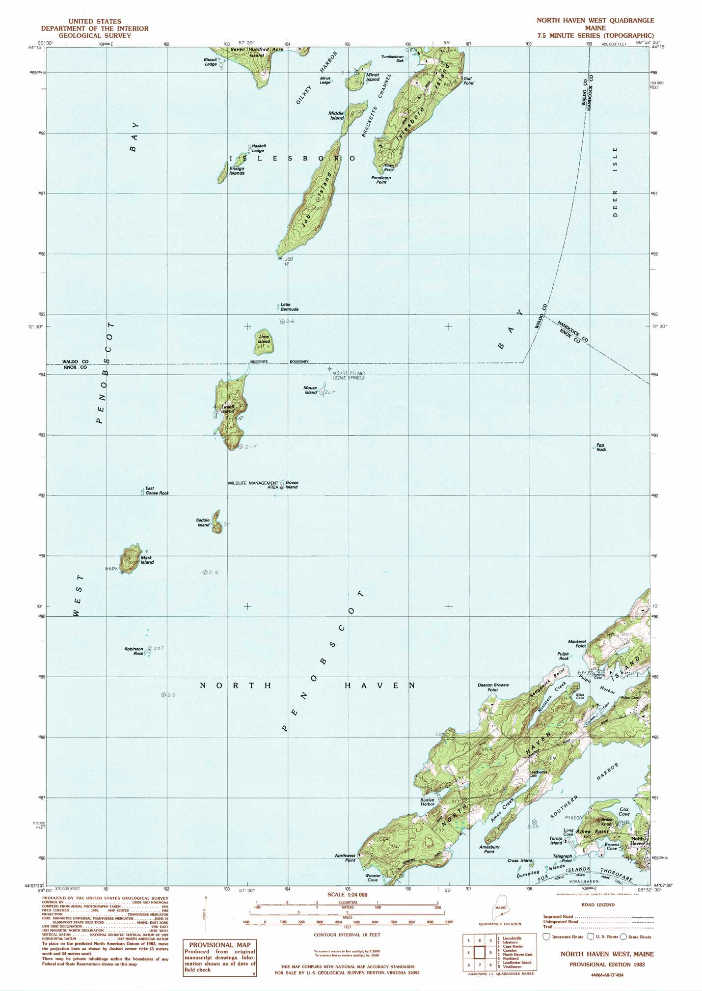
USGS Topo Quad 44068b8 - 1:24,000 scale
| Topo Map Name: | North Haven West |
| USGS Topo Quad ID: | 44068b8 |
| Print Size: | ca. 21 1/4" wide x 27" high |
| Southeast Coordinates: | 44.125° N latitude / 68.875° W longitude |
| Map Center Coordinates: | 44.1875° N latitude / 68.9375° W longitude |
| U.S. State: | ME |
| Filename: | o44068b8.jpg |
| Download Map JPG Image: | North Haven West topo map 1:24,000 scale |
| Map Type: | Topographic |
| Topo Series: | 7.5´ |
| Map Scale: | 1:24,000 |
| Source of Map Images: | United States Geological Survey (USGS) |
| Alternate Map Versions: |
North Haven West ME 1983, updated 1983 Download PDF Buy paper map North Haven West ME 2011 Download PDF Buy paper map North Haven West ME 2014 Download PDF Buy paper map |
1:24,000 Topo Quads surrounding North Haven West
Morrill |
Belfast |
Searsport |
Castine |
Penobscot |
Searsmont |
Lincolnville |
Islesboro |
Cape Rosier |
Sargentville |
West Rockport |
Camden |
North Haven West |
North Haven East |
Deer Isle |
Thomaston |
Rockland |
Leadbetter Island |
Vinalhaven |
Isle Au Haut West |
Tenants Harbor |
Hewett Island |
> Back to 44068a1 at 1:100,000 scale
> Back to 44068a1 at 1:250,000 scale
> Back to U.S. Topo Maps home
North Haven West topo map: Gazetteer
North Haven West: Airports
Witherspoons Airport elevation 21m 68′North Haven West: Bars
Biscuit Ledge elevation 1m 3′Egg Rock Ledge elevation 0m 0′
Haskell Ledge elevation 0m 0′
McIntosh Ledge elevation 0m 0′
Minor Ledge elevation 0m 0′
Seal Ledge elevation 0m 0′
Tumble down Dick elevation 0m 0′
North Haven West: Bays
Ames Creek elevation 0m 0′Bartlett Harbor elevation 0m 0′
Billys Cove elevation 0m 0′
Browns Cove elevation 5m 16′
Cox Cove elevation 0m 0′
Crockett Cove elevation 1m 3′
Long Cove elevation 1m 3′
Ministers Creek elevation 10m 32′
Nortons Cove elevation 3m 9′
Penobscot Bay elevation 0m 0′
Pulpit Harbor elevation 0m 0′
Southern Harbor elevation 0m 0′
Wooster Cove elevation 0m 0′
North Haven West: Capes
Ames Point elevation 0m 0′Amesbury Point elevation 0m 0′
Calf Point elevation 5m 16′
Deacon Brown Point elevation 5m 16′
Gull Point elevation 16m 52′
Mackerel Point elevation 12m 39′
Northwest Point elevation 23m 75′
Pendleton Point elevation 0m 0′
Sedgewick Point elevation 2m 6′
Telegraph Point elevation 3m 9′
North Haven West: Islands
Cross Island elevation 6m 19′Dumpling Island elevation 0m 0′
East Goose Rock elevation 0m 0′
Egg Rock elevation 0m 0′
Ensign Island elevation 0m 0′
Goose Island elevation 0m 0′
Job Island elevation 31m 101′
Lasell Island elevation 13m 42′
Lime Island elevation 4m 13′
Little Bermuda elevation 0m 0′
Lobster Island elevation 0m 0′
Mark Island elevation 28m 91′
Middle Island elevation 0m 0′
Minot Island elevation 0m 0′
Mouse Island elevation 0m 0′
Pulpit Rock elevation 0m 0′
Robinson Rock elevation 1m 3′
Saddle Island elevation 9m 29′
Turnip Island elevation 0m 0′
North Haven West: Populated Places
Pulpit Harbor elevation 13m 42′North Haven West: Summits
Ames Knob elevation 28m 91′North Haven West digital topo map on disk
Buy this North Haven West topo map showing relief, roads, GPS coordinates and other geographical features, as a high-resolution digital map file on DVD:
Maine, New Hampshire, Rhode Island & Eastern Massachusetts
Buy digital topo maps: Maine, New Hampshire, Rhode Island & Eastern Massachusetts