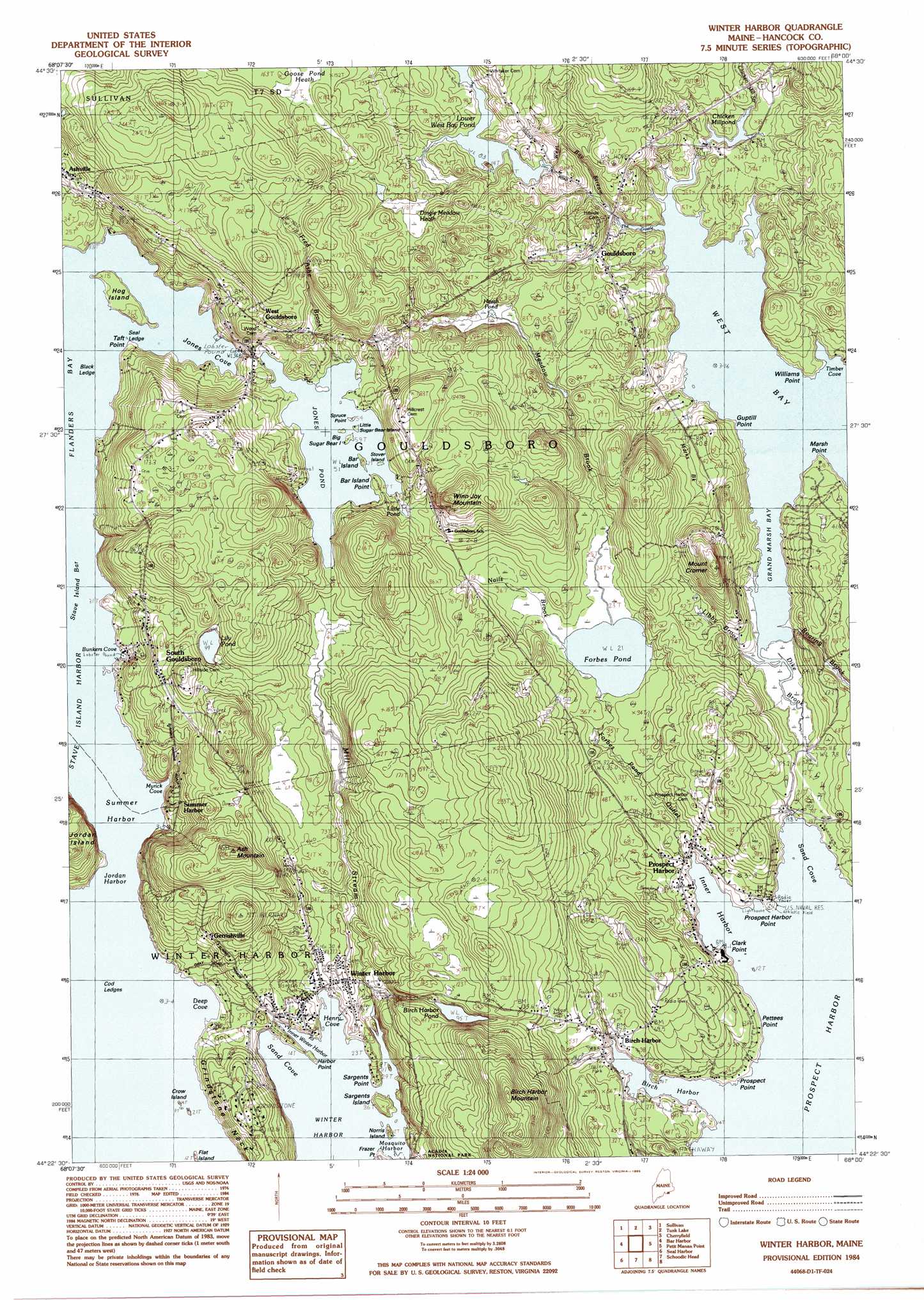
Winter Harbor Topo Map Maine
To zoom in, hover over the map of Winter Harbor
USGS Topo Quad 44068d1 - 1:24,000 scale
| Topo Map Name: | Winter Harbor |
| USGS Topo Quad ID: | 44068d1 |
| Print Size: | ca. 21 1/4" wide x 27" high |
| Southeast Coordinates: | 44.375° N latitude / 68° W longitude |
| Map Center Coordinates: | 44.4375° N latitude / 68.0625° W longitude |
| U.S. State: | ME |
| Filename: | o44068d1.jpg |
| Download Map JPG Image: | Winter Harbor topo map 1:24,000 scale |
| Map Type: | Topographic |
| Topo Series: | 7.5´ |
| Map Scale: | 1:24,000 |
| Source of Map Images: | United States Geological Survey (USGS) |
| Alternate Map Versions: |
Winter Harbor ME 1984, updated 1985 Download PDF Buy paper map Winter Harbor ME 1984, updated 1985 Download PDF Buy paper map Winter Harbor ME 2011 Download PDF Buy paper map Winter Harbor ME 2014 Download PDF Buy paper map |
1:24,000 Topo Quads surrounding Winter Harbor
Eastbrook |
Molasses Pond |
Tunk Mountain |
Schoodic Lake |
Epping |
Hancock |
Sullivan |
Tunk Lake |
Cherryfield |
Harrington |
Salsbury Cove |
Bar Harbor |
Winter Harbor |
Petit Manan Point |
Bois Bubert |
Southwest Harbor |
Seal Harbor |
Schoodic Head |
||
Bass Harbor |
Baker Island |
> Back to 44068a1 at 1:100,000 scale
> Back to 44068a1 at 1:250,000 scale
> Back to U.S. Topo Maps home
Winter Harbor topo map: Gazetteer
Winter Harbor: Bars
Abijah Ledge elevation 0m 0′Black Ledge elevation 0m 0′
Cod Ledges elevation 0m 0′
Roaring Bull elevation 0m 0′
Seal Ledge elevation 0m 0′
Seal Ledge elevation 0m 0′
Stave Island Bar elevation 0m 0′
Stave Island Bar elevation 0m 0′
Winter Harbor: Bays
Birch Harbor elevation 0m 0′Bunkers Cove elevation -1m -4′
Deep Cove elevation 0m 0′
Grand Marsh Bay elevation 0m 0′
Henry Cove elevation 0m 0′
Inner Harbor elevation 0m 0′
Inner Winter Harbor elevation 0m 0′
Jones Cove elevation 0m 0′
Jordan Harbor elevation 0m 0′
Mosquito Harbor elevation 0m 0′
Myrick Cove elevation 4m 13′
Prospect Harbor elevation 0m 0′
Sand Cove elevation 0m 0′
Sand Cove elevation 0m 0′
Summer Harbor elevation 0m 0′
Timber Cove elevation 7m 22′
West Bay elevation 0m 0′
Winter Harbor: Capes
Bar Island Point elevation 17m 55′Clark Point elevation 3m 9′
Frazer Point elevation 3m 9′
Grindstone Neck elevation 40m 131′
Guptill Point elevation 3m 9′
Harbor Point elevation 3m 9′
Marsh Point elevation 4m 13′
Pettees Point elevation 4m 13′
Prospect Harbor Point elevation 6m 19′
Prospect Point elevation 5m 16′
Sargents Point elevation 2m 6′
Spruce Point elevation 17m 55′
Taft Point elevation 9m 29′
Willisms Point elevation 8m 26′
Winter Harbor: Dams
Jones Pond Dam elevation 15m 49′Lower West Bay Pond Dam elevation 24m 78′
Winter Harbor: Islands
Bar Island elevation 16m 52′Big Sugar Bear Island elevation 16m 52′
Crow Island elevation 0m 0′
Flat Island elevation 0m 0′
Hog Island elevation 5m 16′
Jordan Island elevation 50m 164′
Little Sugar Bear Island elevation 15m 49′
Norris Island elevation 0m 0′
Sargents Island elevation 9m 29′
Stover Island elevation 18m 59′
Stover Island elevation 17m 55′
Winter Harbor: Lakes
Birch Harbor Pond elevation 29m 95′Chicken Millpond elevation 9m 29′
Forbes Pond elevation 6m 19′
Lily Pond elevation 31m 101′
Winter Harbor: Populated Places
Ashville elevation 27m 88′Birch Harbor elevation 9m 29′
Gerrishville elevation 41m 134′
Gouldsboro elevation 25m 82′
Prospect Harbor elevation 8m 26′
South Gouldsboro elevation 43m 141′
Summer Harbor elevation 27m 88′
West Gouldsboro elevation 36m 118′
Winter Harbor elevation 8m 26′
Winter Harbor: Reservoirs
Jones Pond elevation 15m 49′Little Pond elevation 16m 52′
Lower West Bay Pond elevation 24m 78′
Winter Harbor: Springs
Big Chief Spring elevation 8m 26′Winter Harbor: Streams
Chicken Mill Stream elevation 7m 22′Dike Brook elevation 0m 0′
Libby Brook elevation 2m 6′
Mill Stream elevation 3m 9′
Nails Brook elevation 8m 26′
Winter Harbor: Summits
Ash Mountain elevation 84m 275′Mount Cromer elevation 44m 144′
Winn Joy Mountain elevation 79m 259′
Winter Harbor: Swamps
Dingle Meadow Heath elevation 35m 114′Winter Harbor digital topo map on disk
Buy this Winter Harbor topo map showing relief, roads, GPS coordinates and other geographical features, as a high-resolution digital map file on DVD:
Maine, New Hampshire, Rhode Island & Eastern Massachusetts
Buy digital topo maps: Maine, New Hampshire, Rhode Island & Eastern Massachusetts