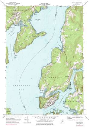
Castine Topo Map Maine
To zoom in, hover over the map of Castine
USGS Topo Quad 44068d7 - 1:24,000 scale
| Topo Map Name: | Castine |
| USGS Topo Quad ID: | 44068d7 |
| Print Size: | ca. 21 1/4" wide x 27" high |
| Southeast Coordinates: | 44.375° N latitude / 68.75° W longitude |
| Map Center Coordinates: | 44.4375° N latitude / 68.8125° W longitude |
| U.S. State: | ME |
| Filename: | o44068d7.jpg |
| Download Map JPG Image: | Castine topo map 1:24,000 scale |
| Map Type: | Topographic |
| Topo Series: | 7.5´ |
| Map Scale: | 1:24,000 |
| Source of Map Images: | United States Geological Survey (USGS) |
| Alternate Map Versions: |
Castine ME 1973, updated 1977 Download PDF Buy paper map Castine ME 1973, updated 1984 Download PDF Buy paper map Castine ME 1973, updated 1984 Download PDF Buy paper map Castine ME 2011 Download PDF Buy paper map Castine ME 2014 Download PDF Buy paper map |
1:24,000 Topo Quads surrounding Castine
> Back to 44068a1 at 1:100,000 scale
> Back to 44068a1 at 1:250,000 scale
> Back to U.S. Topo Maps home
Castine topo map: Gazetteer
Castine: Bars
Fort Point Ledge elevation 0m 0′Hosmer Ledge elevation 0m 0′
Middle Ground elevation 0m 0′
Otter Rock Shoal elevation 0m 0′
Trott Ledge elevation 0m 0′
Castine: Bays
Castine Harbor elevation 0m 0′Devereaux Cove elevation 0m 0′
Fort Point Cove elevation 0m 0′
Grants Cove elevation 0m 0′
Grindles Eddy elevation 0m 0′
Hatch Cove elevation 0m 0′
Lords Cove elevation 0m 0′
Mill Cove elevation 0m 0′
Morse Cove elevation 0m 0′
Stockton Harbor elevation 0m 0′
Wadsworth Cove elevation 0m 0′
Wasson Cove elevation 0m 0′
Castine: Canals
British Canal elevation 1m 3′Castine: Capes
Bagaduce Peninsula elevation 25m 82′Bickmore Point elevation 0m 0′
Blockhouse Point elevation 18m 59′
Cape Jellison elevation 53m 173′
Defence Point elevation 2m 6′
Dodges Point elevation 5m 16′
Fort Point elevation 2m 6′
Henry Point elevation 5m 16′
Jones Point elevation 7m 22′
Mayo Point elevation 6m 19′
Perkins Point elevation 5m 16′
Sandy Point elevation 10m 32′
Turner Point elevation 3m 9′
Wilson Point elevation 5m 16′
Castine: Cliffs
Dice Head elevation 10m 32′Castine: Islands
Grays Island elevation 6m 19′Great Island elevation 12m 39′
Henry Islands elevation 2m 6′
High Tide Island elevation 1m 3′
Hospital Island elevation 5m 16′
Lower Negro Island elevation 7m 22′
Negro Island elevation 0m 0′
Upper Negro Island elevation 8m 26′
Castine: Lakes
Mill Pond elevation 0m 0′Castine: Parks
Castine Historic District elevation 52m 170′Fort Point State Park elevation 10m 32′
Ritchie Field elevation 19m 62′
Witherle Park elevation 57m 187′
Castine: Populated Places
Castine elevation 25m 82′Fort George elevation 56m 183′
North Castine elevation 34m 111′
Penobscot (historical) elevation 25m 82′
Stockton Springs elevation 40m 131′
West Brooksville elevation 31m 101′
West Castine elevation 31m 101′
West Penobscot elevation 18m 59′
Castine: Streams
Bagaduce River elevation 0m 0′Bog Brook elevation 3m 9′
Clements Brook elevation 3m 9′
Penobscot River elevation 0m 0′
Shepardson Brook elevation 0m 0′
Smell Brook elevation 0m 0′
Castine: Summits
Defence Head elevation 5m 16′Perkins Mountain elevation 75m 246′
Whites Head elevation 17m 55′
Castine digital topo map on disk
Buy this Castine topo map showing relief, roads, GPS coordinates and other geographical features, as a high-resolution digital map file on DVD:
Maine, New Hampshire, Rhode Island & Eastern Massachusetts
Buy digital topo maps: Maine, New Hampshire, Rhode Island & Eastern Massachusetts


