Tunk Lake Topo Map Maine
To zoom in, hover over the map of Tunk Lake
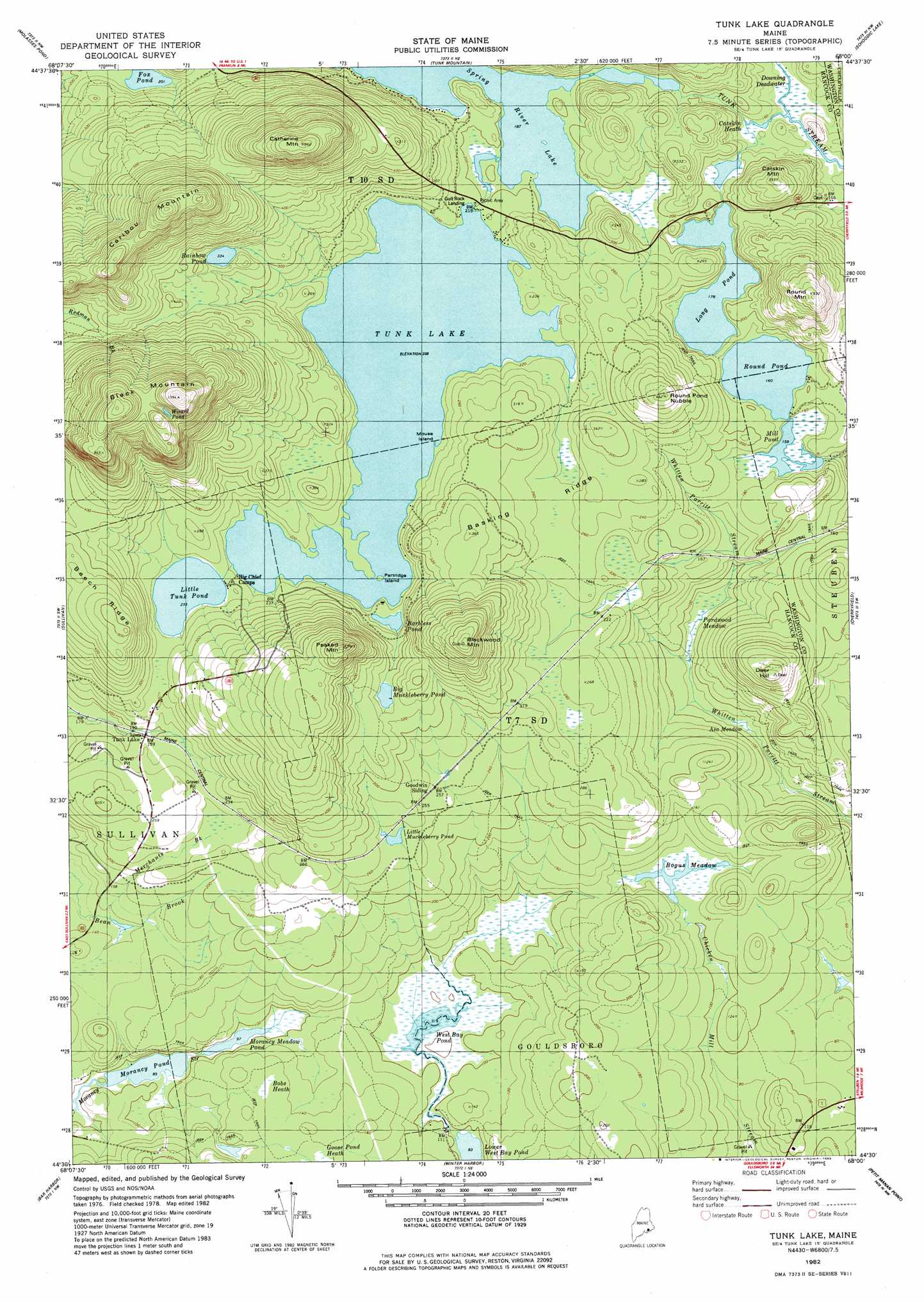
USGS Topo Quad 44068e1 - 1:24,000 scale
| Topo Map Name: | Tunk Lake |
| USGS Topo Quad ID: | 44068e1 |
| Print Size: | ca. 21 1/4" wide x 27" high |
| Southeast Coordinates: | 44.5° N latitude / 68° W longitude |
| Map Center Coordinates: | 44.5625° N latitude / 68.0625° W longitude |
| U.S. State: | ME |
| Filename: | o44068e1.jpg |
| Download Map JPG Image: | Tunk Lake topo map 1:24,000 scale |
| Map Type: | Topographic |
| Topo Series: | 7.5´ |
| Map Scale: | 1:24,000 |
| Source of Map Images: | United States Geological Survey (USGS) |
| Alternate Map Versions: |
Tunk Lake ME 1982, updated 1983 Download PDF Buy paper map Tunk Lake ME 2011 Download PDF Buy paper map Tunk Lake ME 2014 Download PDF Buy paper map |
1:24,000 Topo Quads surrounding Tunk Lake
Amherst |
Rocky Pond |
Lead Mountain |
Northeast Bluff |
Montegail Pond |
Eastbrook |
Molasses Pond |
Tunk Mountain |
Schoodic Lake |
Epping |
Hancock |
Sullivan |
Tunk Lake |
Cherryfield |
Harrington |
Salsbury Cove |
Bar Harbor |
Winter Harbor |
Petit Manan Point |
Bois Bubert |
Southwest Harbor |
Seal Harbor |
Schoodic Head |
> Back to 44068e1 at 1:100,000 scale
> Back to 44068a1 at 1:250,000 scale
> Back to U.S. Topo Maps home
Tunk Lake topo map: Gazetteer
Tunk Lake: Dams
Barbless Pond Dam elevation 64m 209′West Bay Pond Dam elevation 31m 101′
Tunk Lake: Islands
Mouse Island elevation 63m 206′Partridge Island elevation 63m 206′
Tunk Lake: Lakes
Big Muckleberry Pond elevation 103m 337′Downing Pond elevation 45m 147′
Little Tunk Pond elevation 71m 232′
Long Pond elevation 54m 177′
Mill Pond elevation 48m 157′
Morancy Meadow Pond elevation 29m 95′
Morancy Pond elevation 27m 88′
Muckleberry Pond elevation 76m 249′
Rainbow Pond elevation 102m 334′
Round Pond elevation 49m 160′
Spring River Lake elevation 57m 187′
Tunk Lake elevation 63m 206′
Upper Pond elevation 28m 91′
Wizard Pond elevation 281m 921′
Tunk Lake: Populated Places
Goodwin Siding elevation 79m 259′Tunk Lake elevation 61m 200′
Tunk Lake: Reservoirs
Barbless Pond elevation 64m 209′West Bay Pond elevation 31m 101′
Tunk Lake: Ridges
Basking Ridge elevation 76m 249′Beech Ridge elevation 139m 456′
Tunk Lake: Streams
Merchants Brook elevation 41m 134′Tunk Lake: Summits
Black Mountain elevation 304m 997′Blackwood Mountain elevation 194m 636′
Caribou Mountain elevation 259m 849′
Catherine Mountain elevation 284m 931′
Catskin Mountain elevation 117m 383′
Deer Hill elevation 130m 426′
Peaked Mountain elevation 201m 659′
Round Mountain elevation 171m 561′
Round Pond Nubble elevation 136m 446′
Tunk Lake: Swamps
Asa Meadow elevation 21m 68′Bobs Heath elevation 46m 150′
Bogus Meadow elevation 34m 111′
Catskin Heath elevation 46m 150′
Downing Deadwater elevation 98m 321′
Goose Pond Heath elevation 46m 150′
Pardwood Meadow elevation 24m 78′
Tunk Lake digital topo map on disk
Buy this Tunk Lake topo map showing relief, roads, GPS coordinates and other geographical features, as a high-resolution digital map file on DVD:
Maine, New Hampshire, Rhode Island & Eastern Massachusetts
Buy digital topo maps: Maine, New Hampshire, Rhode Island & Eastern Massachusetts