Hancock Topo Map Maine
To zoom in, hover over the map of Hancock
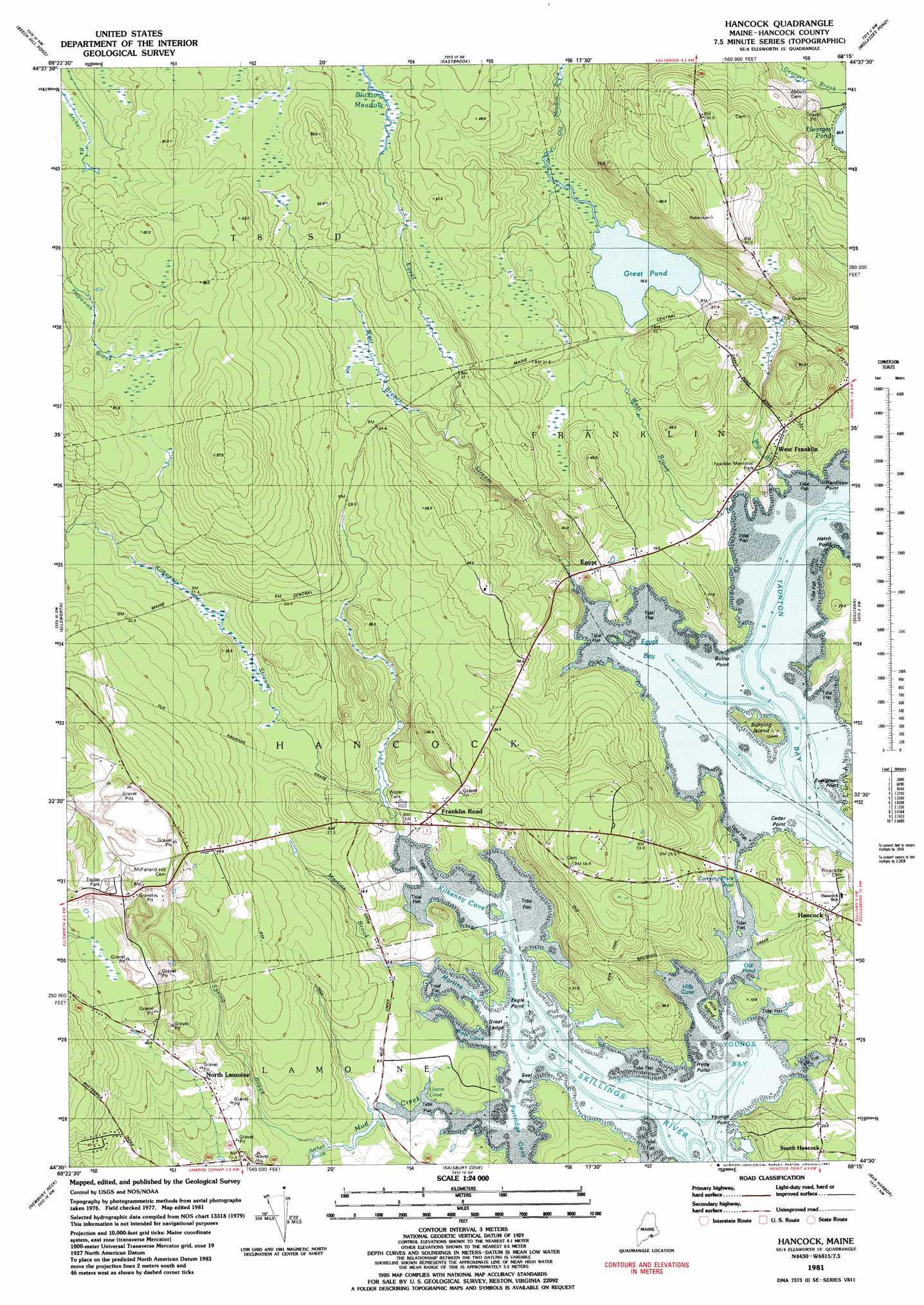
USGS Topo Quad 44068e3 - 1:24,000 scale
| Topo Map Name: | Hancock |
| USGS Topo Quad ID: | 44068e3 |
| Print Size: | ca. 21 1/4" wide x 27" high |
| Southeast Coordinates: | 44.5° N latitude / 68.25° W longitude |
| Map Center Coordinates: | 44.5625° N latitude / 68.3125° W longitude |
| U.S. State: | ME |
| Filename: | o44068e3.jpg |
| Download Map JPG Image: | Hancock topo map 1:24,000 scale |
| Map Type: | Topographic |
| Topo Series: | 7.5´ |
| Map Scale: | 1:24,000 |
| Source of Map Images: | United States Geological Survey (USGS) |
| Alternate Map Versions: |
Hancock ME 1981, updated 1982 Download PDF Buy paper map Hancock ME 2011 Download PDF Buy paper map Hancock ME 2014 Download PDF Buy paper map |
1:24,000 Topo Quads surrounding Hancock
Chemo Pond |
Hopkins Pond |
Amherst |
Rocky Pond |
Lead Mountain |
Green Lake |
Beech Hill Pond |
Eastbrook |
Molasses Pond |
Tunk Mountain |
Branch Lake |
Ellsworth |
Hancock |
Sullivan |
Tunk Lake |
Blue Hill |
Newbury Neck |
Salsbury Cove |
Bar Harbor |
Winter Harbor |
Brooklin |
Bartlett Island |
Southwest Harbor |
Seal Harbor |
Schoodic Head |
> Back to 44068e1 at 1:100,000 scale
> Back to 44068a1 at 1:250,000 scale
> Back to U.S. Topo Maps home
Hancock topo map: Gazetteer
Hancock: Bars
Great Ledge elevation 1m 3′Hancock: Bays
Egypt Bay elevation 0m 0′Hills Cove elevation 0m 0′
Kilkenny Cove elevation 0m 0′
Martins Cove elevation 0m 0′
Partridge Cove elevation 0m 0′
Taunton Bay elevation 0m 0′
Urann Cove elevation 7m 22′
Weir Cove elevation 0m 0′
Youngs Bay elevation 0m 0′
Hancock: Capes
Butler Point elevation 7m 22′Cedar Point elevation 0m 0′
Eagle Point elevation 3m 9′
Hardison Point elevation 3m 9′
Hatch Point elevation 9m 29′
Hyde Point elevation 1m 3′
Seal Point elevation 1m 3′
Youngs Point elevation 1m 3′
Hancock: Channels
Carrying Place Inlet elevation 2m 6′Hancock: Islands
Burying Island elevation 18m 59′Hills Island elevation 3m 9′
Hancock: Lakes
Great Pond elevation 15m 49′Mill Pond elevation 14m 45′
Old Pond elevation 0m 0′
Hancock: Parks
Franklin Memorial Park elevation 9m 29′Hancock: Populated Places
Egypt elevation 0m 0′Franklin Road elevation 16m 52′
Hancock elevation 11m 36′
North Lamoine elevation 21m 68′
South Hancock elevation 24m 78′
West Franklin elevation 19m 62′
Hancock: Streams
Archer Brook elevation 2m 6′Egypt Stream elevation 0m 0′
Kilkenny Stream elevation 1m 3′
Martins Brook elevation 3m 9′
Mill Brook elevation 2m 6′
Mud Creek elevation 5m 16′
Old Meadow Brook elevation 17m 55′
Spring Brook elevation 0m 0′
West Branch Egypt Stream elevation 24m 78′
West Brook elevation 1m 3′
Hancock digital topo map on disk
Buy this Hancock topo map showing relief, roads, GPS coordinates and other geographical features, as a high-resolution digital map file on DVD:
Maine, New Hampshire, Rhode Island & Eastern Massachusetts
Buy digital topo maps: Maine, New Hampshire, Rhode Island & Eastern Massachusetts