Ellsworth Topo Map Maine
To zoom in, hover over the map of Ellsworth
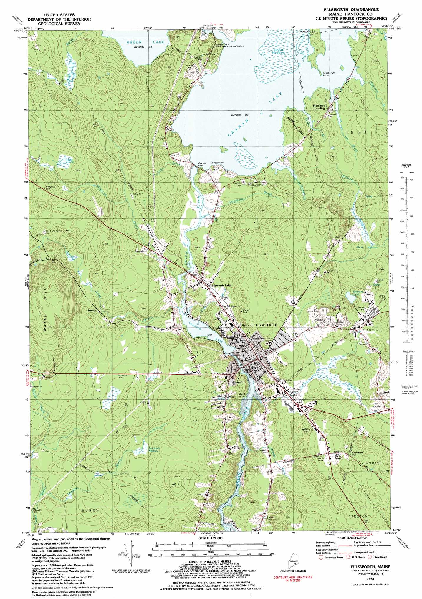
USGS Topo Quad 44068e4 - 1:24,000 scale
| Topo Map Name: | Ellsworth |
| USGS Topo Quad ID: | 44068e4 |
| Print Size: | ca. 21 1/4" wide x 27" high |
| Southeast Coordinates: | 44.5° N latitude / 68.375° W longitude |
| Map Center Coordinates: | 44.5625° N latitude / 68.4375° W longitude |
| U.S. State: | ME |
| Filename: | o44068e4.jpg |
| Download Map JPG Image: | Ellsworth topo map 1:24,000 scale |
| Map Type: | Topographic |
| Topo Series: | 7.5´ |
| Map Scale: | 1:24,000 |
| Source of Map Images: | United States Geological Survey (USGS) |
| Alternate Map Versions: |
Ellsworth ME 1981, updated 1982 Download PDF Buy paper map Ellsworth ME 2011 Download PDF Buy paper map Ellsworth ME 2014 Download PDF Buy paper map |
1:24,000 Topo Quads surrounding Ellsworth
Veazie |
Chemo Pond |
Hopkins Pond |
Amherst |
Rocky Pond |
Brewer Lake |
Green Lake |
Beech Hill Pond |
Eastbrook |
Molasses Pond |
Orland |
Branch Lake |
Ellsworth |
Hancock |
Sullivan |
Penobscot |
Blue Hill |
Newbury Neck |
Salsbury Cove |
Bar Harbor |
Sargentville |
Brooklin |
Bartlett Island |
Southwest Harbor |
Seal Harbor |
> Back to 44068e1 at 1:100,000 scale
> Back to 44068a1 at 1:250,000 scale
> Back to U.S. Topo Maps home
Ellsworth topo map: Gazetteer
Ellsworth: Capes
Beech Hill Point elevation 33m 108′Black Point elevation 3m 9′
Murches Point elevation 3m 9′
Ellsworth: Dams
Ellsworth Dam elevation 19m 62′Ellsworth Water Company Dam elevation 20m 65′
Graham Lake Dam elevation 32m 104′
Ellsworth: Flats
Back Meadow elevation 49m 160′Ellsworth: Lakes
Big Pond elevation 92m 301′Simmons Pond elevation 55m 180′
Ellsworth: Parks
Birdsacre Wildlife Sanctuary elevation 43m 141′Ellsworth Waterford Park and Marina elevation 3m 9′
Stanwood Homestead Museum and Wildlife Sanctuary elevation 54m 177′
Ellsworth: Populated Places
Ellsworth elevation 33m 108′Ellsworth Falls elevation 38m 124′
Fletchers Landing elevation 33m 108′
Joyville elevation 42m 137′
Washington Junction elevation 60m 196′
Ellsworth: Post Offices
Ellsworth Post Office elevation 22m 72′Ellsworth: Reservoirs
Branch Lake Stream elevation 38m 124′Graham Lake elevation 32m 104′
Leonard Lake elevation 19m 62′
Ellsworth: Streams
Archer Brook elevation 36m 118′Branch Lake Stream elevation 20m 65′
Card Brook elevation 6m 19′
Day Brook elevation 32m 104′
Deadman Brook elevation 31m 101′
Gilpatrick Brook elevation 22m 72′
Greys Brook elevation 25m 82′
Hapworth Brook elevation 35m 114′
Little Meadow Brook elevation 32m 104′
Meadow Brook elevation 45m 147′
Moore Brook elevation 26m 85′
Patten Stream elevation 23m 75′
Rankin Brook elevation 32m 104′
Sawpit Brook elevation 44m 144′
Shackford Brook elevation 26m 85′
Whittaker Brook elevation 11m 36′
Ellsworth: Summits
Beckwith Hill elevation 94m 308′Watts Hill elevation 122m 400′
Ellsworth: Swamps
Cushmans Meadow elevation 56m 183′Great Meadow elevation 34m 111′
Ellsworth digital topo map on disk
Buy this Ellsworth topo map showing relief, roads, GPS coordinates and other geographical features, as a high-resolution digital map file on DVD:
Maine, New Hampshire, Rhode Island & Eastern Massachusetts
Buy digital topo maps: Maine, New Hampshire, Rhode Island & Eastern Massachusetts