Branch Lake Topo Map Maine
To zoom in, hover over the map of Branch Lake
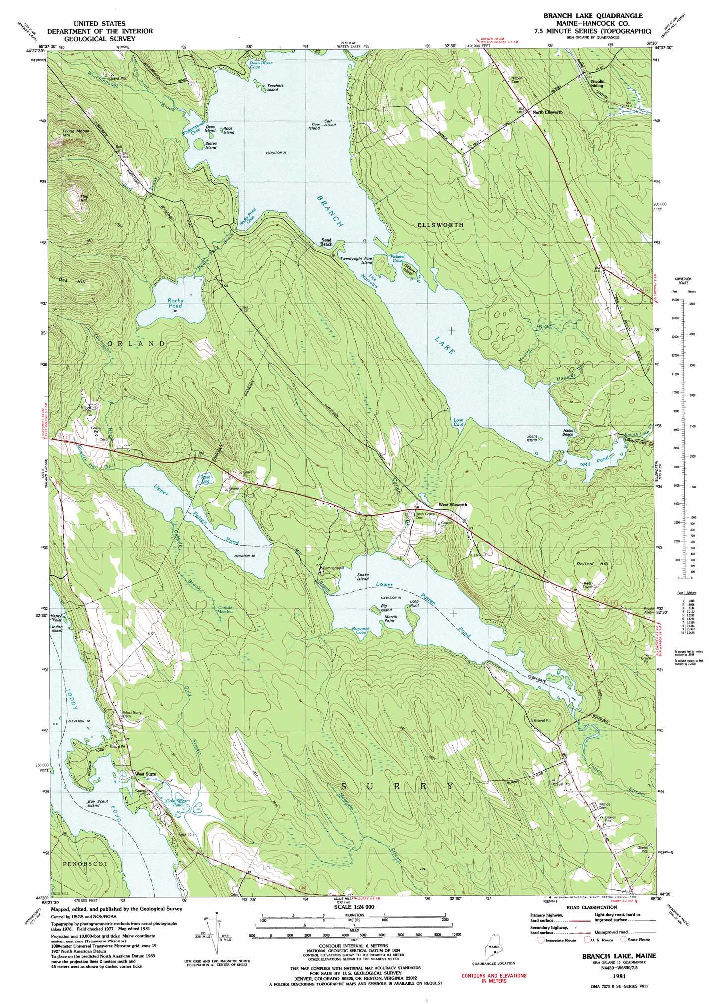
USGS Topo Quad 44068e5 - 1:24,000 scale
| Topo Map Name: | Branch Lake |
| USGS Topo Quad ID: | 44068e5 |
| Print Size: | ca. 21 1/4" wide x 27" high |
| Southeast Coordinates: | 44.5° N latitude / 68.5° W longitude |
| Map Center Coordinates: | 44.5625° N latitude / 68.5625° W longitude |
| U.S. State: | ME |
| Filename: | o44068e5.jpg |
| Download Map JPG Image: | Branch Lake topo map 1:24,000 scale |
| Map Type: | Topographic |
| Topo Series: | 7.5´ |
| Map Scale: | 1:24,000 |
| Source of Map Images: | United States Geological Survey (USGS) |
| Alternate Map Versions: |
Branch Lake ME 1981, updated 1982 Download PDF Buy paper map Branch Lake ME 1981, updated 1982 Download PDF Buy paper map Branch Lake ME 2011 Download PDF Buy paper map Branch Lake ME 2014 Download PDF Buy paper map |
1:24,000 Topo Quads surrounding Branch Lake
Bangor |
Veazie |
Chemo Pond |
Hopkins Pond |
Amherst |
Hampden |
Brewer Lake |
Green Lake |
Beech Hill Pond |
Eastbrook |
Bucksport |
Orland |
Branch Lake |
Ellsworth |
Hancock |
Castine |
Penobscot |
Blue Hill |
Newbury Neck |
Salsbury Cove |
Cape Rosier |
Sargentville |
Brooklin |
Bartlett Island |
Southwest Harbor |
> Back to 44068e1 at 1:100,000 scale
> Back to 44068a1 at 1:250,000 scale
> Back to U.S. Topo Maps home
Branch Lake topo map: Gazetteer
Branch Lake: Bays
Dean Brook Cove elevation 73m 239′Loon Cove elevation 73m 239′
Musquash Cove elevation 41m 134′
Pickeral Cove elevation 73m 239′
Rocky Pond Cove elevation 73m 239′
Winkumpaugh Cove elevation 73m 239′
Branch Lake: Beaches
Hales Beach elevation 73m 239′Branch Lake: Capes
Haney Point elevation 50m 164′Long Point elevation 42m 137′
Merrill Point elevation 41m 134′
Branch Lake: Channels
The Narrows elevation 73m 239′Branch Lake: Dams
Branch Lake Dam elevation 73m 239′Lower Patten Pond Dam elevation 41m 134′
Branch Lake: Islands
Big Island elevation 42m 137′Boy Scout Island elevation 50m 164′
Calf Island elevation 73m 239′
Cow Island elevation 73m 239′
Dees Island elevation 73m 239′
Huney Point elevation 50m 164′
Indian Island elevation 50m 164′
Johns Island elevation 73m 239′
Pickerel Island elevation 78m 255′
Rock Island elevation 73m 239′
Snake Island elevation 41m 134′
Steres Island elevation 73m 239′
Teachers Island elevation 73m 239′
Twenty Acre Island elevation 77m 252′
Branch Lake: Lakes
Gold Stream Pond elevation 57m 187′Mill Pond elevation 73m 239′
Rocky Pond elevation 95m 311′
Toddy Pond elevation 50m 164′
Upper Patten Pond elevation 50m 164′
Upper Patten Pond elevation 50m 164′
Branch Lake: Populated Places
Hurds Corner elevation 137m 449′Nicolin (historical) elevation 84m 275′
North Ellsworth elevation 134m 439′
Sand Beach elevation 76m 249′
West Ellsworth elevation 84m 275′
West Surry elevation 60m 196′
Branch Lake: Reservoirs
Branch Lake elevation 73m 239′Lower Patten Pond elevation 41m 134′
Branch Lake: Streams
Bowden Hill Brook elevation 50m 164′Carlisle Brook elevation 50m 164′
Carters Brook elevation 41m 134′
Dean Brook elevation 73m 239′
Gott Brook elevation 83m 272′
Howards Brook elevation 77m 252′
John Gray Brook elevation 77m 252′
Mill Brook elevation 41m 134′
Moore Brook elevation 51m 167′
Rocky Pond Brook elevation 95m 311′
Thompson Brook elevation 53m 173′
Winkumpaugh Brook elevation 74m 242′
Branch Lake: Summits
Dollard Hill elevation 156m 511′Flag Hill elevation 270m 885′
Oak Hill elevation 223m 731′
Branch Lake: Swamps
Carlisle Meadow elevation 59m 193′Jesse Bog elevation 51m 167′
Branch Lake digital topo map on disk
Buy this Branch Lake topo map showing relief, roads, GPS coordinates and other geographical features, as a high-resolution digital map file on DVD:
Maine, New Hampshire, Rhode Island & Eastern Massachusetts
Buy digital topo maps: Maine, New Hampshire, Rhode Island & Eastern Massachusetts