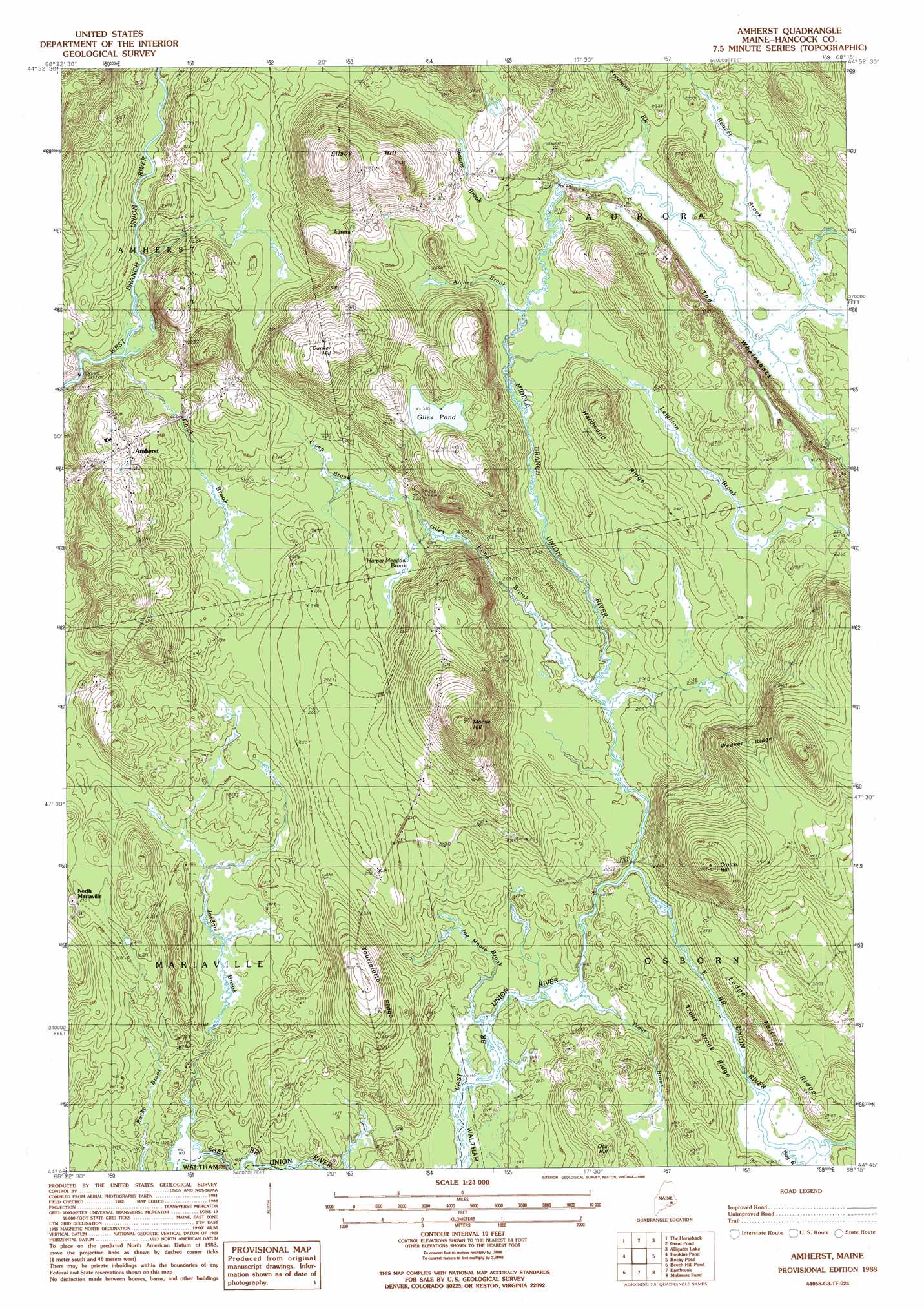
Amherst Topo Map Maine
To zoom in, hover over the map of Amherst
USGS Topo Quad 44068g3 - 1:24,000 scale
| Topo Map Name: | Amherst |
| USGS Topo Quad ID: | 44068g3 |
| Print Size: | ca. 21 1/4" wide x 27" high |
| Southeast Coordinates: | 44.75° N latitude / 68.25° W longitude |
| Map Center Coordinates: | 44.8125° N latitude / 68.3125° W longitude |
| U.S. State: | ME |
| Filename: | o44068g3.jpg |
| Download Map JPG Image: | Amherst topo map 1:24,000 scale |
| Map Type: | Topographic |
| Topo Series: | 7.5´ |
| Map Scale: | 1:24,000 |
| Source of Map Images: | United States Geological Survey (USGS) |
| Alternate Map Versions: |
Amherst ME 1988, updated 1988 Download PDF Buy paper map Amherst ME 2011 Download PDF Buy paper map Amherst ME 2014 Download PDF Buy paper map |
1:24,000 Topo Quads surrounding Amherst
Olamon |
Greenfield |
Brandy Pond |
West Lake |
Gassabias Lake |
Otter Chain Ponds |
The Horseback |
Great Pond |
Alligator Lake |
Quillpig Mountain |
Chemo Pond |
Hopkins Pond |
Amherst |
Rocky Pond |
Lead Mountain |
Green Lake |
Beech Hill Pond |
Eastbrook |
Molasses Pond |
Tunk Mountain |
Branch Lake |
Ellsworth |
Hancock |
Sullivan |
Tunk Lake |
> Back to 44068e1 at 1:100,000 scale
> Back to 44068a1 at 1:250,000 scale
> Back to U.S. Topo Maps home
Amherst topo map: Gazetteer
Amherst: Dams
Ledge Falls Dam (historical) elevation 71m 232′Amherst: Lakes
Giles Pond elevation 106m 347′Amherst: Populated Places
Amherst elevation 85m 278′Aurora elevation 101m 331′
North Mariaville elevation 64m 209′
Amherst: Post Offices
Aurora Post Office elevation 101m 331′Amherst: Ridges
Hardwood Ridge elevation 108m 354′Ledge Falls Ridge elevation 108m 354′
The Whalesback elevation 73m 239′
Tourtelotte Ridge elevation 118m 387′
Trout Brook Ridge elevation 98m 321′
Weaver Ridge elevation 169m 554′
Amherst: Streams
Archer Brook elevation 71m 232′Beaver Brook elevation 72m 236′
Bog River elevation 71m 232′
Browns Brook elevation 71m 232′
Camp Brook elevation 65m 213′
Chick Brook elevation 52m 170′
Freeman Brook elevation 73m 239′
Giles Pond Brook elevation 60m 196′
Harper Meadow Brook elevation 63m 206′
Joe Moore Brook elevation 51m 167′
Jordan Brook elevation 32m 104′
Leighton Brook elevation 70m 229′
Middle Branch Union River elevation 60m 196′
Trout Brook elevation 51m 167′
Amherst: Summits
Crotch Hill elevation 171m 561′Dunker Hill elevation 152m 498′
Moose Hill elevation 190m 623′
Oak Hill elevation 85m 278′
Silsby Hill elevation 180m 590′
Amherst digital topo map on disk
Buy this Amherst topo map showing relief, roads, GPS coordinates and other geographical features, as a high-resolution digital map file on DVD:
Maine, New Hampshire, Rhode Island & Eastern Massachusetts
Buy digital topo maps: Maine, New Hampshire, Rhode Island & Eastern Massachusetts