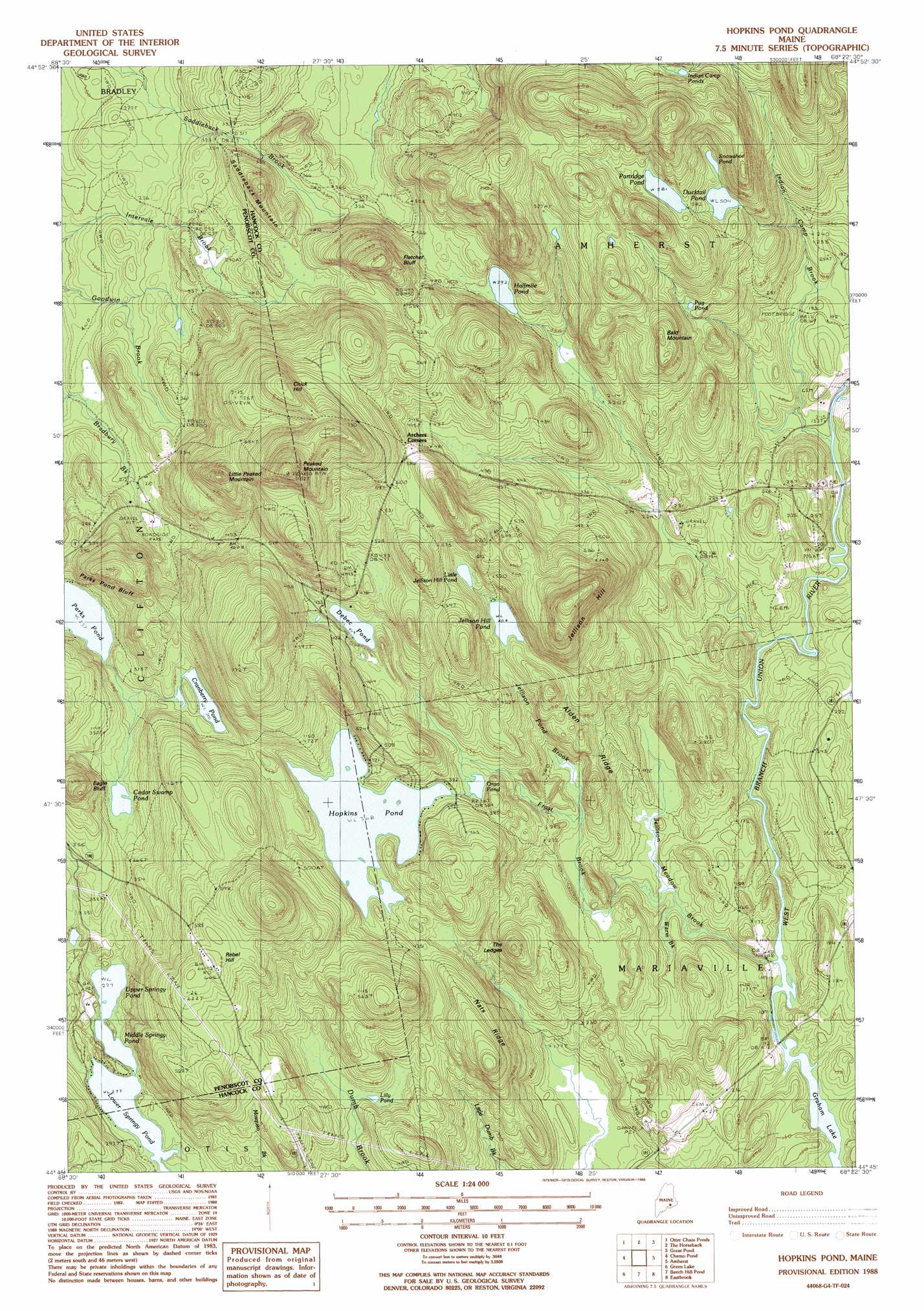
Hopkins Pond Topo Map Maine
To zoom in, hover over the map of Hopkins Pond
USGS Topo Quad 44068g4 - 1:24,000 scale
| Topo Map Name: | Hopkins Pond |
| USGS Topo Quad ID: | 44068g4 |
| Print Size: | ca. 21 1/4" wide x 27" high |
| Southeast Coordinates: | 44.75° N latitude / 68.375° W longitude |
| Map Center Coordinates: | 44.8125° N latitude / 68.4375° W longitude |
| U.S. State: | ME |
| Filename: | o44068g4.jpg |
| Download Map JPG Image: | Hopkins Pond topo map 1:24,000 scale |
| Map Type: | Topographic |
| Topo Series: | 7.5´ |
| Map Scale: | 1:24,000 |
| Source of Map Images: | United States Geological Survey (USGS) |
| Alternate Map Versions: |
Hopkins Pond ME 1988, updated 1988 Download PDF Buy paper map Hopkins Pond ME 2011 Download PDF Buy paper map Hopkins Pond ME 2014 Download PDF Buy paper map |
1:24,000 Topo Quads surrounding Hopkins Pond
Greenbush |
Olamon |
Greenfield |
Brandy Pond |
West Lake |
Old Town |
Otter Chain Ponds |
The Horseback |
Great Pond |
Alligator Lake |
Veazie |
Chemo Pond |
Hopkins Pond |
Amherst |
Rocky Pond |
Brewer Lake |
Green Lake |
Beech Hill Pond |
Eastbrook |
Molasses Pond |
Orland |
Branch Lake |
Ellsworth |
Hancock |
Sullivan |
> Back to 44068e1 at 1:100,000 scale
> Back to 44068a1 at 1:250,000 scale
> Back to U.S. Topo Maps home
Hopkins Pond topo map: Gazetteer
Hopkins Pond: Benches
The Ledges elevation 160m 524′Hopkins Pond: Bridges
Goodwin Bridge elevation 32m 104′Twin Bridges elevation 65m 213′
Hopkins Pond: Cliffs
Eagle Bluff elevation 156m 511′Fletcher Bluff elevation 244m 800′
Parks Pond Bluff elevation 129m 423′
Hopkins Pond: Lakes
Cedar Swamp Pond elevation 96m 314′Cranberry Pond elevation 103m 337′
Debec Pond elevation 125m 410′
Ducktail Pond elevation 155m 508′
Halfmile Pond elevation 119m 390′
Hopkins Pond elevation 112m 367′
Indian Camp Ponds elevation 170m 557′
Jellison Hill Pond elevation 123m 403′
Lilly Pond elevation 109m 357′
Little Jellison Hill Pond elevation 140m 459′
Lower Springy Pond elevation 84m 275′
Middle Springy Pond elevation 84m 275′
Oran Pond elevation 105m 344′
Parks Pond elevation 78m 255′
Partridge Pond elevation 177m 580′
Pug Pond elevation 150m 492′
Snowshoe Pond elevation 160m 524′
Upper Springy Pond elevation 84m 275′
Hopkins Pond: Populated Places
Archers Corners elevation 174m 570′Hopkins Pond: Ridges
Alden Ridge elevation 110m 360′Nats Ridge elevation 167m 547′
Hopkins Pond: Streams
Frost Brook elevation 39m 127′Indian Camp Brook elevation 45m 147′
Jellison Meadow Brook elevation 35m 114′
Jellison Pond Brook elevation 73m 239′
Warm Brook elevation 38m 124′
Hopkins Pond: Summits
Bald Mountain elevation 208m 682′Chick Hill elevation 271m 889′
Jellison Hill elevation 284m 931′
Little Peaked Mountain elevation 260m 853′
Peaked Mountain elevation 350m 1148′
Rebel Hill elevation 201m 659′
Saddleback Mountain elevation 165m 541′
Hopkins Pond: Trails
Peaked Mountain Trail elevation 209m 685′Hopkins Pond digital topo map on disk
Buy this Hopkins Pond topo map showing relief, roads, GPS coordinates and other geographical features, as a high-resolution digital map file on DVD:
Maine, New Hampshire, Rhode Island & Eastern Massachusetts
Buy digital topo maps: Maine, New Hampshire, Rhode Island & Eastern Massachusetts