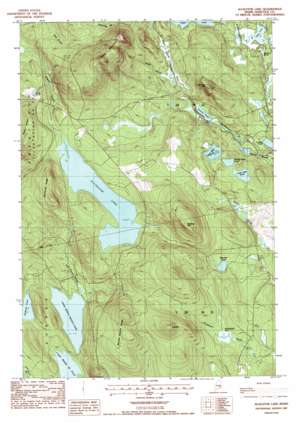
Alligator Lake Topo Map Maine
To zoom in, hover over the map of Alligator Lake
USGS Topo Quad 44068h2 - 1:24,000 scale
| Topo Map Name: | Alligator Lake |
| USGS Topo Quad ID: | 44068h2 |
| Print Size: | ca. 21 1/4" wide x 27" high |
| Southeast Coordinates: | 44.875° N latitude / 68.125° W longitude |
| Map Center Coordinates: | 44.9375° N latitude / 68.1875° W longitude |
| U.S. State: | ME |
| Filename: | o44068h2.jpg |
| Download Map JPG Image: | Alligator Lake topo map 1:24,000 scale |
| Map Type: | Topographic |
| Topo Series: | 7.5´ |
| Map Scale: | 1:24,000 |
| Source of Map Images: | United States Geological Survey (USGS) |
| Alternate Map Versions: |
Alligator Lake ME 1987, updated 1988 Download PDF Buy paper map Alligator Lake ME 2011 Download PDF Buy paper map Alligator Lake ME 2014 Download PDF Buy paper map |
1:24,000 Topo Quads surrounding Alligator Lake
> Back to 44068e1 at 1:100,000 scale
> Back to 44068a1 at 1:250,000 scale
> Back to U.S. Topo Maps home
Alligator Lake topo map: Gazetteer
Alligator Lake: Lakes
Alligator Lake elevation 141m 462′Deer Lake elevation 117m 383′
Duds Pond elevation 151m 495′
Halfmile Pond elevation 132m 433′
Haycock Pond elevation 120m 393′
Jimmies Pond elevation 118m 387′
Lovejoy Pond elevation 117m 383′
Lower Allen Pond elevation 141m 462′
Lower Middle Branch Pond elevation 98m 321′
Middle Allen Pond elevation 138m 452′
Upper Allen Pond elevation 145m 475′
Upper Middle Branch Pond elevation 103m 337′
Williams Pond elevation 129m 423′
Alligator Lake: Ridges
Baker Ridge elevation 201m 659′Bamfords Ridge elevation 243m 797′
Middle Branch Ridge elevation 223m 731′
Alligator Lake: Streams
John Brown Brook elevation 106m 347′Alligator Lake: Summits
Blackcap Mountain elevation 283m 928′Eagle Mountain elevation 327m 1072′
Jimmies Mountain elevation 216m 708′
Pinnacle elevation 281m 921′
Alligator Lake: Swamps
Humpback Bog elevation 132m 433′Alligator Lake digital topo map on disk
Buy this Alligator Lake topo map showing relief, roads, GPS coordinates and other geographical features, as a high-resolution digital map file on DVD:
Maine, New Hampshire, Rhode Island & Eastern Massachusetts
Buy digital topo maps: Maine, New Hampshire, Rhode Island & Eastern Massachusetts


