Damariscotta Topo Map Maine
To zoom in, hover over the map of Damariscotta
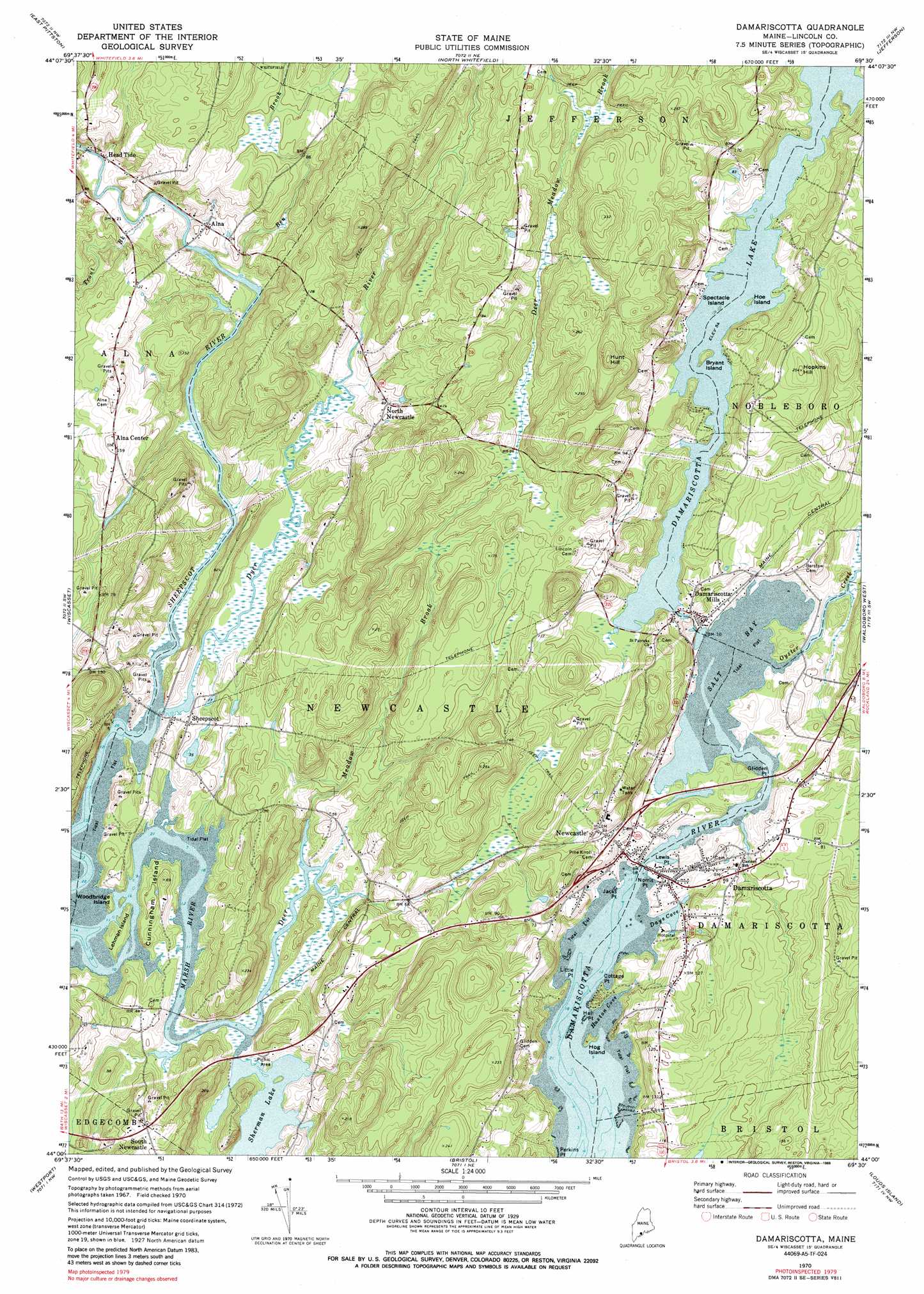
USGS Topo Quad 44069a5 - 1:24,000 scale
| Topo Map Name: | Damariscotta |
| USGS Topo Quad ID: | 44069a5 |
| Print Size: | ca. 21 1/4" wide x 27" high |
| Southeast Coordinates: | 44° N latitude / 69.5° W longitude |
| Map Center Coordinates: | 44.0625° N latitude / 69.5625° W longitude |
| U.S. State: | ME |
| Filename: | o44069a5.jpg |
| Download Map JPG Image: | Damariscotta topo map 1:24,000 scale |
| Map Type: | Topographic |
| Topo Series: | 7.5´ |
| Map Scale: | 1:24,000 |
| Source of Map Images: | United States Geological Survey (USGS) |
| Alternate Map Versions: |
Damariscotta ME 1970, updated 1974 Download PDF Buy paper map Damariscotta ME 1970, updated 1989 Download PDF Buy paper map Damariscotta ME 2000, updated 2001 Download PDF Buy paper map Damariscotta ME 2011 Download PDF Buy paper map Damariscotta ME 2014 Download PDF Buy paper map |
1:24,000 Topo Quads surrounding Damariscotta
Augusta |
Togus Pond |
Weeks Mills |
Razorville |
Washington |
Gardiner |
East Pittston |
North Whitefield |
Jefferson |
Union |
Richmond |
Wiscasset |
Damariscotta |
Waldoboro West |
Waldoboro East |
Bath |
Westport |
Bristol |
Louds Island |
Friendship |
Phippsburg |
Boothbay Harbor |
Pemaquid Point |
New Harbor |
Monhegan |
> Back to 44069a1 at 1:100,000 scale
> Back to 44068a1 at 1:250,000 scale
> Back to U.S. Topo Maps home
Damariscotta topo map: Gazetteer
Damariscotta: Bays
Days Cove elevation 9m 29′Huston Cove elevation 0m 0′
Salt Bay elevation 0m 0′
Damariscotta: Capes
Cottage Point elevation 7m 22′Glidden Point elevation 9m 29′
Hall Point elevation 14m 45′
Jacks Point elevation 4m 13′
Lewis Point elevation 6m 19′
Little Point elevation 7m 22′
Norris Point elevation 3m 9′
Perkins Point elevation 8m 26′
Damariscotta: Dams
Damariscotta Lake Dam elevation 16m 52′Head Tide Dam elevation 4m 13′
Marsh Bridge Dam elevation 1m 3′
Damariscotta: Islands
Bryant Island elevation 22m 72′Cunningham Island elevation 25m 82′
Hoe Island elevation 17m 55′
Hog Island elevation 7m 22′
Lehman Island elevation 4m 13′
Spectacle Island elevation 16m 52′
Woodbridge Island elevation 7m 22′
Damariscotta: Lakes
Damariscotta Lake elevation 16m 52′Damariscotta: Parks
Head Tide Historic District elevation 22m 72′Lonna Bunting Childrens Playground elevation 28m 91′
Main Street Historic District elevation 3m 9′
Sheepscot Historic District elevation 8m 26′
Damariscotta: Populated Places
Alna elevation 13m 42′Alna Center elevation 49m 160′
Damariscotta elevation 15m 49′
Damariscotta Mills elevation 7m 22′
Head Tide elevation 5m 16′
Newcastle elevation 9m 29′
North Newcastle elevation 28m 91′
Sheepscot elevation 10m 32′
South Newcastle elevation 34m 111′
Damariscotta: Reservoirs
Sheepscot River Reservoir elevation 4m 13′Sherman Lake elevation 1m 3′
Damariscotta: Streams
Ben Brook elevation 0m 0′Deer Meadow Brook elevation 0m 0′
Dyer River elevation 0m 0′
Marsh River elevation 0m 0′
Oyster Creek elevation 0m 0′
Trout Brook elevation 0m 0′
Damariscotta: Summits
Hopkins Hill elevation 76m 249′Hunt Hill elevation 106m 347′
Damariscotta digital topo map on disk
Buy this Damariscotta topo map showing relief, roads, GPS coordinates and other geographical features, as a high-resolution digital map file on DVD:
Maine, New Hampshire, Rhode Island & Eastern Massachusetts
Buy digital topo maps: Maine, New Hampshire, Rhode Island & Eastern Massachusetts