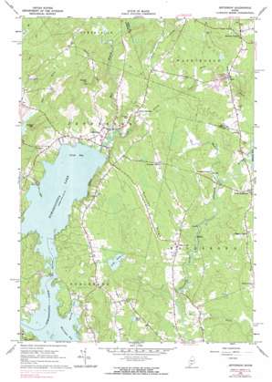
Jefferson Topo Map Maine
To zoom in, hover over the map of Jefferson
USGS Topo Quad 44069b4 - 1:24,000 scale
| Topo Map Name: | Jefferson |
| USGS Topo Quad ID: | 44069b4 |
| Print Size: | ca. 21 1/4" wide x 27" high |
| Southeast Coordinates: | 44.125° N latitude / 69.375° W longitude |
| Map Center Coordinates: | 44.1875° N latitude / 69.4375° W longitude |
| U.S. State: | ME |
| Filename: | o44069b4.jpg |
| Download Map JPG Image: | Jefferson topo map 1:24,000 scale |
| Map Type: | Topographic |
| Topo Series: | 7.5´ |
| Map Scale: | 1:24,000 |
| Source of Map Images: | United States Geological Survey (USGS) |
| Alternate Map Versions: |
Jefferson ME 1965, updated 1967 Download PDF Buy paper map Jefferson ME 1965, updated 1974 Download PDF Buy paper map Jefferson ME 1965, updated 1983 Download PDF Buy paper map Jefferson ME 1965, updated 1983 Download PDF Buy paper map Jefferson ME 2011 Download PDF Buy paper map Jefferson ME 2014 Download PDF Buy paper map |
1:24,000 Topo Quads surrounding Jefferson
> Back to 44069a1 at 1:100,000 scale
> Back to 44068a1 at 1:250,000 scale
> Back to U.S. Topo Maps home
Jefferson topo map: Gazetteer
Jefferson: Airports
Robinson Ridge Field elevation 74m 242′Jefferson: Bays
Great Bay elevation 16m 52′Morang Cove elevation 16m 52′
Jefferson: Gaps
The Narrows elevation 16m 52′Jefferson: Islands
Bird Feather Island elevation 16m 52′Jefferson: Lakes
Cooks Pond elevation 38m 124′Tobias Pond elevation 69m 226′
Jefferson: Parks
Damariscotta Lake State Park elevation 31m 101′Jefferson: Populated Places
Bogues Corner elevation 76m 249′Camp Wavus elevation 24m 78′
Flanders Corner elevation 74m 242′
Globe elevation 89m 291′
Jefferson elevation 23m 75′
Kennedy Corner elevation 95m 311′
North Jefferson elevation 49m 160′
North Waldoboro elevation 71m 232′
Orffs Corner elevation 53m 173′
Stickney Corner elevation 104m 341′
Jefferson: Ridges
Robinson Ridge elevation 70m 229′Jefferson: Streams
Benner Brook elevation 21m 68′Davis Stream elevation 16m 52′
Meadow Brook elevation 36m 118′
Pitcher Brook elevation 52m 170′
West Branch Davis Stream elevation 16m 52′
Jefferson: Summits
Bodge Hill elevation 104m 341′Eugley Hill elevation 107m 351′
Haskell Hill elevation 148m 485′
Jefferson digital topo map on disk
Buy this Jefferson topo map showing relief, roads, GPS coordinates and other geographical features, as a high-resolution digital map file on DVD:
Maine, New Hampshire, Rhode Island & Eastern Massachusetts
Buy digital topo maps: Maine, New Hampshire, Rhode Island & Eastern Massachusetts


