Gardiner Topo Map Maine
To zoom in, hover over the map of Gardiner
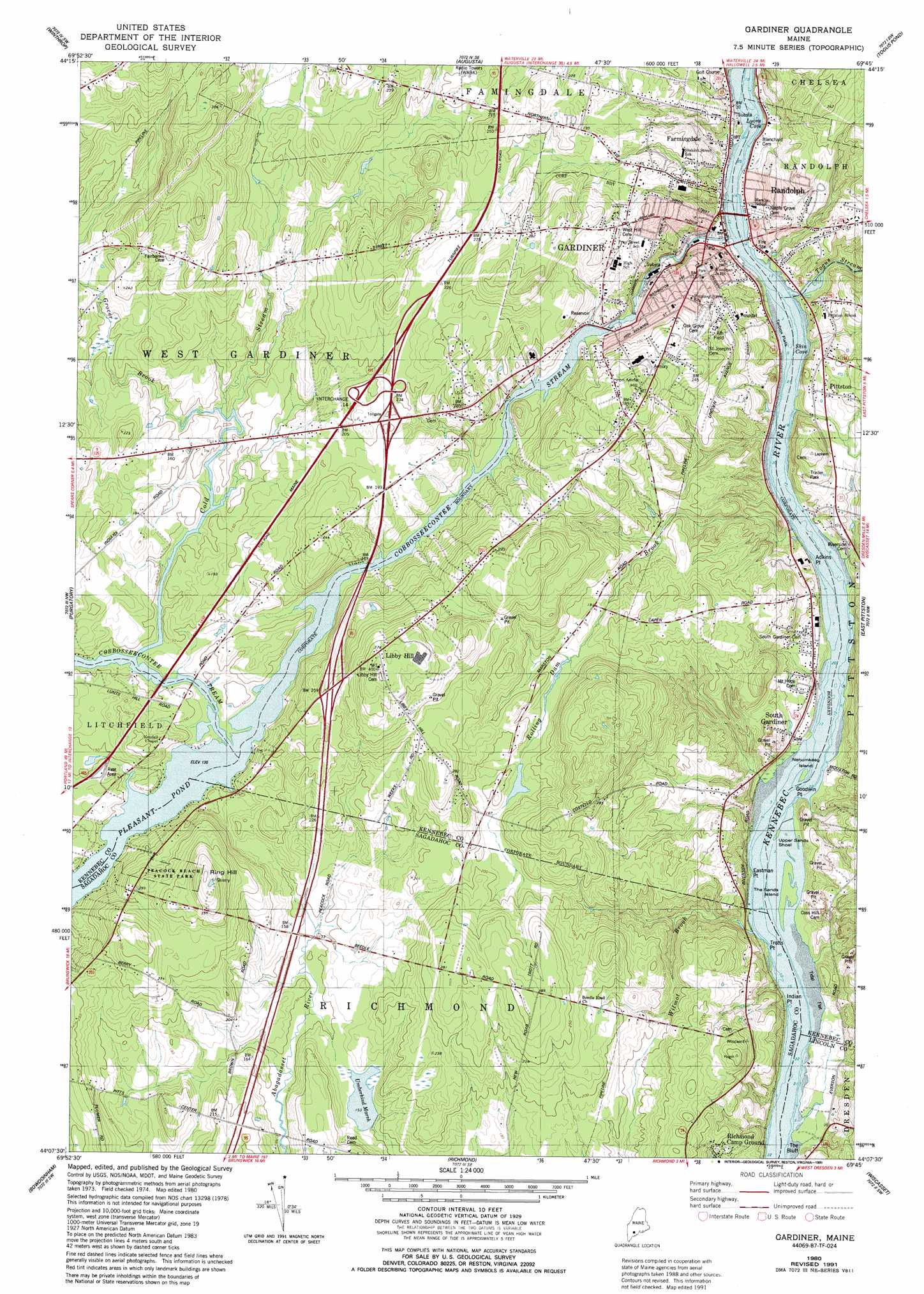
USGS Topo Quad 44069b7 - 1:24,000 scale
| Topo Map Name: | Gardiner |
| USGS Topo Quad ID: | 44069b7 |
| Print Size: | ca. 21 1/4" wide x 27" high |
| Southeast Coordinates: | 44.125° N latitude / 69.75° W longitude |
| Map Center Coordinates: | 44.1875° N latitude / 69.8125° W longitude |
| U.S. State: | ME |
| Filename: | o44069b7.jpg |
| Download Map JPG Image: | Gardiner topo map 1:24,000 scale |
| Map Type: | Topographic |
| Topo Series: | 7.5´ |
| Map Scale: | 1:24,000 |
| Source of Map Images: | United States Geological Survey (USGS) |
| Alternate Map Versions: |
Gardiner ME 1980, updated 1980 Download PDF Buy paper map Gardiner ME 1980, updated 1989 Download PDF Buy paper map Gardiner ME 1980, updated 1991 Download PDF Buy paper map Gardiner ME 2011 Download PDF Buy paper map Gardiner ME 2014 Download PDF Buy paper map |
1:24,000 Topo Quads surrounding Gardiner
Fayette |
Readfield |
Belgrade |
Vassalboro |
China Lake |
Wayne |
Winthrop |
Augusta |
Togus Pond |
Weeks Mills |
Monmouth |
Purgatory |
Gardiner |
East Pittston |
North Whitefield |
Lisbon Falls North |
Bowdoinham |
Richmond |
Wiscasset |
Damariscotta |
Lisbon Falls South |
Brunswick |
Bath |
Westport |
Bristol |
> Back to 44069a1 at 1:100,000 scale
> Back to 44068a1 at 1:250,000 scale
> Back to U.S. Topo Maps home
Gardiner topo map: Gazetteer
Gardiner: Bars
Farmingdale Shoal elevation 0m 0′Greens Ledge elevation 0m 0′
Hathorn Rock elevation 0m 0′
Upper Sands Shoal elevation 0m 0′
Gardiner: Bays
Lyons Cove elevation 0m 0′Skin Cove elevation 0m 0′
Gardiner: Capes
Adkins Point elevation 15m 49′Eastman Point elevation 0m 0′
Goodwin Point elevation 18m 59′
Indian Point elevation 9m 29′
Trotts Point elevation 3m 9′
Gardiner: Cliffs
The Bluff elevation 17m 55′Gardiner: Crossings
Interchange 14 elevation 65m 213′Gardiner: Dams
American Tissue Dam elevation 36m 118′New Mills Dam elevation 41m 134′
Gardiner: Flats
Tarbox Flats elevation 0m 0′Gardiner: Islands
Nehumkeag Island elevation 0m 0′The Sands Island elevation 1m 3′
Gardiner: Lakes
Pleasant Pond elevation 41m 134′Umberhind Marsh elevation 46m 150′
Gardiner: Parks
Peacock Beach State Park elevation 79m 259′Gardiner: Populated Places
Farmingdale elevation 16m 52′Gardiner elevation 7m 22′
Libby Hill elevation 114m 374′
Nehumkeag (historical) elevation 7m 22′
Pittston elevation 25m 82′
Randolph elevation 6m 19′
South Gardiner elevation 12m 39′
Gardiner: Reservoirs
Cobbosseecontee Stream Reservoir elevation 41m 134′Pleasant Pond elevation 42m 137′
Gardiner: Streams
Cobbosseecontee Stream elevation 0m 0′Cold Stream elevation 41m 134′
Grover Brook elevation 41m 134′
Morton Brook elevation 0m 0′
Rolling Dam Brook elevation 6m 19′
Togus Stream elevation 1m 3′
Wilmot Brook elevation 0m 0′
Gardiner: Summits
Iron Mine Hill elevation 92m 301′Ring Hill elevation 116m 380′
Gardiner digital topo map on disk
Buy this Gardiner topo map showing relief, roads, GPS coordinates and other geographical features, as a high-resolution digital map file on DVD:
Maine, New Hampshire, Rhode Island & Eastern Massachusetts
Buy digital topo maps: Maine, New Hampshire, Rhode Island & Eastern Massachusetts