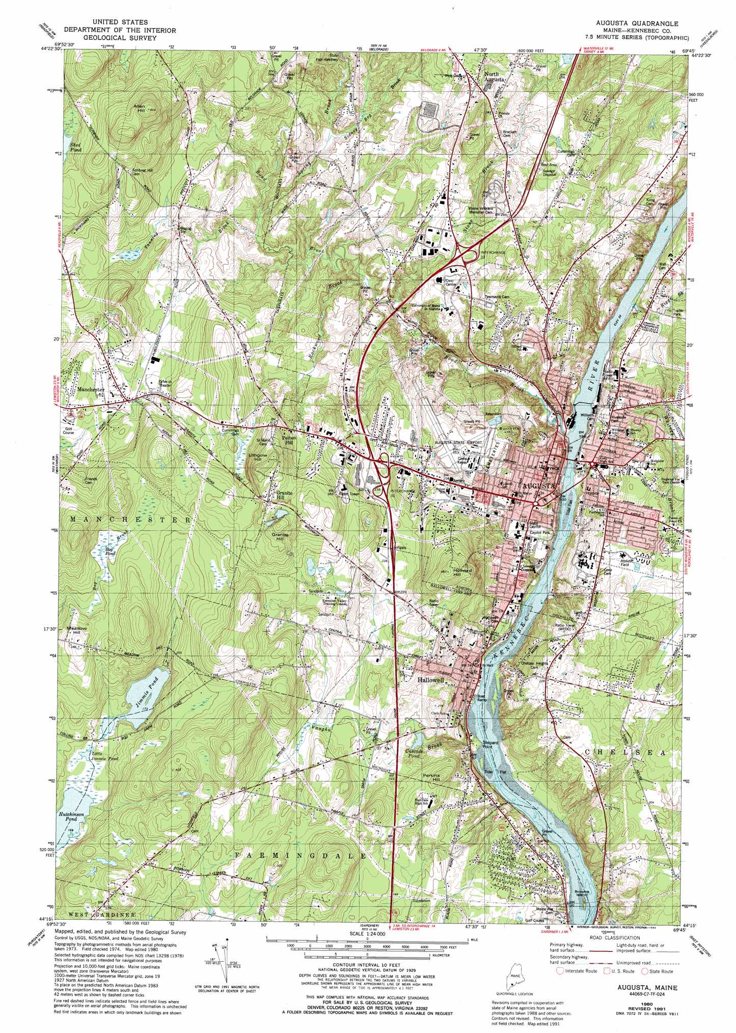
Augusta Topo Map Maine
To zoom in, hover over the map of Augusta
USGS Topo Quad 44069c7 - 1:24,000 scale
| Topo Map Name: | Augusta |
| USGS Topo Quad ID: | 44069c7 |
| Print Size: | ca. 21 1/4" wide x 27" high |
| Southeast Coordinates: | 44.25° N latitude / 69.75° W longitude |
| Map Center Coordinates: | 44.3125° N latitude / 69.8125° W longitude |
| U.S. State: | ME |
| Filename: | o44069c7.jpg |
| Download Map JPG Image: | Augusta topo map 1:24,000 scale |
| Map Type: | Topographic |
| Topo Series: | 7.5´ |
| Map Scale: | 1:24,000 |
| Source of Map Images: | United States Geological Survey (USGS) |
| Alternate Map Versions: |
Augusta ME 1980, updated 1980 Download PDF Buy paper map Augusta ME 1980, updated 1992 Download PDF Buy paper map Augusta ME 2011 Download PDF Buy paper map Augusta ME 2014 Download PDF Buy paper map |
1:24,000 Topo Quads surrounding Augusta
Farmington Falls |
Belgrade Lakes |
Rome |
Waterville |
Fairfield |
Fayette |
Readfield |
Belgrade |
Vassalboro |
China Lake |
Wayne |
Winthrop |
Augusta |
Togus Pond |
Weeks Mills |
Monmouth |
Purgatory |
Gardiner |
East Pittston |
North Whitefield |
Lisbon Falls North |
Bowdoinham |
Richmond |
Wiscasset |
Damariscotta |
> Back to 44069a1 at 1:100,000 scale
> Back to 44068a1 at 1:250,000 scale
> Back to U.S. Topo Maps home
Augusta topo map: Gazetteer
Augusta: Airports
Augusta Seaplane Base elevation 0m 0′Augusta State Airport elevation 108m 354′
Augusta: Bars
Britts Shoal elevation 0m 0′Hinkley Shoal elevation 0m 0′
Augusta: Capes
Shepard Point elevation 0m 0′Augusta: Crossings
Interchange 15 elevation 72m 236′Augusta: Dams
Edwards Dam (historical) elevation 3m 9′Hallowell Recreation Pond Dam elevation 93m 305′
Vaughn Brook Dam elevation 57m 187′
Augusta: Islands
Browns Island elevation 5m 16′Augusta: Lakes
Bog Pond elevation 89m 291′Cascade Pond elevation 57m 187′
Hutchinson Pond elevation 51m 167′
Jimmie Pond elevation 52m 170′
Little Jimmie Pond elevation 52m 170′
Augusta: Parks
Capitol Park elevation 29m 95′Augusta: Populated Places
Augusta elevation 38m 124′Granite Hill elevation 129m 423′
Hallowell elevation 12m 39′
Manchester elevation 65m 213′
North Augusta elevation 92m 301′
Pelton Hill elevation 103m 337′
Augusta: Reservoirs
Hallowell Recreation Pond elevation 93m 305′Kennebec River Reservoir elevation 3m 9′
Vaughn Pond elevation 63m 206′
Augusta: Streams
Bond Brook elevation 6m 19′Riggs Branch elevation 8m 26′
Rockwood Brook elevation 34m 111′
Sidney Bog Brook elevation 48m 157′
Spring Brook elevation 41m 134′
Stone Brook elevation 32m 104′
Tanning Brook elevation 39m 127′
Vaughn Brook elevation 7m 22′
Whitney Brook elevation 8m 26′
Augusta: Summits
Allen Hill elevation 193m 633′Burnt Hill elevation 116m 380′
Granite Hill elevation 158m 518′
Howard Hill elevation 147m 482′
Hunts Hill elevation 74m 242′
Lithgow Hill elevation 164m 538′
Meadow Hill elevation 117m 383′
Perkins Hill elevation 103m 337′
Augusta digital topo map on disk
Buy this Augusta topo map showing relief, roads, GPS coordinates and other geographical features, as a high-resolution digital map file on DVD:
Maine, New Hampshire, Rhode Island & Eastern Massachusetts
Buy digital topo maps: Maine, New Hampshire, Rhode Island & Eastern Massachusetts