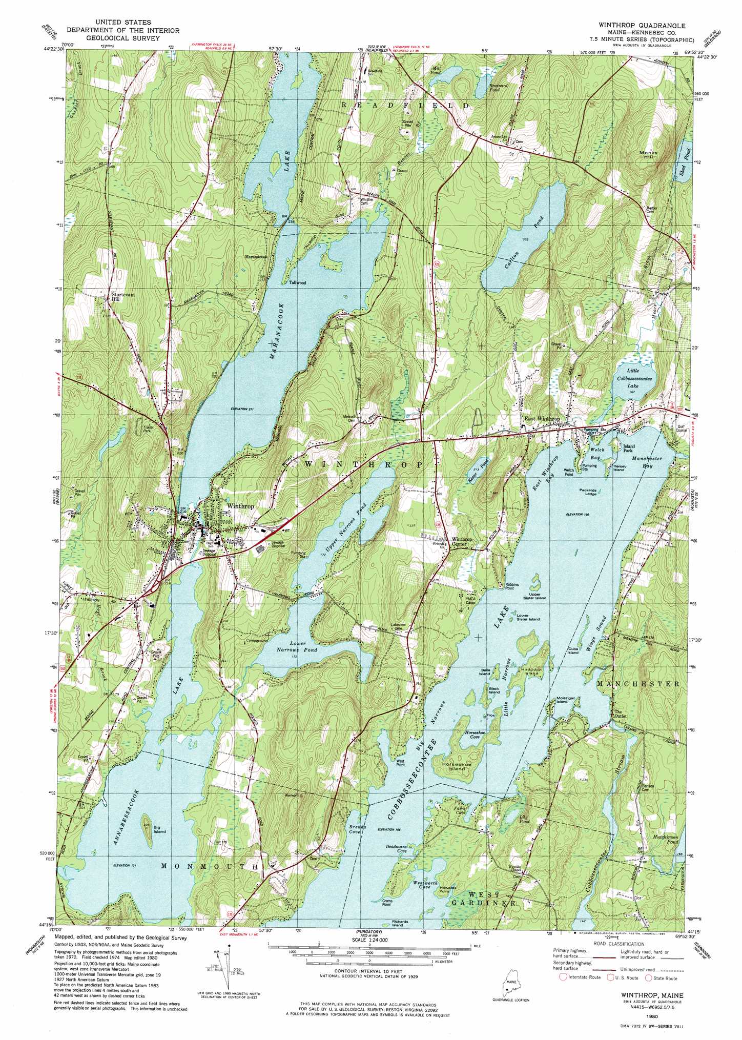
Winthrop Topo Map Maine
To zoom in, hover over the map of Winthrop
USGS Topo Quad 44069c8 - 1:24,000 scale
| Topo Map Name: | Winthrop |
| USGS Topo Quad ID: | 44069c8 |
| Print Size: | ca. 21 1/4" wide x 27" high |
| Southeast Coordinates: | 44.25° N latitude / 69.875° W longitude |
| Map Center Coordinates: | 44.3125° N latitude / 69.9375° W longitude |
| U.S. State: | ME |
| Filename: | o44069c8.jpg |
| Download Map JPG Image: | Winthrop topo map 1:24,000 scale |
| Map Type: | Topographic |
| Topo Series: | 7.5´ |
| Map Scale: | 1:24,000 |
| Source of Map Images: | United States Geological Survey (USGS) |
| Alternate Map Versions: |
Winthrop ME 1980, updated 1980 Download PDF Buy paper map Winthrop ME 2000, updated 2001 Download PDF Buy paper map Winthrop ME 2011 Download PDF Buy paper map Winthrop ME 2014 Download PDF Buy paper map |
1:24,000 Topo Quads surrounding Winthrop
Wilton |
Farmington Falls |
Belgrade Lakes |
Rome |
Waterville |
Livermore Falls |
Fayette |
Readfield |
Belgrade |
Vassalboro |
Turner Center |
Wayne |
Winthrop |
Augusta |
Togus Pond |
Lake Auburn East |
Monmouth |
Purgatory |
Gardiner |
East Pittston |
Lewiston |
Lisbon Falls North |
Bowdoinham |
Richmond |
Wiscasset |
> Back to 44069a1 at 1:100,000 scale
> Back to 44068a1 at 1:250,000 scale
> Back to U.S. Topo Maps home
Winthrop topo map: Gazetteer
Winthrop: Airports
Fowler Seaplane Base elevation 52m 170′Lakeside Marina Seaplane Base elevation 51m 167′
Winthrop: Bars
Packards Ledge elevation 51m 167′Winthrop: Capes
Crams Point elevation 54m 177′Robbins Point elevation 62m 203′
Welch Point elevation 53m 173′
West Point elevation 56m 183′
Winthrop: Dams
Carleton Pond Dam elevation 101m 331′Cobbosseecontee Lake Dam elevation 51m 167′
Maranacook Lake Upper Dam elevation 64m 209′
Mill Pond Dam elevation 79m 259′
Winthrop: Islands
Belle Island elevation 54m 177′Big Island elevation 68m 223′
Black Island elevation 53m 173′
Cuba Island elevation 52m 170′
Frog Island elevation 58m 190′
Hersey Island elevation 52m 170′
Hodgdon Island elevation 54m 177′
Horseshoe Island elevation 62m 203′
Lower Sister Island elevation 51m 167′
Molazigan Island elevation 56m 183′
Richards Island elevation 51m 167′
Upper Sister Island elevation 51m 167′
Winthrop: Lakes
Annabessacook Lake elevation 52m 170′Brainard Pond elevation 81m 265′
Kezar Pond elevation 65m 213′
Lily Pond elevation 51m 167′
Little Cobbosseecontee Lake elevation 51m 167′
Lower Narrows Pond elevation 52m 170′
Shed Pond elevation 112m 367′
Upper Narrows Pond elevation 52m 170′
Winthrop: Populated Places
East Winthrop elevation 58m 190′Island Park elevation 51m 167′
Maranacook elevation 73m 239′
Sturtevant Hill elevation 168m 551′
Tallwood elevation 68m 223′
Winthrop elevation 70m 229′
Winthrop Center elevation 80m 262′
Winthrop: Reservoirs
Carleton Pond elevation 101m 331′Cobbosseecontee Lake elevation 51m 167′
Maranacook Lake elevation 64m 209′
Mill Pond elevation 81m 265′
Winthrop: Streams
Beaver Brook elevation 64m 209′Bog Brook elevation 47m 154′
Hoyt Brook elevation 52m 170′
Kezar Brook elevation 53m 173′
Mears Brook elevation 51m 167′
Wilson Stream elevation 52m 170′
Winthrop: Summits
Monks Hill elevation 203m 666′Winthrop digital topo map on disk
Buy this Winthrop topo map showing relief, roads, GPS coordinates and other geographical features, as a high-resolution digital map file on DVD:
Maine, New Hampshire, Rhode Island & Eastern Massachusetts
Buy digital topo maps: Maine, New Hampshire, Rhode Island & Eastern Massachusetts