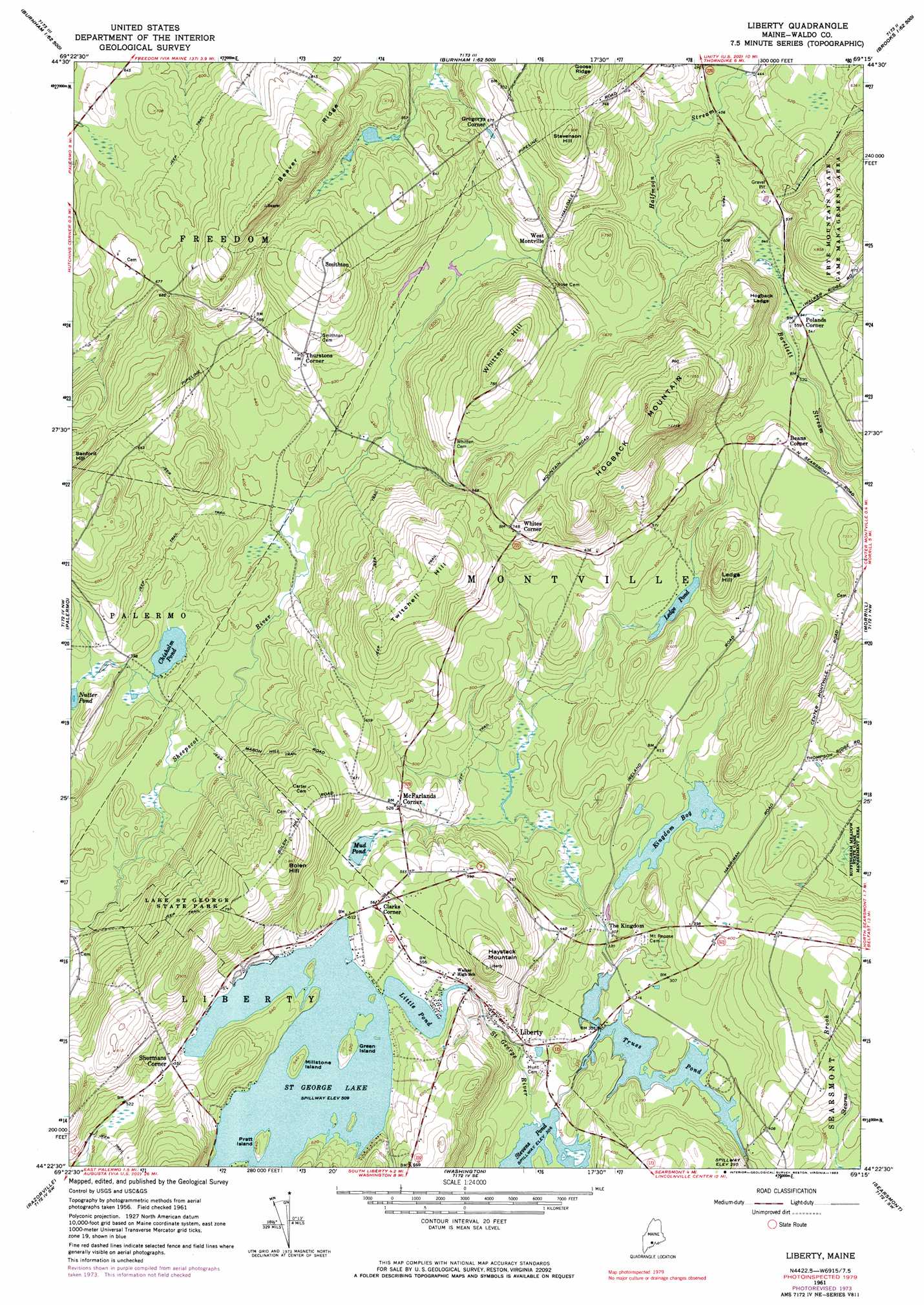
Liberty Topo Map Maine
To zoom in, hover over the map of Liberty
USGS Topo Quad 44069d3 - 1:24,000 scale
| Topo Map Name: | Liberty |
| USGS Topo Quad ID: | 44069d3 |
| Print Size: | ca. 21 1/4" wide x 27" high |
| Southeast Coordinates: | 44.375° N latitude / 69.25° W longitude |
| Map Center Coordinates: | 44.4375° N latitude / 69.3125° W longitude |
| U.S. State: | ME |
| Filename: | o44069d3.jpg |
| Download Map JPG Image: | Liberty topo map 1:24,000 scale |
| Map Type: | Topographic |
| Topo Series: | 7.5´ |
| Map Scale: | 1:24,000 |
| Source of Map Images: | United States Geological Survey (USGS) |
| Alternate Map Versions: |
Liberty ME 1961, updated 1964 Download PDF Buy paper map Liberty ME 1961, updated 1971 Download PDF Buy paper map Liberty ME 1961, updated 1974 Download PDF Buy paper map Liberty ME 1961, updated 1983 Download PDF Buy paper map Liberty ME 2011 Download PDF Buy paper map Liberty ME 2014 Download PDF Buy paper map |
1:24,000 Topo Quads surrounding Liberty
Clinton |
Burnham |
Unity Pond |
Dixmont |
East Dixmont |
Fairfield |
Albion |
Unity |
Brooks West |
Brooks East |
China Lake |
Palermo |
Liberty |
Morrill |
Belfast |
Weeks Mills |
Razorville |
Washington |
Searsmont |
Lincolnville |
North Whitefield |
Jefferson |
Union |
West Rockport |
Camden |
> Back to 44069a1 at 1:100,000 scale
> Back to 44068a1 at 1:250,000 scale
> Back to U.S. Topo Maps home
Liberty topo map: Gazetteer
Liberty: Cliffs
Hogback Ledge elevation 215m 705′Liberty: Dams
Kingdom Bog Dam elevation 106m 347′Saint George Lake Dam elevation 155m 508′
Stevens Pond Dam elevation 93m 305′
Trues Pond Dam elevation 87m 285′
Liberty: Islands
Green Island elevation 162m 531′Millstone Island elevation 166m 544′
Pratt Island elevation 164m 538′
Liberty: Lakes
Chisholm Pond elevation 108m 354′Ledge Pond elevation 143m 469′
Little Pond elevation 155m 508′
Mud Pond elevation 145m 475′
Nutter Pond elevation 123m 403′
Liberty: Parks
Lake Saint George State Park elevation 209m 685′Liberty: Populated Places
Beans Corner elevation 195m 639′Clarks Corner elevation 170m 557′
Gregorys Corner elevation 205m 672′
Liberty elevation 116m 380′
McFarlands Corner elevation 160m 524′
Polands Corner elevation 166m 544′
Shermans Corner elevation 168m 551′
Smithton elevation 238m 780′
Thurstons Corner elevation 181m 593′
West Montville elevation 169m 554′
Whites Corner elevation 224m 734′
Liberty: Reservoirs
Kingdom Bog elevation 106m 347′Saint George Lake elevation 155m 508′
Stevens Pond elevation 93m 305′
Trues Pond elevation 87m 285′
Liberty: Ridges
Beaver Ridge elevation 289m 948′Liberty: Summits
Bolen Hill elevation 267m 875′Haystack Mountain elevation 253m 830′
Hogback Mountain elevation 327m 1072′
Ledge Hill elevation 226m 741′
Stevenson Hill elevation 273m 895′
Twitchell Hill elevation 260m 853′
Whitten Hill elevation 259m 849′
Liberty digital topo map on disk
Buy this Liberty topo map showing relief, roads, GPS coordinates and other geographical features, as a high-resolution digital map file on DVD:
Maine, New Hampshire, Rhode Island & Eastern Massachusetts
Buy digital topo maps: Maine, New Hampshire, Rhode Island & Eastern Massachusetts