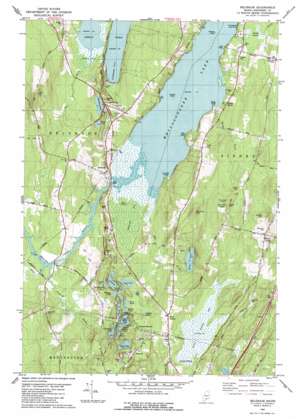
Belgrade Topo Map Maine
To zoom in, hover over the map of Belgrade
USGS Topo Quad 44069d7 - 1:24,000 scale
| Topo Map Name: | Belgrade |
| USGS Topo Quad ID: | 44069d7 |
| Print Size: | ca. 21 1/4" wide x 27" high |
| Southeast Coordinates: | 44.375° N latitude / 69.75° W longitude |
| Map Center Coordinates: | 44.4375° N latitude / 69.8125° W longitude |
| U.S. State: | ME |
| Filename: | o44069d7.jpg |
| Download Map JPG Image: | Belgrade topo map 1:24,000 scale |
| Map Type: | Topographic |
| Topo Series: | 7.5´ |
| Map Scale: | 1:24,000 |
| Source of Map Images: | United States Geological Survey (USGS) |
| Alternate Map Versions: |
Belgrade ME 1980, updated 1980 Download PDF Buy paper map Belgrade ME 1980, updated 1980 Download PDF Buy paper map Belgrade ME 2011 Download PDF Buy paper map Belgrade ME 2014 Download PDF Buy paper map |
1:24,000 Topo Quads surrounding Belgrade
> Back to 44069a1 at 1:100,000 scale
> Back to 44068a1 at 1:250,000 scale
> Back to U.S. Topo Maps home
Belgrade topo map: Gazetteer
Belgrade: Airports
Sunny Hill Airport elevation 101m 331′Belgrade: Islands
Birch Island elevation 72m 236′Greeley Island elevation 71m 232′
Midway Island elevation 71m 232′
Belgrade: Lakes
Doctors Pond elevation 83m 272′Fairbanks Pond elevation 81m 265′
Gould Pond elevation 82m 269′
Hamilton Pond elevation 79m 259′
Joe Pond elevation 82m 269′
Lily Bay elevation 83m 272′
Penney Pond elevation 81m 265′
Silver Lake elevation 81m 265′
Stuart Pond elevation 85m 278′
Tyler Pond elevation 79m 259′
Ward Pond elevation 100m 328′
Belgrade: Populated Places
Bacons Corner elevation 84m 275′Bangs Beach elevation 80m 262′
Belgrade elevation 76m 249′
Summerhaven elevation 98m 321′
West Sidney elevation 118m 387′
Belgrade: Streams
Belgrade Stream elevation 71m 232′Bog Brook elevation 79m 259′
Hoyt Brook elevation 71m 232′
Sanford Brook elevation 73m 239′
Belgrade: Summits
Lord Hill elevation 165m 541′Quaker Hill elevation 179m 587′
Ricker Hill elevation 134m 439′
Belgrade: Swamps
Austin Bog elevation 76m 249′Great Sidney Bog elevation 90m 295′
Belgrade digital topo map on disk
Buy this Belgrade topo map showing relief, roads, GPS coordinates and other geographical features, as a high-resolution digital map file on DVD:
Maine, New Hampshire, Rhode Island & Eastern Massachusetts
Buy digital topo maps: Maine, New Hampshire, Rhode Island & Eastern Massachusetts


