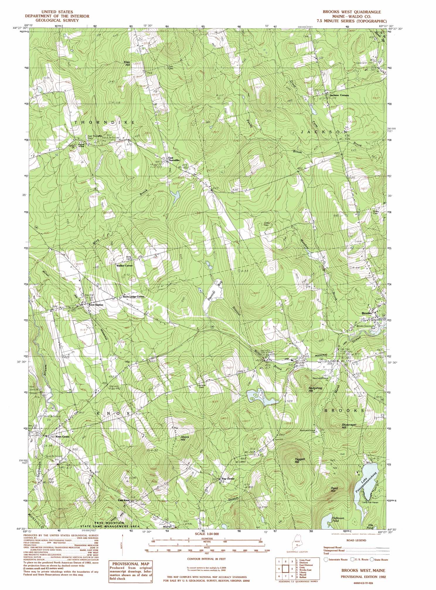
Brooks West Topo Map Maine
To zoom in, hover over the map of Brooks West
USGS Topo Quad 44069e2 - 1:24,000 scale
| Topo Map Name: | Brooks West |
| USGS Topo Quad ID: | 44069e2 |
| Print Size: | ca. 21 1/4" wide x 27" high |
| Southeast Coordinates: | 44.5° N latitude / 69.125° W longitude |
| Map Center Coordinates: | 44.5625° N latitude / 69.1875° W longitude |
| U.S. State: | ME |
| Filename: | o44069e2.jpg |
| Download Map JPG Image: | Brooks West topo map 1:24,000 scale |
| Map Type: | Topographic |
| Topo Series: | 7.5´ |
| Map Scale: | 1:24,000 |
| Source of Map Images: | United States Geological Survey (USGS) |
| Alternate Map Versions: |
Brooks SW ME 1975, updated 1980 Download PDF Buy paper map Brooks West ME 1982, updated 1983 Download PDF Buy paper map Brooks West ME 2011 Download PDF Buy paper map Brooks West ME 2014 Download PDF Buy paper map |
1:24,000 Topo Quads surrounding Brooks West
Pittsfield |
Newport |
Plymouth |
Carmel |
Hermon |
Burnham |
Unity Pond |
Dixmont |
East Dixmont |
Snow Mountain |
Albion |
Unity |
Brooks West |
Brooks East |
Mount Waldo |
Palermo |
Liberty |
Morrill |
Belfast |
Searsport |
Razorville |
Washington |
Searsmont |
Lincolnville |
Islesboro |
> Back to 44069e1 at 1:100,000 scale
> Back to 44068a1 at 1:250,000 scale
> Back to U.S. Topo Maps home
Brooks West topo map: Gazetteer
Brooks West: Lakes
Halfmoon Pond elevation 108m 354′Lake Passagassawakeag elevation 94m 308′
Brooks West: Populated Places
East Knox elevation 217m 711′East Thorndike elevation 162m 531′
Knox Center elevation 105m 344′
Knox Ledge Corner elevation 171m 561′
Ray Corner elevation 160m 524′
Walker Corner elevation 190m 623′
Brooks West: Streams
Meadow Brook elevation 115m 377′Penny Brook elevation 132m 433′
Stantial Brook elevation 116m 380′
Wing Brook elevation 78m 255′
Brooks West: Summits
Aborn Hill elevation 304m 997′Files Hill elevation 270m 885′
Hedgehog Hill elevation 168m 551′
Pond Hill elevation 248m 813′
Skyscraper Hill elevation 205m 672′
Taggert Hill elevation 249m 816′
Brooks West: Swamps
Stantial Bog elevation 143m 469′Brooks West digital topo map on disk
Buy this Brooks West topo map showing relief, roads, GPS coordinates and other geographical features, as a high-resolution digital map file on DVD:
Maine, New Hampshire, Rhode Island & Eastern Massachusetts
Buy digital topo maps: Maine, New Hampshire, Rhode Island & Eastern Massachusetts