Unity Pond Topo Map Maine
To zoom in, hover over the map of Unity Pond
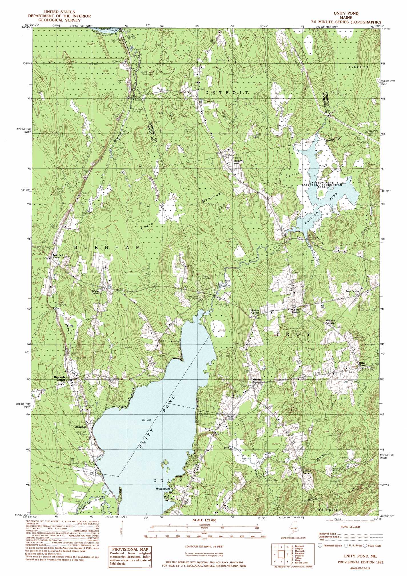
USGS Topo Quad 44069f3 - 1:24,000 scale
| Topo Map Name: | Unity Pond |
| USGS Topo Quad ID: | 44069f3 |
| Print Size: | ca. 21 1/4" wide x 27" high |
| Southeast Coordinates: | 44.625° N latitude / 69.25° W longitude |
| Map Center Coordinates: | 44.6875° N latitude / 69.3125° W longitude |
| U.S. State: | ME |
| Filename: | o44069f3.jpg |
| Download Map JPG Image: | Unity Pond topo map 1:24,000 scale |
| Map Type: | Topographic |
| Topo Series: | 7.5´ |
| Map Scale: | 1:24,000 |
| Source of Map Images: | United States Geological Survey (USGS) |
| Alternate Map Versions: |
Burnham NE ME 1975, updated 1980 Download PDF Buy paper map Unity Pond ME 1982, updated 1983 Download PDF Buy paper map Unity Pond ME 1982, updated 1983 Download PDF Buy paper map Unity Pond ME 2011 Download PDF Buy paper map Unity Pond ME 2014 Download PDF Buy paper map |
1:24,000 Topo Quads surrounding Unity Pond
Harmony |
Hartland |
Corinna |
Stetson |
West Corinth |
Canaan |
Pittsfield |
Newport |
Plymouth |
Carmel |
Clinton |
Burnham |
Unity Pond |
Dixmont |
East Dixmont |
Fairfield |
Albion |
Unity |
Brooks West |
Brooks East |
China Lake |
Palermo |
Liberty |
Morrill |
Belfast |
> Back to 44069e1 at 1:100,000 scale
> Back to 44068a1 at 1:250,000 scale
> Back to U.S. Topo Maps home
Unity Pond topo map: Gazetteer
Unity Pond: Dams
Carlton Pond Dam elevation 63m 206′Unity Pond: Lakes
Unity Pond elevation 53m 173′Unity Pond: Populated Places
Cooks Corner elevation 85m 278′Dodge Corner elevation 91m 298′
Gerrish Corner elevation 99m 324′
Greens Corner elevation 98m 321′
Hales Corner elevation 116m 380′
Mitchell Corner elevation 125m 410′
Oakwood elevation 62m 203′
Reynolds Corner elevation 64m 209′
Smarts Corner elevation 104m 341′
Troy Center elevation 100m 328′
Twitchell Corner elevation 65m 213′
Windemere elevation 53m 173′
Unity Pond: Reservoirs
Carlton Pond elevation 63m 206′Unity Pond: Streams
Beartrap Brook elevation 52m 170′Bithers Brook elevation 54m 177′
Bog Brook elevation 78m 255′
Carlton Stream elevation 53m 173′
Meadow Brook elevation 53m 173′
Sandy Stream elevation 53m 173′
Shaw Brook elevation 62m 203′
Unity Pond: Summits
Beech Hill elevation 105m 344′Unity Pond: Swamps
Carlton Bog elevation 64m 209′Chain Meadows elevation 66m 216′
Unity Pond digital topo map on disk
Buy this Unity Pond topo map showing relief, roads, GPS coordinates and other geographical features, as a high-resolution digital map file on DVD:
Maine, New Hampshire, Rhode Island & Eastern Massachusetts
Buy digital topo maps: Maine, New Hampshire, Rhode Island & Eastern Massachusetts