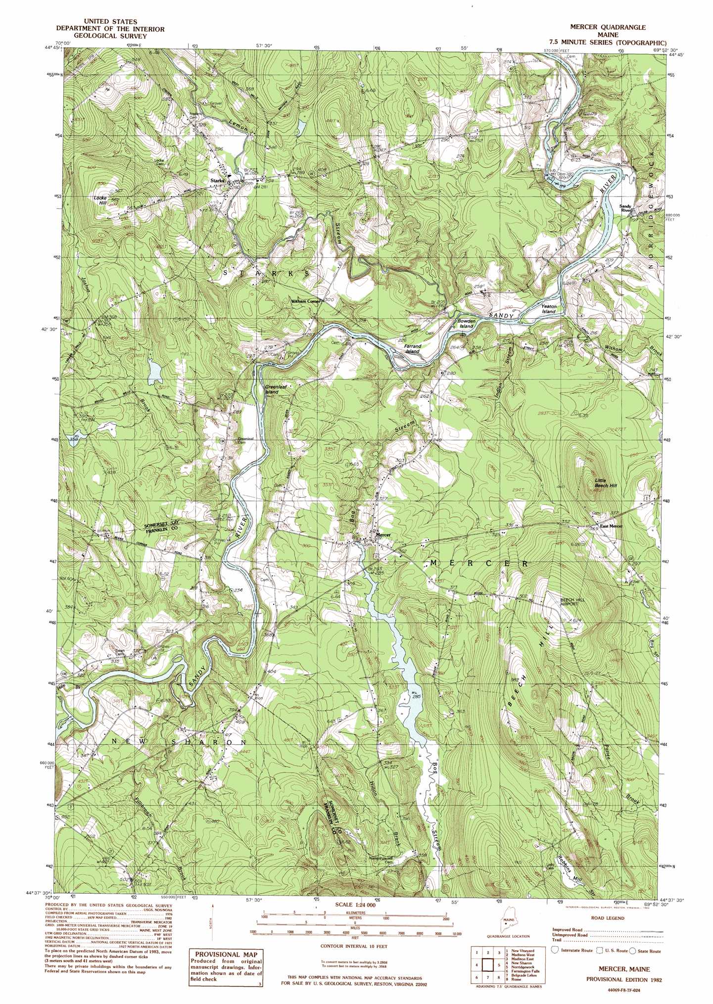
Mercer Topo Map Maine
To zoom in, hover over the map of Mercer
USGS Topo Quad 44069f8 - 1:24,000 scale
| Topo Map Name: | Mercer |
| USGS Topo Quad ID: | 44069f8 |
| Print Size: | ca. 21 1/4" wide x 27" high |
| Southeast Coordinates: | 44.625° N latitude / 69.875° W longitude |
| Map Center Coordinates: | 44.6875° N latitude / 69.9375° W longitude |
| U.S. State: | ME |
| Filename: | o44069f8.jpg |
| Download Map JPG Image: | Mercer topo map 1:24,000 scale |
| Map Type: | Topographic |
| Topo Series: | 7.5´ |
| Map Scale: | 1:24,000 |
| Source of Map Images: | United States Geological Survey (USGS) |
| Alternate Map Versions: |
Norridgewock NW ME 1975, updated 1980 Download PDF Buy paper map Mercer ME 1982, updated 1983 Download PDF Buy paper map Mercer ME 2011 Download PDF Buy paper map Mercer ME 2014 Download PDF Buy paper map |
1:24,000 Topo Quads surrounding Mercer
Kingfield |
New Portland |
Embden Pond |
Solon |
Arbens |
Strong |
New Vineyard |
Madison West |
Madison East |
Skowhegan |
Farmington |
New Sharon |
Mercer |
Norridgewock |
Hinckley |
Wilton |
Farmington Falls |
Belgrade Lakes |
Rome |
Waterville |
Livermore Falls |
Fayette |
Readfield |
Belgrade |
Vassalboro |
> Back to 44069e1 at 1:100,000 scale
> Back to 44068a1 at 1:250,000 scale
> Back to U.S. Topo Maps home
Mercer topo map: Gazetteer
Mercer: Airports
Beech Hill Airport elevation 190m 623′Mercer: Dams
Mercer Bog Dam elevation 84m 275′Sandy River Dam elevation 52m 170′
Mercer: Islands
Bowden Island elevation 61m 200′Farrand Island elevation 60m 196′
Yeaton Island elevation 58m 190′
Mercer: Populated Places
East Mercer elevation 101m 331′Mercer elevation 89m 291′
Sandy River elevation 56m 183′
Starks elevation 78m 255′
Witham Corner elevation 91m 298′
Mercer: Reservoirs
Mercer Bog elevation 86m 282′Sandy River Reservoir elevation 52m 170′
Mercer: Streams
Bog Stream elevation 57m 187′Fillibrown Brook elevation 76m 249′
Hale Brook elevation 84m 275′
Hilton Brook elevation 95m 311′
Indian Stream elevation 58m 190′
Josiah Brook elevation 64m 209′
Lemon Stream elevation 60m 196′
Witham Brook elevation 74m 242′
Mercer: Summits
Beech Hill elevation 177m 580′Little Beech Hill elevation 114m 374′
Mercer digital topo map on disk
Buy this Mercer topo map showing relief, roads, GPS coordinates and other geographical features, as a high-resolution digital map file on DVD:
Maine, New Hampshire, Rhode Island & Eastern Massachusetts
Buy digital topo maps: Maine, New Hampshire, Rhode Island & Eastern Massachusetts