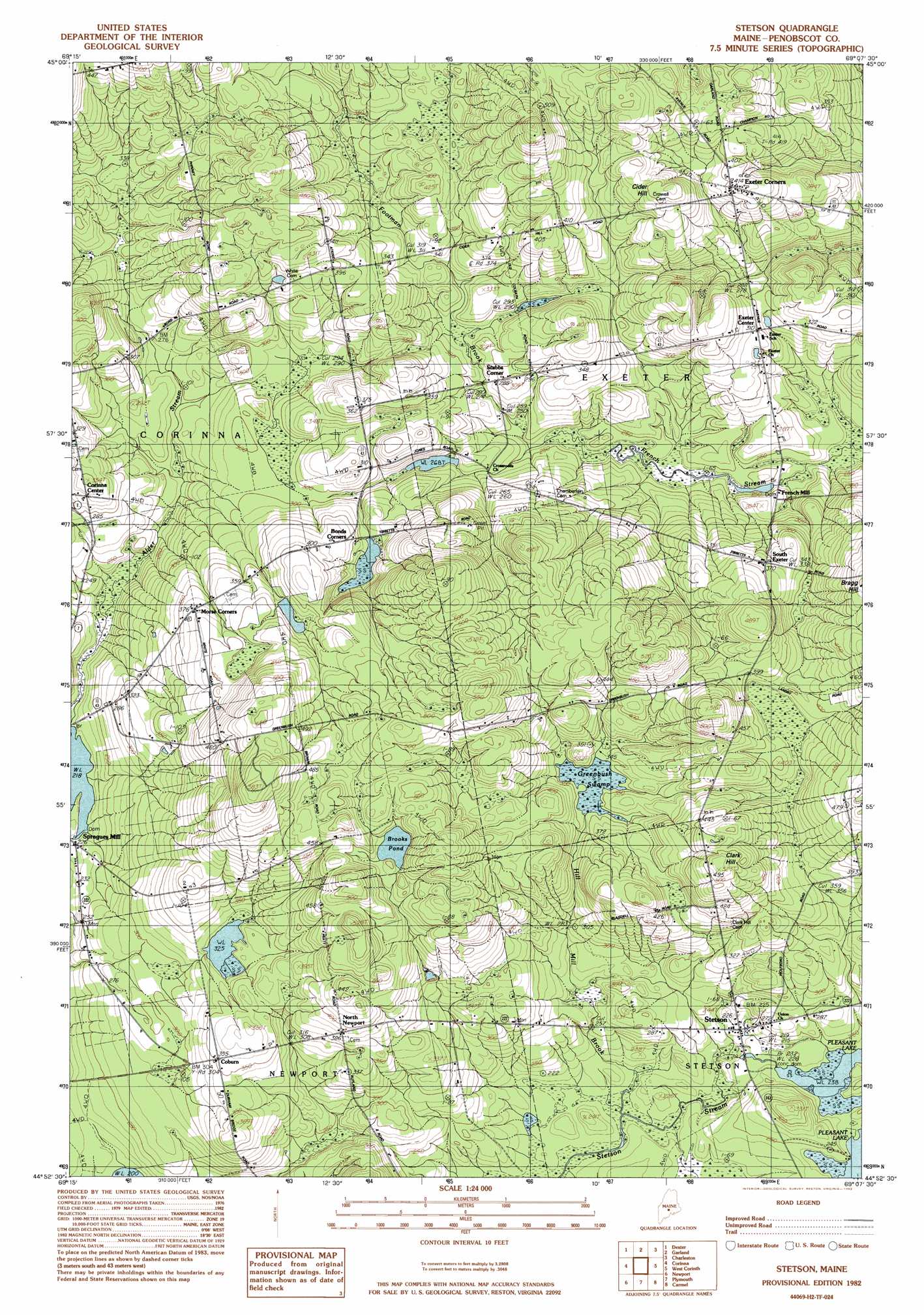
Stetson Topo Map Maine
To zoom in, hover over the map of Stetson
USGS Topo Quad 44069h2 - 1:24,000 scale
| Topo Map Name: | Stetson |
| USGS Topo Quad ID: | 44069h2 |
| Print Size: | ca. 21 1/4" wide x 27" high |
| Southeast Coordinates: | 44.875° N latitude / 69.125° W longitude |
| Map Center Coordinates: | 44.9375° N latitude / 69.1875° W longitude |
| U.S. State: | ME |
| Filename: | o44069h2.jpg |
| Download Map JPG Image: | Stetson topo map 1:24,000 scale |
| Map Type: | Topographic |
| Topo Series: | 7.5´ |
| Map Scale: | 1:24,000 |
| Source of Map Images: | United States Geological Survey (USGS) |
| Alternate Map Versions: |
Stetson NW ME 1975, updated 1980 Download PDF Buy paper map Stetson ME 1982, updated 1983 Download PDF Buy paper map Stetson ME 2011 Download PDF Buy paper map Stetson ME 2014 Download PDF Buy paper map |
1:24,000 Topo Quads surrounding Stetson
Guilford |
Sangerville |
Dover-Foxcroft |
South Sebec |
Milo South |
Cambridge |
Dexter |
Garland |
Charleston |
Bradford |
Hartland |
Corinna |
Stetson |
West Corinth |
Kenduskeag |
Pittsfield |
Newport |
Plymouth |
Carmel |
Hermon |
Burnham |
Unity Pond |
Dixmont |
East Dixmont |
Snow Mountain |
> Back to 44069e1 at 1:100,000 scale
> Back to 44068a1 at 1:250,000 scale
> Back to U.S. Topo Maps home
Stetson topo map: Gazetteer
Stetson: Dams
Archers Dam elevation 73m 239′French Stream Dam elevation 71m 232′
Nason Dam elevation 66m 216′
Stetson: Lakes
Brooks Pond elevation 132m 433′Stetson: Populated Places
Coburn elevation 108m 354′Corinna Center elevation 101m 331′
Exeter Center elevation 90m 295′
Exeter Corners elevation 116m 380′
French Mill elevation 75m 246′
North Newport elevation 118m 387′
South Exeter elevation 114m 374′
Spragues Mill elevation 68m 223′
Stetson elevation 67m 219′
Stubbs Corner elevation 90m 295′
Stetson: Reservoirs
Alder Stream elevation 66m 216′French Stream elevation 71m 232′
Pleasant Lake elevation 73m 239′
Stetson: Streams
Footman Brook elevation 72m 236′Stetson: Summits
Bragg Hill elevation 151m 495′Clark Hill elevation 159m 521′
Stetson: Swamps
Greenbush Swamp elevation 104m 341′Stetson digital topo map on disk
Buy this Stetson topo map showing relief, roads, GPS coordinates and other geographical features, as a high-resolution digital map file on DVD:
Maine, New Hampshire, Rhode Island & Eastern Massachusetts
Buy digital topo maps: Maine, New Hampshire, Rhode Island & Eastern Massachusetts