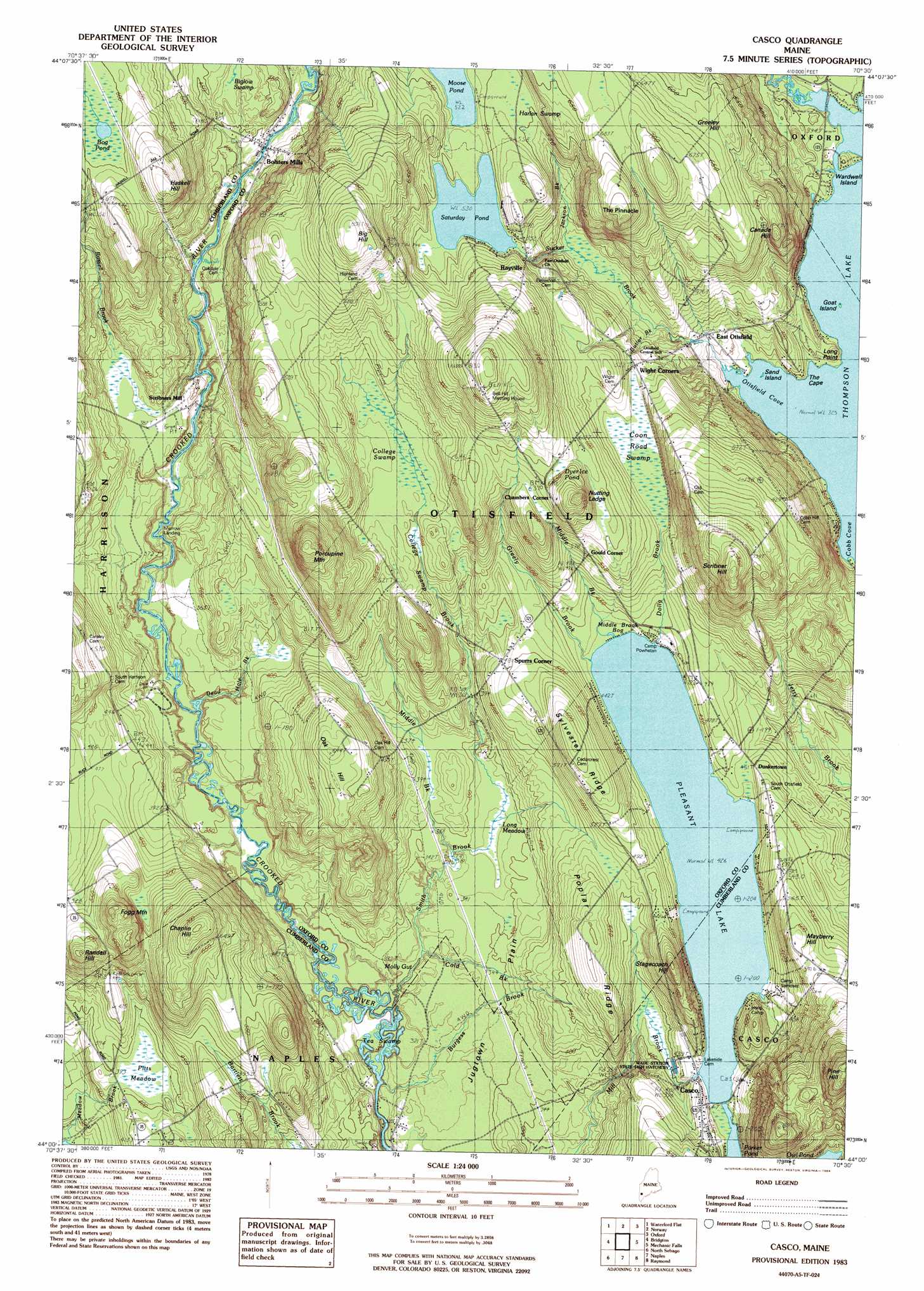
Casco Topo Map Maine
To zoom in, hover over the map of Casco
USGS Topo Quad 44070a5 - 1:24,000 scale
| Topo Map Name: | Casco |
| USGS Topo Quad ID: | 44070a5 |
| Print Size: | ca. 21 1/4" wide x 27" high |
| Southeast Coordinates: | 44° N latitude / 70.5° W longitude |
| Map Center Coordinates: | 44.0625° N latitude / 70.5625° W longitude |
| U.S. State: | ME |
| Filename: | o44070a5.jpg |
| Download Map JPG Image: | Casco topo map 1:24,000 scale |
| Map Type: | Topographic |
| Topo Series: | 7.5´ |
| Map Scale: | 1:24,000 |
| Source of Map Images: | United States Geological Survey (USGS) |
| Alternate Map Versions: |
Casco ME 1983, updated 1984 Download PDF Buy paper map Casco ME 2011 Download PDF Buy paper map Casco ME 2014 Download PDF Buy paper map |
1:24,000 Topo Quads surrounding Casco
East Stoneham |
Greenwood |
West Paris |
West Sumner |
Buckfield |
North Waterford |
Ralph |
Norway |
Oxford |
Lake Auburn West |
Pleasant Mountain |
Bridgton |
Casco |
Mechanic Falls |
Minot |
Hiram |
North Sebago |
Naples |
Raymond |
Gray |
Cornish |
Steep Falls |
Sebago Lake |
North Windham |
Cumberland Center |
> Back to 44070a1 at 1:100,000 scale
> Back to 44070a1 at 1:250,000 scale
> Back to U.S. Topo Maps home
Casco topo map: Gazetteer
Casco: Bays
Otisfield Cove elevation 99m 324′Casco: Benches
Nutting Ledge elevation 186m 610′Casco: Capes
Long Point elevation 111m 364′The Cape elevation 106m 347′
Casco: Dams
Rayville Dam elevation 162m 531′Casco: Flats
Jugtown Plain elevation 105m 344′Casco: Guts
Molly Gut elevation 90m 295′Casco: Islands
Goat Island elevation 105m 344′Sand Island elevation 99m 324′
Wardwell Island elevation 105m 344′
Casco: Lakes
Bog Pond elevation 182m 597′Dyer Ice Pond elevation 194m 636′
Pleasant Lake elevation 130m 426′
Casco: Populated Places
Bolsters Mills elevation 120m 393′Casco elevation 141m 462′
Chambers Corner elevation 193m 633′
Cobb Cove elevation 106m 347′
Dunkertown elevation 138m 452′
East Otisfield elevation 118m 387′
Gould Corner elevation 174m 570′
Merrow Landing elevation 96m 314′
Rayville elevation 167m 547′
Scribners Mill elevation 109m 357′
Spurrs Corner elevation 147m 482′
Wight Corner elevation 157m 515′
Casco: Reservoirs
Saturday Pond elevation 162m 531′Casco: Ridges
Poplar Ridge elevation 167m 547′Sylvester Ridge elevation 188m 616′
Casco: Streams
Burgess Brook elevation 89m 291′Cold Brook elevation 93m 305′
College Swamp Brook elevation 104m 341′
Dead Hole Brook elevation 94m 308′
Dolly Brook elevation 130m 426′
Eastman Brook elevation 118m 387′
Greeley Brook elevation 99m 324′
Greely Brook elevation 130m 426′
Jackson Brook elevation 130m 426′
Knights Brook elevation 109m 357′
Middle Brook elevation 130m 426′
Russell Brook elevation 112m 367′
Smith Brook elevation 89m 291′
Sucker Brook elevation 99m 324′
Casco: Summits
Big Hill elevation 255m 836′Canada Hill elevation 205m 672′
Chaplin Hill elevation 226m 741′
Fogg Mountain elevation 218m 715′
Greeley Hill elevation 190m 623′
Mayberry Hill elevation 184m 603′
Pine Hill elevation 289m 948′
Porcupine Mountain elevation 261m 856′
Randall Hill elevation 194m 636′
Scribner Hill elevation 271m 889′
The Pinnacle elevation 231m 757′
Casco: Swamps
Biglow Swamp elevation 125m 410′College Swamp elevation 154m 505′
Coon Road Swamp elevation 157m 515′
Harlan Swamp elevation 169m 554′
Long Meadows elevation 101m 331′
Middle Brook Bog elevation 130m 426′
Pitts Meadow elevation 117m 383′
Ted Swamp elevation 89m 291′
Casco digital topo map on disk
Buy this Casco topo map showing relief, roads, GPS coordinates and other geographical features, as a high-resolution digital map file on DVD:
Maine, New Hampshire, Rhode Island & Eastern Massachusetts
Buy digital topo maps: Maine, New Hampshire, Rhode Island & Eastern Massachusetts