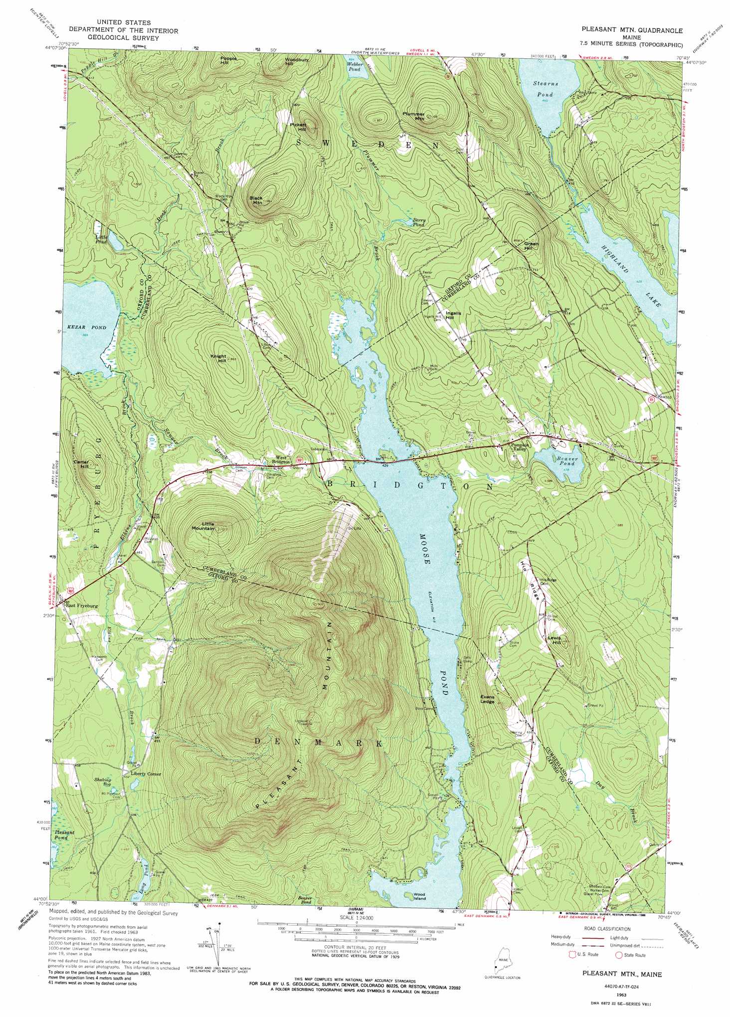
Pleasant Mountain Topo Map Maine
To zoom in, hover over the map of Pleasant Mountain
USGS Topo Quad 44070a7 - 1:24,000 scale
| Topo Map Name: | Pleasant Mountain |
| USGS Topo Quad ID: | 44070a7 |
| Print Size: | ca. 21 1/4" wide x 27" high |
| Southeast Coordinates: | 44° N latitude / 70.75° W longitude |
| Map Center Coordinates: | 44.0625° N latitude / 70.8125° W longitude |
| U.S. State: | ME |
| Filename: | o44070a7.jpg |
| Download Map JPG Image: | Pleasant Mountain topo map 1:24,000 scale |
| Map Type: | Topographic |
| Topo Series: | 7.5´ |
| Map Scale: | 1:24,000 |
| Source of Map Images: | United States Geological Survey (USGS) |
| Alternate Map Versions: |
Pleasant Mtn ME 1963, updated 1965 Download PDF Buy paper map Pleasant Mtn ME 1963, updated 1988 Download PDF Buy paper map Pleasant Mtn ME 1963, updated 1988 Download PDF Buy paper map Pleasant Mountain ME 2011 Download PDF Buy paper map Pleasant Mountain ME 2014 Download PDF Buy paper map |
1:24,000 Topo Quads surrounding Pleasant Mountain
Wild River |
Speckled Mountain |
East Stoneham |
Greenwood |
West Paris |
Chatham |
Center Lovell |
North Waterford |
Ralph |
Norway |
North Conway East |
Fryeburg |
Pleasant Mountain |
Bridgton |
Casco |
Conway |
Brownfield |
Hiram |
North Sebago |
Naples |
Freedom |
Kezar Falls |
Cornish |
Steep Falls |
Sebago Lake |
> Back to 44070a1 at 1:100,000 scale
> Back to 44070a1 at 1:250,000 scale
> Back to U.S. Topo Maps home
Pleasant Mountain topo map: Gazetteer
Pleasant Mountain: Islands
Wood Island elevation 128m 419′Pleasant Mountain: Lakes
Beaver Pond elevation 146m 479′Little Pond elevation 114m 374′
Stearns Pond elevation 134m 439′
Webber Pond elevation 202m 662′
Pleasant Mountain: Populated Places
East Fryeburg elevation 149m 488′Liberty Corner elevation 138m 452′
West Bridgton elevation 153m 501′
Pleasant Mountain: Reservoirs
Berry Pond elevation 144m 472′Pleasant Mountain: Ridges
Hio Ridge elevation 240m 787′Pleasant Mountain: Streams
Dock Brook elevation 113m 370′Elkins Brook elevation 112m 367′
Plummer Brook elevation 127m 416′
Sawyer Brook elevation 113m 370′
Pleasant Mountain: Summits
Black Mountain elevation 322m 1056′Carter Hill elevation 222m 728′
Evans Ledge elevation 264m 866′
Green Hill elevation 257m 843′
Ingalls Hill elevation 229m 751′
Knight Hill elevation 263m 862′
Lewis Hill elevation 281m 921′
Little Mountain elevation 314m 1030′
Pickett Hill elevation 328m 1076′
Pleasant Mountain elevation 611m 2004′
Plummer Mountain elevation 330m 1082′
Woodbury Hill elevation 348m 1141′
Pleasant Mountain: Swamps
Shaking Bog elevation 137m 449′Pleasant Mountain digital topo map on disk
Buy this Pleasant Mountain topo map showing relief, roads, GPS coordinates and other geographical features, as a high-resolution digital map file on DVD:
Maine, New Hampshire, Rhode Island & Eastern Massachusetts
Buy digital topo maps: Maine, New Hampshire, Rhode Island & Eastern Massachusetts