Monmouth Topo Map Maine
To zoom in, hover over the map of Monmouth
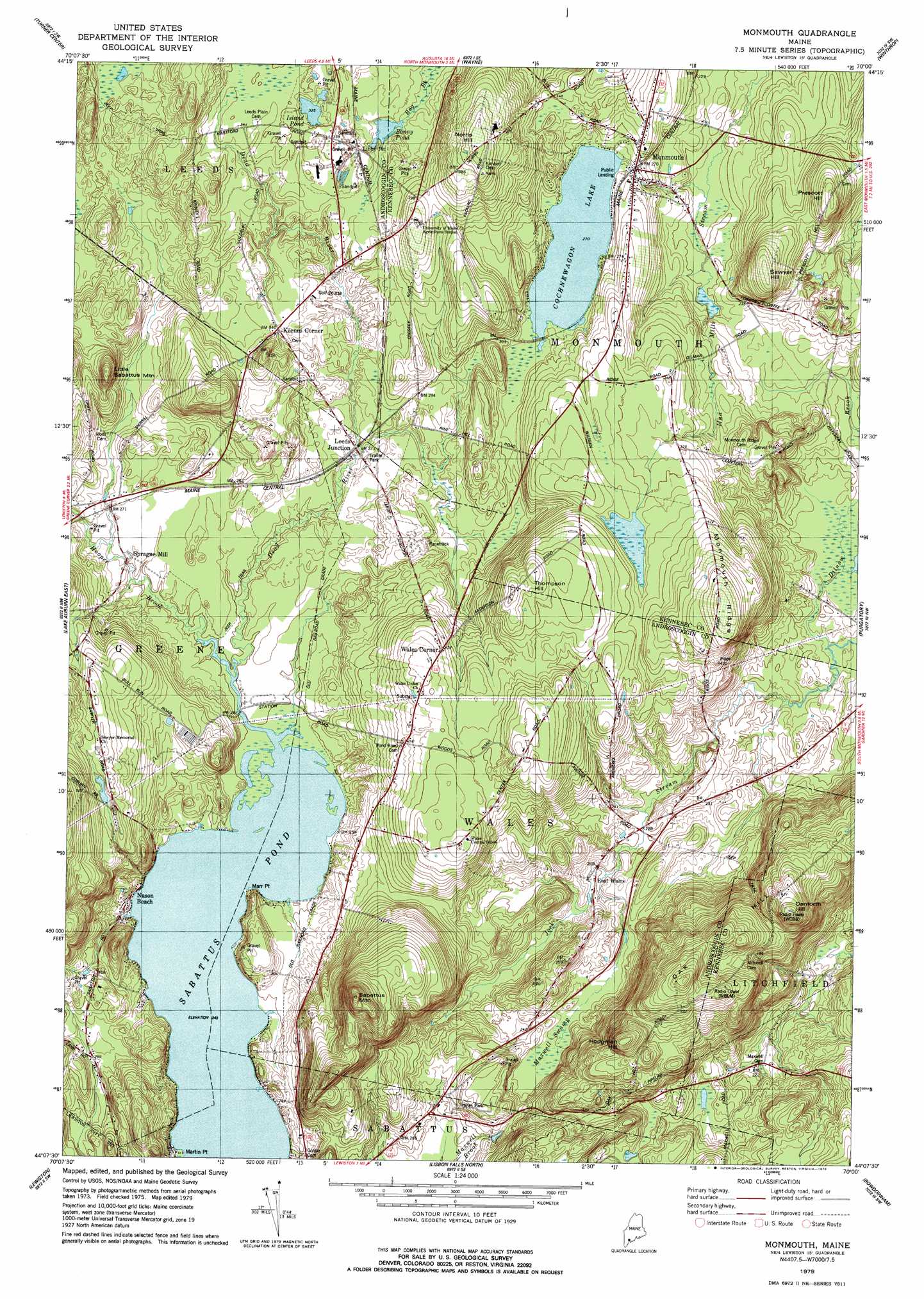
USGS Topo Quad 44070b1 - 1:24,000 scale
| Topo Map Name: | Monmouth |
| USGS Topo Quad ID: | 44070b1 |
| Print Size: | ca. 21 1/4" wide x 27" high |
| Southeast Coordinates: | 44.125° N latitude / 70° W longitude |
| Map Center Coordinates: | 44.1875° N latitude / 70.0625° W longitude |
| U.S. State: | ME |
| Filename: | o44070b1.jpg |
| Download Map JPG Image: | Monmouth topo map 1:24,000 scale |
| Map Type: | Topographic |
| Topo Series: | 7.5´ |
| Map Scale: | 1:24,000 |
| Source of Map Images: | United States Geological Survey (USGS) |
| Alternate Map Versions: |
Monmouth ME 1979, updated 1979 Download PDF Buy paper map Monmouth ME 2011 Download PDF Buy paper map Monmouth ME 2014 Download PDF Buy paper map |
1:24,000 Topo Quads surrounding Monmouth
Canton |
Livermore Falls |
Fayette |
Readfield |
Belgrade |
Buckfield |
Turner Center |
Wayne |
Winthrop |
Augusta |
Lake Auburn West |
Lake Auburn East |
Monmouth |
Purgatory |
Gardiner |
Minot |
Lewiston |
Lisbon Falls North |
Bowdoinham |
Richmond |
Gray |
North Pownal |
Lisbon Falls South |
Brunswick |
Bath |
> Back to 44070a1 at 1:100,000 scale
> Back to 44070a1 at 1:250,000 scale
> Back to U.S. Topo Maps home
Monmouth topo map: Gazetteer
Monmouth: Bridges
Thompson Bridge elevation 74m 242′Monmouth: Capes
Marr Point elevation 83m 272′Martin Point elevation 75m 246′
Monmouth: Dams
Cochnewagon Dam elevation 82m 269′Monmouth: Lakes
Bonny Pond elevation 94m 308′Cochnewagon Lake elevation 82m 269′
Custer Pond elevation 75m 246′
Island Pond elevation 99m 324′
Monmouth: Populated Places
East Wales elevation 61m 200′Keenes Corner elevation 101m 331′
Leeds Junction elevation 78m 255′
Monmouth elevation 83m 272′
Nason Beach elevation 84m 275′
Sprague Mill elevation 79m 259′
Wales Corner elevation 131m 429′
Monmouth: Ridges
Monmouth Ridge elevation 165m 541′Monmouth: Streams
Dead River elevation 74m 242′Hooper Brook elevation 74m 242′
Monmouth: Summits
Danforth Hill elevation 208m 682′Hodgman Hill elevation 198m 649′
Little Sabattus Mountain elevation 160m 524′
Norris Hill elevation 164m 538′
Oak Hill elevation 189m 620′
Prescott Hill elevation 129m 423′
Sabattus Mountain elevation 244m 800′
Sawyer Hill elevation 132m 433′
Thompson Hill elevation 149m 488′
Monmouth: Swamps
Maxwell Swamp elevation 70m 229′Monmouth digital topo map on disk
Buy this Monmouth topo map showing relief, roads, GPS coordinates and other geographical features, as a high-resolution digital map file on DVD:
Maine, New Hampshire, Rhode Island & Eastern Massachusetts
Buy digital topo maps: Maine, New Hampshire, Rhode Island & Eastern Massachusetts