Ralph Topo Map Maine
To zoom in, hover over the map of Ralph
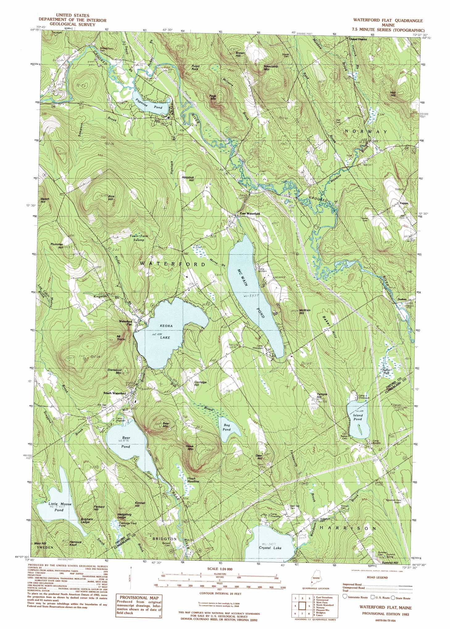
USGS Topo Quad 44070b6 - 1:24,000 scale
| Topo Map Name: | Ralph |
| USGS Topo Quad ID: | 44070b6 |
| Print Size: | ca. 21 1/4" wide x 27" high |
| Southeast Coordinates: | 44.125° N latitude / 70.625° W longitude |
| Map Center Coordinates: | 44.1875° N latitude / 70.6875° W longitude |
| U.S. State: | ME |
| Filename: | o44070b6.jpg |
| Download Map JPG Image: | Ralph topo map 1:24,000 scale |
| Map Type: | Topographic |
| Topo Series: | 7.5´ |
| Map Scale: | 1:24,000 |
| Source of Map Images: | United States Geological Survey (USGS) |
| Alternate Map Versions: |
Waterford Flat ME 1983, updated 1984 Download PDF Buy paper map Waterford Flat ME 2011 Download PDF Buy paper map Waterford Flat ME 2014 Download PDF Buy paper map |
1:24,000 Topo Quads surrounding Ralph
Gilead |
Bethel |
Bryant Pond |
Mount Zircon |
Worthley Pond |
Speckled Mountain |
East Stoneham |
Greenwood |
West Paris |
West Sumner |
Center Lovell |
North Waterford |
Ralph |
Norway |
Oxford |
Fryeburg |
Pleasant Mountain |
Bridgton |
Casco |
Mechanic Falls |
Brownfield |
Hiram |
North Sebago |
Naples |
Raymond |
> Back to 44070a1 at 1:100,000 scale
> Back to 44070a1 at 1:250,000 scale
> Back to U.S. Topo Maps home
Ralph topo map: Gazetteer
Ralph: Airports
Mountain View Airport elevation 178m 583′Ralph: Cliffs
Brigham Ledge elevation 181m 593′Hedgehog Ledge elevation 177m 580′
Ralph: Dams
Bear Pond Dam elevation 113m 370′Ralph: Lakes
Bog Pond elevation 204m 669′Cabbage Yard Pond elevation 143m 469′
Island Pond elevation 136m 446′
Keoka Lake elevation 150m 492′
Little Loose Pond elevation 166m 544′
McWain Pond elevation 164m 538′
Papoose Pond elevation 149m 488′
Ralph: Populated Places
East Waterford elevation 165m 541′Sodom elevation 154m 505′
South Waterford elevation 147m 482′
Waterford Flat elevation 158m 518′
Yagger elevation 197m 646′
Ralph: Reservoirs
Bear Pond elevation 113m 370′Ralph: Streams
Farnsworth Brook elevation 112m 367′Hemlock Brook elevation 146m 479′
Herrick Brook elevation 184m 603′
Hobbs Brook elevation 146m 479′
Kedar Brook elevation 152m 498′
Kingman Brook elevation 176m 577′
McIntire Brook elevation 144m 472′
Meadow Brook elevation 146m 479′
Mill Brook elevation 115m 377′
Mills Brook elevation 144m 472′
Morse Brook elevation 164m 538′
Mutiny Brook elevation 118m 387′
Scoggins Brook elevation 121m 396′
Swell Brook elevation 149m 488′
Woodsum Brook elevation 94m 308′
Ralph: Summits
Baker Hill elevation 213m 698′Bear Mountain elevation 325m 1066′
Brown Hill elevation 359m 1177′
Coolidge Hill elevation 221m 725′
Deer Hill elevation 254m 833′
Hawk Mountain elevation 319m 1046′
Hemlock Hill elevation 226m 741′
Hemlock Knoll elevation 246m 807′
Holt Hill elevation 220m 721′
Kimball Hill elevation 229m 751′
McWain Hill elevation 243m 797′
Mount Tire'm elevation 332m 1089′
Newcomb Mountain elevation 351m 1151′
Packard Hill elevation 233m 764′
Page Mountain elevation 231m 757′
Pulpit Rock elevation 240m 787′
Rice Hill elevation 398m 1305′
Stanwood Mountain elevation 248m 813′
Temple Hill elevation 227m 744′
Ralph: Swamps
Baker Bog elevation 132m 433′Mud Pond elevation 178m 583′
Town Farm Swamp elevation 235m 770′
Ralph digital topo map on disk
Buy this Ralph topo map showing relief, roads, GPS coordinates and other geographical features, as a high-resolution digital map file on DVD:
Maine, New Hampshire, Rhode Island & Eastern Massachusetts
Buy digital topo maps: Maine, New Hampshire, Rhode Island & Eastern Massachusetts