Wilton Topo Map Maine
To zoom in, hover over the map of Wilton
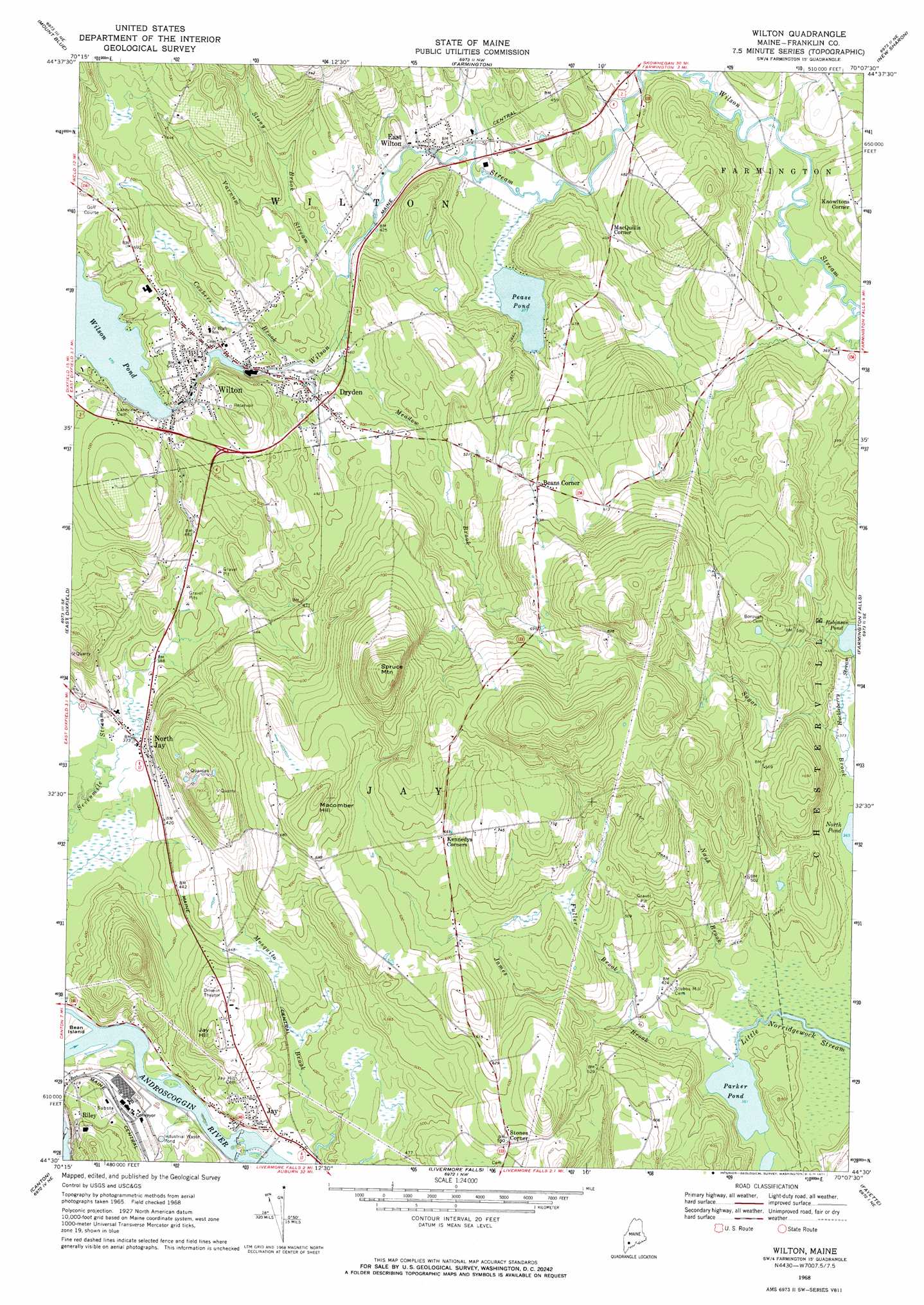
USGS Topo Quad 44070e2 - 1:24,000 scale
| Topo Map Name: | Wilton |
| USGS Topo Quad ID: | 44070e2 |
| Print Size: | ca. 21 1/4" wide x 27" high |
| Southeast Coordinates: | 44.5° N latitude / 70.125° W longitude |
| Map Center Coordinates: | 44.5625° N latitude / 70.1875° W longitude |
| U.S. State: | ME |
| Filename: | o44070e2.jpg |
| Download Map JPG Image: | Wilton topo map 1:24,000 scale |
| Map Type: | Topographic |
| Topo Series: | 7.5´ |
| Map Scale: | 1:24,000 |
| Source of Map Images: | United States Geological Survey (USGS) |
| Alternate Map Versions: |
Wilton ME 1968, updated 1971 Download PDF Buy paper map Wilton ME 2011 Download PDF Buy paper map Wilton ME 2014 Download PDF Buy paper map |
1:24,000 Topo Quads surrounding Wilton
Madrid |
Phillips |
Strong |
New Vineyard |
Madison West |
Weld |
Mount Blue |
Farmington |
New Sharon |
Mercer |
Dixfield |
East Dixfield |
Wilton |
Farmington Falls |
Belgrade Lakes |
Worthley Pond |
Canton |
Livermore Falls |
Fayette |
Readfield |
West Sumner |
Buckfield |
Turner Center |
Wayne |
Winthrop |
> Back to 44070e1 at 1:100,000 scale
> Back to 44070a1 at 1:250,000 scale
> Back to U.S. Topo Maps home
Wilton topo map: Gazetteer
Wilton: Airports
Hilltop Airport elevation 175m 574′Wilton: Dams
Jay Dam elevation 105m 344′Riley Dam elevation 107m 351′
Wilson Pond Dam elevation 176m 577′
Wilton: Islands
Bean Island elevation 110m 360′Wilton: Lakes
Parker Pond elevation 110m 360′Pease Pond elevation 114m 374′
Robinson Pond elevation 125m 410′
Wilton: Parks
Kineowatha Park elevation 189m 620′Wilton: Populated Places
Beans Corner elevation 187m 613′Dryden elevation 147m 482′
East Wilton elevation 123m 403′
Jay elevation 112m 367′
Knowltons Corner elevation 149m 488′
MacQuillis Corner elevation 124m 406′
North Jay elevation 115m 377′
Riley elevation 147m 482′
Stones Corner elevation 173m 567′
Wilton elevation 168m 551′
Wilton: Reservoirs
Androscoggin River Reservoir elevation 105m 344′Androscoggin River Reservoir elevation 107m 351′
Wilson Pond elevation 176m 577′
Wilton: Streams
Coubers Brook elevation 141m 462′Fuller Brook elevation 117m 383′
Huckleberry Stream elevation 113m 370′
James Brook elevation 110m 360′
Meadow Brook elevation 136m 446′
Nash Brook elevation 110m 360′
Stony Brook elevation 141m 462′
Varnum Stream elevation 132m 433′
Wilton: Summits
Jay Hill elevation 190m 623′Macomber Hill elevation 258m 846′
Spruce Mountain elevation 339m 1112′
Wilton digital topo map on disk
Buy this Wilton topo map showing relief, roads, GPS coordinates and other geographical features, as a high-resolution digital map file on DVD:
Maine, New Hampshire, Rhode Island & Eastern Massachusetts
Buy digital topo maps: Maine, New Hampshire, Rhode Island & Eastern Massachusetts