B Pond Topo Map Maine
To zoom in, hover over the map of B Pond
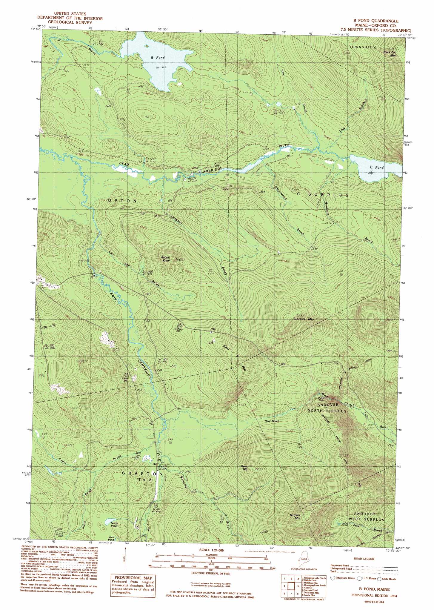
USGS Topo Quad 44070f8 - 1:24,000 scale
| Topo Map Name: | B Pond |
| USGS Topo Quad ID: | 44070f8 |
| Print Size: | ca. 21 1/4" wide x 27" high |
| Southeast Coordinates: | 44.625° N latitude / 70.875° W longitude |
| Map Center Coordinates: | 44.6875° N latitude / 70.9375° W longitude |
| U.S. State: | ME |
| Filename: | o44070f8.jpg |
| Download Map JPG Image: | B Pond topo map 1:24,000 scale |
| Map Type: | Topographic |
| Topo Series: | 7.5´ |
| Map Scale: | 1:24,000 |
| Source of Map Images: | United States Geological Survey (USGS) |
| Alternate Map Versions: |
B Pond ME 1977, updated 1983 Download PDF Buy paper map B Pond ME 1977, updated 1984 Download PDF Buy paper map B Pond ME 1984, updated 1985 Download PDF Buy paper map B Pond ME 2011 Download PDF Buy paper map B Pond ME 2014 Download PDF Buy paper map |
1:24,000 Topo Quads surrounding B Pond
Mount Pisgah |
Wilsons Mills |
Richardson Pond |
Oquossoc |
Rangeley |
Errol |
Umbagog Lake North |
Middle Dam |
Metallak Mountain |
Houghton |
Teakettle Ridge |
Umbagog Lake South |
B Pond |
Andover |
Ellis Pond |
Milan |
Success Pond |
Old Speck Mountain |
Puzzle Mountain |
East Andover |
Berlin |
Shelburne |
Gilead |
Bethel |
Bryant Pond |
> Back to 44070e1 at 1:100,000 scale
> Back to 44070a1 at 1:250,000 scale
> Back to U.S. Topo Maps home
B Pond topo map: Gazetteer
B Pond: Falls
Dunn Falls elevation 399m 1309′B Pond: Gaps
Dunn Notch elevation 443m 1453′B Pond: Lakes
B Pond elevation 423m 1387′C Pond elevation 393m 1289′
North Pond elevation 478m 1568′
B Pond: Streams
Black Brook elevation 447m 1466′Campbell Brook elevation 390m 1279′
Cedar Brook elevation 437m 1433′
Greenwood Brook elevation 393m 1289′
Lost Brook elevation 395m 1295′
Lou Ann Brook elevation 397m 1302′
Mountain Brook elevation 392m 1286′
Red Brook elevation 393m 1289′
Swift Cambridge River elevation 388m 1272′
Whitecap Brook elevation 440m 1443′
B Pond: Summits
Black Cat Mountain elevation 771m 2529′Deer Hill elevation 680m 2230′
East B Hill elevation 664m 2178′
Rabbit Knoll elevation 619m 2030′
Spruce Mountain elevation 715m 2345′
Surplus Mountain elevation 896m 2939′
B Pond digital topo map on disk
Buy this B Pond topo map showing relief, roads, GPS coordinates and other geographical features, as a high-resolution digital map file on DVD:
Maine, New Hampshire, Rhode Island & Eastern Massachusetts
Buy digital topo maps: Maine, New Hampshire, Rhode Island & Eastern Massachusetts