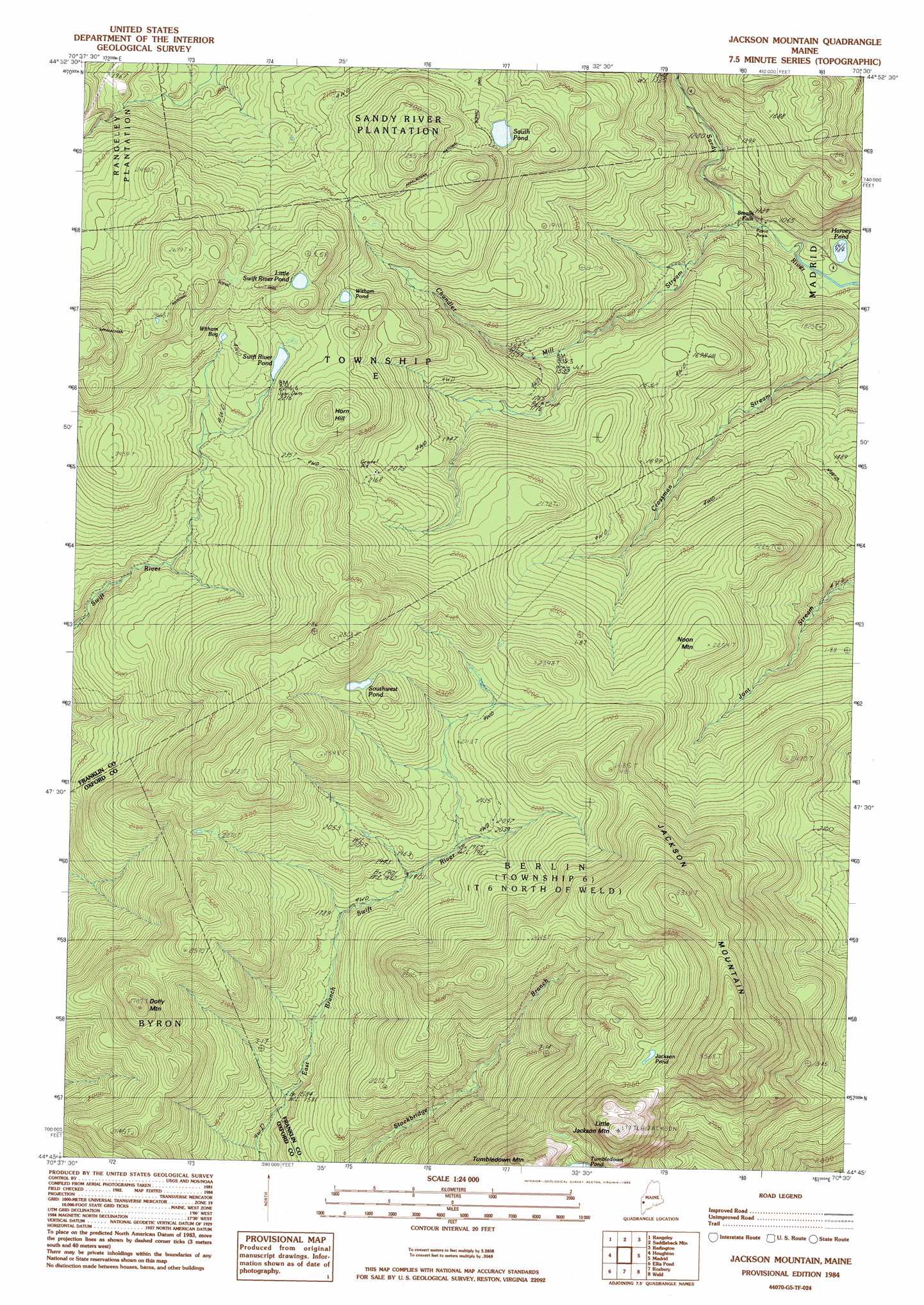
Jackson Mountain Topo Map Maine
To zoom in, hover over the map of Jackson Mountain
USGS Topo Quad 44070g5 - 1:24,000 scale
| Topo Map Name: | Jackson Mountain |
| USGS Topo Quad ID: | 44070g5 |
| Print Size: | ca. 21 1/4" wide x 27" high |
| Southeast Coordinates: | 44.75° N latitude / 70.5° W longitude |
| Map Center Coordinates: | 44.8125° N latitude / 70.5625° W longitude |
| U.S. State: | ME |
| Filename: | o44070g5.jpg |
| Download Map JPG Image: | Jackson Mountain topo map 1:24,000 scale |
| Map Type: | Topographic |
| Topo Series: | 7.5´ |
| Map Scale: | 1:24,000 |
| Source of Map Images: | United States Geological Survey (USGS) |
| Alternate Map Versions: |
Jackson Mountain ME 1977, updated 1983 Download PDF Buy paper map Jackson Mountain ME 1984, updated 1985 Download PDF Buy paper map Jackson Mountain ME 2011 Download PDF Buy paper map Jackson Mountain ME 2014 Download PDF Buy paper map |
1:24,000 Topo Quads surrounding Jackson Mountain
Kennebago |
Kennebago Lake |
Quill Hill |
Black Nubble |
Sugarloaf Mountain |
Oquossoc |
Rangeley |
Saddleback Mountain |
Redington |
Mount Abraham |
Metallak Mountain |
Houghton |
Jackson Mountain |
Madrid |
Phillips |
Andover |
Ellis Pond |
Roxbury |
Weld |
Mount Blue |
Puzzle Mountain |
East Andover |
Rumford |
Dixfield |
East Dixfield |
> Back to 44070e1 at 1:100,000 scale
> Back to 44070a1 at 1:250,000 scale
> Back to U.S. Topo Maps home
Jackson Mountain topo map: Gazetteer
Jackson Mountain: Falls
Smalls Falls elevation 340m 1115′Jackson Mountain: Lakes
Harvey Pond elevation 300m 984′Jackson Pond elevation 901m 2956′
Little Swift River Pond elevation 735m 2411′
South Pond elevation 669m 2194′
Southwest Pond elevation 736m 2414′
Swift River Pond elevation 682m 2237′
Witham Bog elevation 700m 2296′
Witham Pond elevation 679m 2227′
Jackson Mountain: Ranges
Blue Mountains elevation 742m 2434′Jackson Mountain: Streams
Chandler Mill Stream elevation 318m 1043′Jackson Mountain: Summits
Dolly Mountain elevation 786m 2578′Horn Hill elevation 758m 2486′
Jackson Mountain elevation 1044m 3425′
Little Jackson Mountain elevation 1049m 3441′
Noon Mountain elevation 664m 2178′
Tumbledown Mountain elevation 918m 3011′
Jackson Mountain digital topo map on disk
Buy this Jackson Mountain topo map showing relief, roads, GPS coordinates and other geographical features, as a high-resolution digital map file on DVD:
Maine, New Hampshire, Rhode Island & Eastern Massachusetts
Buy digital topo maps: Maine, New Hampshire, Rhode Island & Eastern Massachusetts