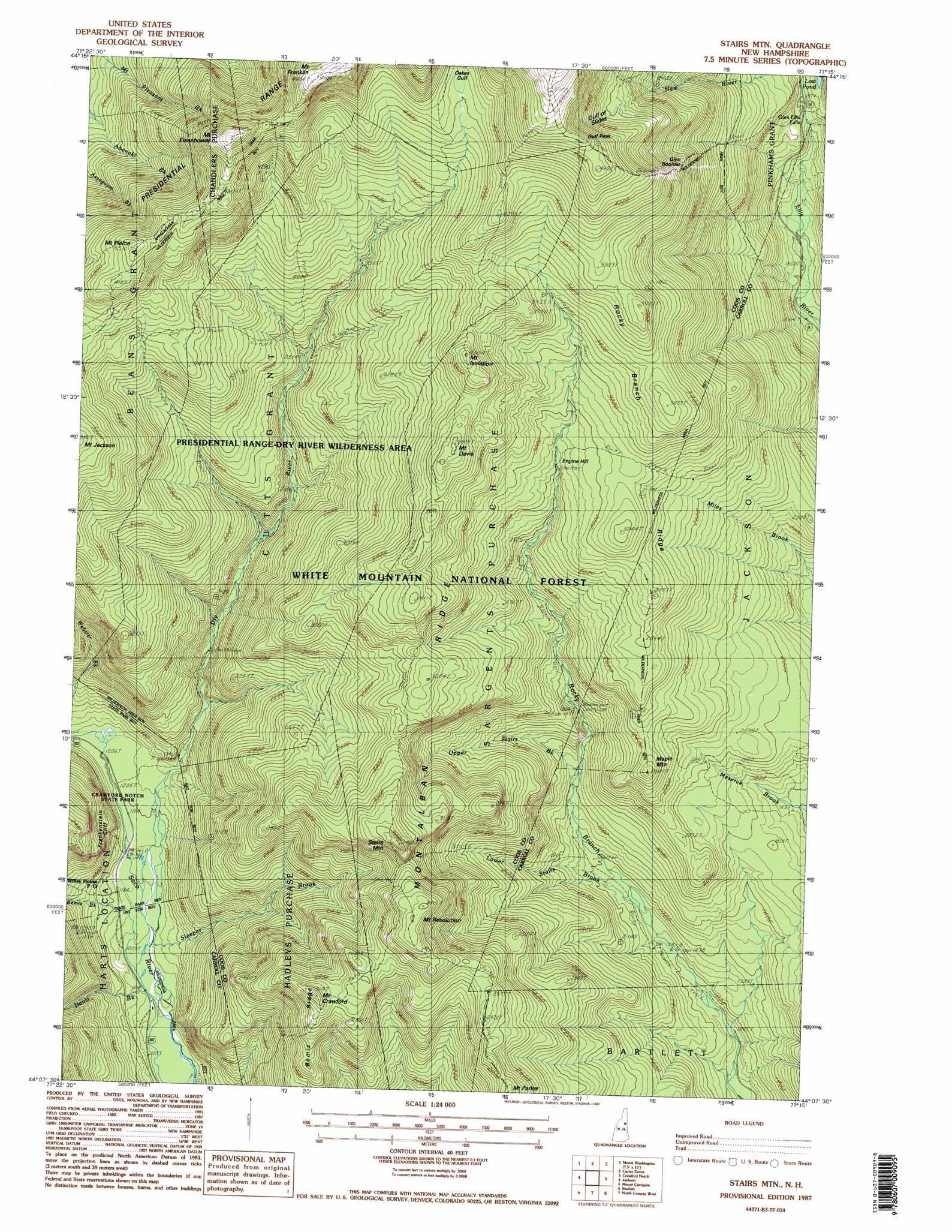
Stairs Mountain Topo Map New Hampshire
To zoom in, hover over the map of Stairs Mountain
USGS Topo Quad 44071b3 - 1:24,000 scale
| Topo Map Name: | Stairs Mountain |
| USGS Topo Quad ID: | 44071b3 |
| Print Size: | ca. 21 1/4" wide x 27" high |
| Southeast Coordinates: | 44.125° N latitude / 71.25° W longitude |
| Map Center Coordinates: | 44.1875° N latitude / 71.3125° W longitude |
| U.S. State: | NH |
| Filename: | o44071b3.jpg |
| Download Map JPG Image: | Stairs Mountain topo map 1:24,000 scale |
| Map Type: | Topographic |
| Topo Series: | 7.5´ |
| Map Scale: | 1:24,000 |
| Source of Map Images: | United States Geological Survey (USGS) |
| Alternate Map Versions: |
Stairs Mountain NH 1987, updated 1987 Download PDF Buy paper map Stairs Mountain NH 1987, updated 1987 Download PDF Buy paper map Stairs Mountain NH 1995, updated 2000 Download PDF Buy paper map Stairs Mountain NH 2012 Download PDF Buy paper map Stairs Mountain NH 2015 Download PDF Buy paper map |
| FStopo: | US Forest Service topo Stairs Mountain is available: Download FStopo PDF Download FStopo TIF |
1:24,000 Topo Quads surrounding Stairs Mountain
Lancaster |
Mount Crescent |
Berlin |
Shelburne |
|
Twin Mountain |
Mount Washington |
Carter Dome |
Wild River |
|
South Twin Mountain |
Crawford Notch |
Stairs Mountain |
Jackson |
Chatham |
Mount Osceola |
Mount Carrigan |
Bartlett |
North Conway West |
North Conway East |
Waterville Valley |
Mount Tripyramid |
Mount Chocorua |
Silver Lake |
Conway |
> Back to 44071a1 at 1:100,000 scale
> Back to 44070a1 at 1:250,000 scale
> Back to U.S. Topo Maps home
Stairs Mountain topo map: Gazetteer
Stairs Mountain: Cliffs
Frankenstein Cliff elevation 430m 1410′Stairs Mountain: Falls
Glen Ellis Falls elevation 559m 1833′Stairs Mountain: Lakes
Desolation Pond elevation 1157m 3795′Lost Pond elevation 620m 2034′
Stairs Mountain: Pillars
Glen Boulder elevation 1170m 3838′Stairs Mountain: Post Offices
Willey House Post Office elevation 387m 1269′Stairs Mountain: Ridges
Branch Ridge elevation 986m 3234′Montalban Ridge elevation 1306m 4284′
Presidential Range elevation 1385m 4543′
Rocky Branch Ridge elevation 1102m 3615′
Stairs Mountain: Slopes
Giant Stairs elevation 935m 3067′Stairs Mountain: Streams
Bemis Brook elevation 323m 1059′Davis Brook elevation 320m 1049′
Dry River elevation 322m 1056′
Lower Stairs Brook elevation 391m 1282′
Otis Brook elevation 330m 1082′
Sleeper Brook elevation 326m 1069′
Upper Stairs Brook elevation 485m 1591′
Stairs Mountain: Summits
Engine Hill elevation 942m 3090′Gulf Peak elevation 1455m 4773′
Maple Mountain elevation 793m 2601′
Mount Crawford elevation 938m 3077′
Mount Davis elevation 1161m 3809′
Mount Eisenhower elevation 1449m 4753′
Mount Franklin elevation 1516m 4973′
Mount Isolation elevation 1220m 4002′
Mount Jackson elevation 1211m 3973′
Mount Pierce elevation 1308m 4291′
Mount Resolution elevation 1036m 3398′
Stairs Mountain elevation 1053m 3454′
Stairs Mountain: Trails
Crawford Path elevation 1403m 4603′Davis Path elevation 1063m 3487′
Dry River Trail elevation 648m 2125′
Edmands Path elevation 1118m 3667′
Glen Boulder Trail elevation 1535m 5036′
Isolation Trail elevation 977m 3205′
Miles Brook Trail elevation 527m 1729′
Mount Clinton Trail elevation 834m 2736′
Mount Eisenhower Trail elevation 1102m 3615′
Mount Parker Trail elevation 883m 2896′
Mount Pleasant Trail elevation 1001m 3284′
Oakes Gulf Trail elevation 1208m 3963′
Rocky Branch Trail elevation 847m 2778′
Stairs Brook Trail elevation 828m 2716′
Stairs Col Trail elevation 485m 1591′
Stairs Mountain: Valleys
Crawford Notch elevation 370m 1213′Gulf of Slides elevation 1168m 3832′
Oakes Gulf elevation 1210m 3969′
Stairs Mountain digital topo map on disk
Buy this Stairs Mountain topo map showing relief, roads, GPS coordinates and other geographical features, as a high-resolution digital map file on DVD:
Maine, New Hampshire, Rhode Island & Eastern Massachusetts
Buy digital topo maps: Maine, New Hampshire, Rhode Island & Eastern Massachusetts