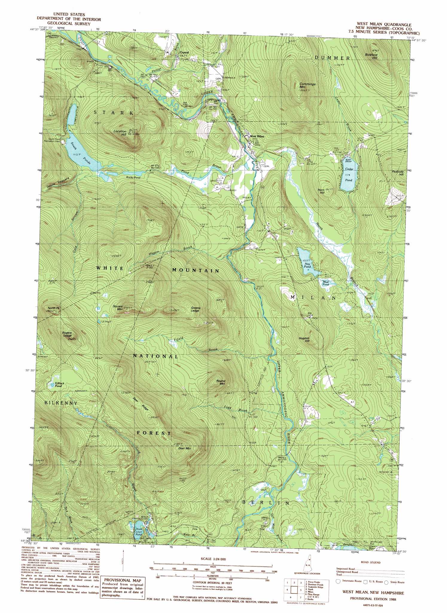
West Milan Topo Map New Hampshire
To zoom in, hover over the map of West Milan
USGS Topo Quad 44071e3 - 1:24,000 scale
| Topo Map Name: | West Milan |
| USGS Topo Quad ID: | 44071e3 |
| Print Size: | ca. 21 1/4" wide x 27" high |
| Southeast Coordinates: | 44.5° N latitude / 71.25° W longitude |
| Map Center Coordinates: | 44.5625° N latitude / 71.3125° W longitude |
| U.S. State: | NH |
| Filename: | o44071e3.jpg |
| Download Map JPG Image: | West Milan topo map 1:24,000 scale |
| Map Type: | Topographic |
| Topo Series: | 7.5´ |
| Map Scale: | 1:24,000 |
| Source of Map Images: | United States Geological Survey (USGS) |
| Alternate Map Versions: |
West Milan NH 1988, updated 1988 Download PDF Buy paper map West Milan NH 1995, updated 2000 Download PDF Buy paper map West Milan NH 2012 Download PDF Buy paper map West Milan NH 2015 Download PDF Buy paper map |
| FStopo: | US Forest Service topo West Milan is available: Download FStopo PDF Download FStopo TIF |
1:24,000 Topo Quads surrounding West Milan
Tinkerville |
Blue Mountain |
Dixville Notch |
Errol |
Umbagog Lake North |
Stratford |
Percy Peaks |
Dummer Ponds |
Teakettle Ridge |
Umbagog Lake South |
Groveton |
Stark |
West Milan |
Milan |
Success Pond |
Lancaster |
Mount Crescent |
Berlin |
Shelburne |
|
Twin Mountain |
Mount Washington |
Carter Dome |
Wild River |
> Back to 44071e1 at 1:100,000 scale
> Back to 44070a1 at 1:250,000 scale
> Back to U.S. Topo Maps home
West Milan topo map: Gazetteer
West Milan: Benches
Greens Ledge elevation 711m 2332′West Milan: Dams
York Pond Dam elevation 465m 1525′West Milan: Lakes
Cedar Pond elevation 339m 1112′Kilback Pond elevation 760m 2493′
Mud Pond elevation 316m 1036′
Nay Pond elevation 321m 1053′
Rocky Pond elevation 337m 1105′
South Ponds elevation 339m 1112′
West Milan: Populated Places
Crystal elevation 315m 1033′West Milan elevation 305m 1000′
West Milan: Reservoirs
York Pond elevation 455m 1492′West Milan: Ridges
Deer Ridge elevation 833m 2732′West Milan: Streams
Betty Brook elevation 364m 1194′Cedar Brook elevation 304m 997′
Cold Brook elevation 630m 2066′
Cold Stream elevation 341m 1118′
Devils Hopyard Stream elevation 346m 1135′
Fifield Brook elevation 333m 1092′
Fogg Brook elevation 340m 1115′
Higgins Brook elevation 314m 1030′
North Branch Upper Ammonoosuc River elevation 299m 980′
One Mile Brook elevation 362m 1187′
Phillips Brook elevation 298m 977′
Pond Brook elevation 299m 980′
West Milan: Summits
Bickford Hill elevation 574m 1883′Chandler Ledge elevation 448m 1469′
Cummings Mountain elevation 621m 2037′
Deer Mountain elevation 849m 2785′
Hodgdon Hill elevation 469m 1538′
Horn Hill elevation 416m 1364′
Location Hill elevation 606m 1988′
North Peak elevation 854m 2801′
Rogers Ledge elevation 904m 2965′
Round Mountain elevation 648m 2125′
Square Mountain elevation 817m 2680′
West Milan digital topo map on disk
Buy this West Milan topo map showing relief, roads, GPS coordinates and other geographical features, as a high-resolution digital map file on DVD:
Maine, New Hampshire, Rhode Island & Eastern Massachusetts
Buy digital topo maps: Maine, New Hampshire, Rhode Island & Eastern Massachusetts