Stark Topo Map New Hampshire
To zoom in, hover over the map of Stark
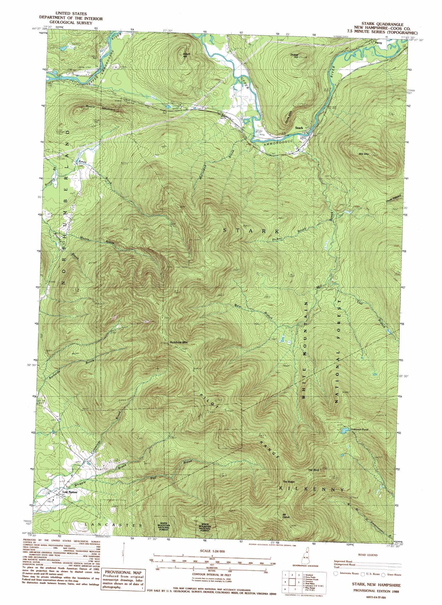
USGS Topo Quad 44071e4 - 1:24,000 scale
| Topo Map Name: | Stark |
| USGS Topo Quad ID: | 44071e4 |
| Print Size: | ca. 21 1/4" wide x 27" high |
| Southeast Coordinates: | 44.5° N latitude / 71.375° W longitude |
| Map Center Coordinates: | 44.5625° N latitude / 71.4375° W longitude |
| U.S. State: | NH |
| Filename: | o44071e4.jpg |
| Download Map JPG Image: | Stark topo map 1:24,000 scale |
| Map Type: | Topographic |
| Topo Series: | 7.5´ |
| Map Scale: | 1:24,000 |
| Source of Map Images: | United States Geological Survey (USGS) |
| Alternate Map Versions: |
Stark NH 1988, updated 1988 Download PDF Buy paper map Stark NH 1988, updated 1988 Download PDF Buy paper map Stark NH 1995, updated 2000 Download PDF Buy paper map Stark NH 2012 Download PDF Buy paper map Stark NH 2015 Download PDF Buy paper map |
| FStopo: | US Forest Service topo Stark is available: Download FStopo PDF Download FStopo TIF |
1:24,000 Topo Quads surrounding Stark
Bloomfield |
Tinkerville |
Blue Mountain |
Dixville Notch |
Errol |
Maidstone Lake |
Stratford |
Percy Peaks |
Dummer Ponds |
Teakettle Ridge |
Stone Mountain |
Groveton |
Stark |
West Milan |
Milan |
Lancaster |
Mount Crescent |
Berlin |
||
Twin Mountain |
Mount Washington |
Carter Dome |
> Back to 44071e1 at 1:100,000 scale
> Back to 44070a1 at 1:250,000 scale
> Back to U.S. Topo Maps home
Stark topo map: Gazetteer
Stark: Bridges
Stark Bridge elevation 290m 951′Stark: Lakes
Unknown Pond elevation 967m 3172′Stark: Populated Places
Lost Nation elevation 328m 1076′Percy elevation 307m 1007′
Stark elevation 288m 944′
Stark: Ridges
Pilot Range elevation 1046m 3431′Stark: Slopes
Devils Slide elevation 483m 1584′Stark: Streams
Ames Brook elevation 312m 1023′Cummings Brook elevation 323m 1059′
East Branch Mill Brook elevation 474m 1555′
Fox Brook elevation 354m 1161′
Hickey Brook elevation 429m 1407′
McCordick Brook elevation 773m 2536′
Mill Brook elevation 288m 944′
Rowells Brook elevation 296m 971′
West Branch Mill Brook elevation 540m 1771′
Stark: Summits
Beach Hill elevation 488m 1601′Dickey Hill elevation 482m 1581′
Hutchins Mountain elevation 1122m 3681′
Mill Mountain elevation 762m 2500′
Moore Mountain elevation 457m 1499′
Mount Cabot elevation 1258m 4127′
The Bulge elevation 1197m 3927′
The Horn elevation 1168m 3832′
Stark: Swamps
Mile Swamp elevation 277m 908′Stark digital topo map on disk
Buy this Stark topo map showing relief, roads, GPS coordinates and other geographical features, as a high-resolution digital map file on DVD:
Maine, New Hampshire, Rhode Island & Eastern Massachusetts
Buy digital topo maps: Maine, New Hampshire, Rhode Island & Eastern Massachusetts