Errol Topo Map New Hampshire
To zoom in, hover over the map of Errol
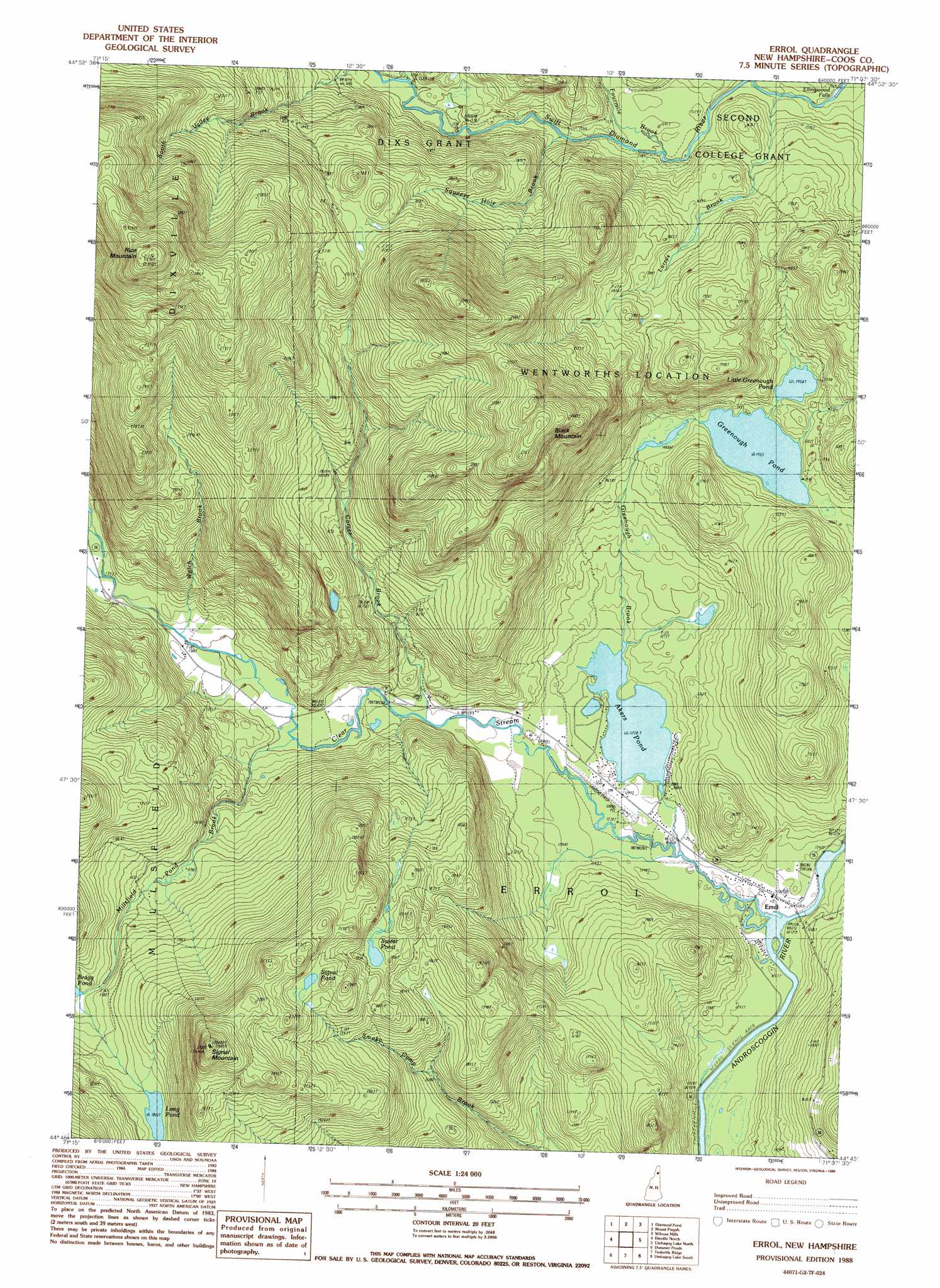
USGS Topo Quad 44071g2 - 1:24,000 scale
| Topo Map Name: | Errol |
| USGS Topo Quad ID: | 44071g2 |
| Print Size: | ca. 21 1/4" wide x 27" high |
| Southeast Coordinates: | 44.75° N latitude / 71.125° W longitude |
| Map Center Coordinates: | 44.8125° N latitude / 71.1875° W longitude |
| U.S. State: | NH |
| Filename: | o44071g2.jpg |
| Download Map JPG Image: | Errol topo map 1:24,000 scale |
| Map Type: | Topographic |
| Topo Series: | 7.5´ |
| Map Scale: | 1:24,000 |
| Source of Map Images: | United States Geological Survey (USGS) |
| Alternate Map Versions: |
Errol NH 1988, updated 1988 Download PDF Buy paper map Errol NH 1995, updated 1995 Download PDF Buy paper map Errol NH 1995, updated 1999 Download PDF Buy paper map Errol NH 2012 Download PDF Buy paper map Errol NH 2015 Download PDF Buy paper map |
1:24,000 Topo Quads surrounding Errol
Pittsburg |
Lake Francis |
Magalloway Mountain |
Bosebuck Mountain |
Lincoln Pond |
Lovering Mountain |
Diamond Pond |
Mount Pisgah |
Wilsons Mills |
Richardson Pond |
Blue Mountain |
Dixville Notch |
Errol |
Umbagog Lake North |
Middle Dam |
Percy Peaks |
Dummer Ponds |
Teakettle Ridge |
Umbagog Lake South |
B Pond |
Stark |
West Milan |
Milan |
Success Pond |
Old Speck Mountain |
> Back to 44071e1 at 1:100,000 scale
> Back to 44070a1 at 1:250,000 scale
> Back to U.S. Topo Maps home
Errol topo map: Gazetteer
Errol: Airports
Errol Airport elevation 379m 1243′Errol Airport elevation 379m 1243′
Errol: Dams
Akers Pond Dam elevation 415m 1361′Dixie Dam elevation 482m 1581′
Errol Dam elevation 383m 1256′
Errol: Falls
Ellingwood Falls elevation 434m 1423′Errol: Lakes
Greenough Pond elevation 437m 1433′Little Greenough Pond elevation 468m 1535′
Long Pond elevation 555m 1820′
Signal Pond elevation 657m 2155′
Sweat Pond elevation 595m 1952′
Errol: Populated Places
Errol elevation 374m 1227′Errol: Reservoirs
Akers Pond elevation 415m 1361′Errol: Streams
Clear Stream elevation 371m 1217′Corser Brook elevation 388m 1272′
East Branch Swift Diamond River elevation 456m 1496′
Greenough Brook elevation 372m 1220′
Larrys Brook elevation 448m 1469′
Millsfield Pond Brook elevation 391m 1282′
Squeeze Hole Brook elevation 474m 1555′
Welch Brook elevation 398m 1305′
West Branch Clear Stream elevation 413m 1354′
Errol: Summits
Black Mountain elevation 836m 2742′Rice Mountain elevation 1030m 3379′
Signal Mountain elevation 822m 2696′
Errol digital topo map on disk
Buy this Errol topo map showing relief, roads, GPS coordinates and other geographical features, as a high-resolution digital map file on DVD:
Maine, New Hampshire, Rhode Island & Eastern Massachusetts
Buy digital topo maps: Maine, New Hampshire, Rhode Island & Eastern Massachusetts