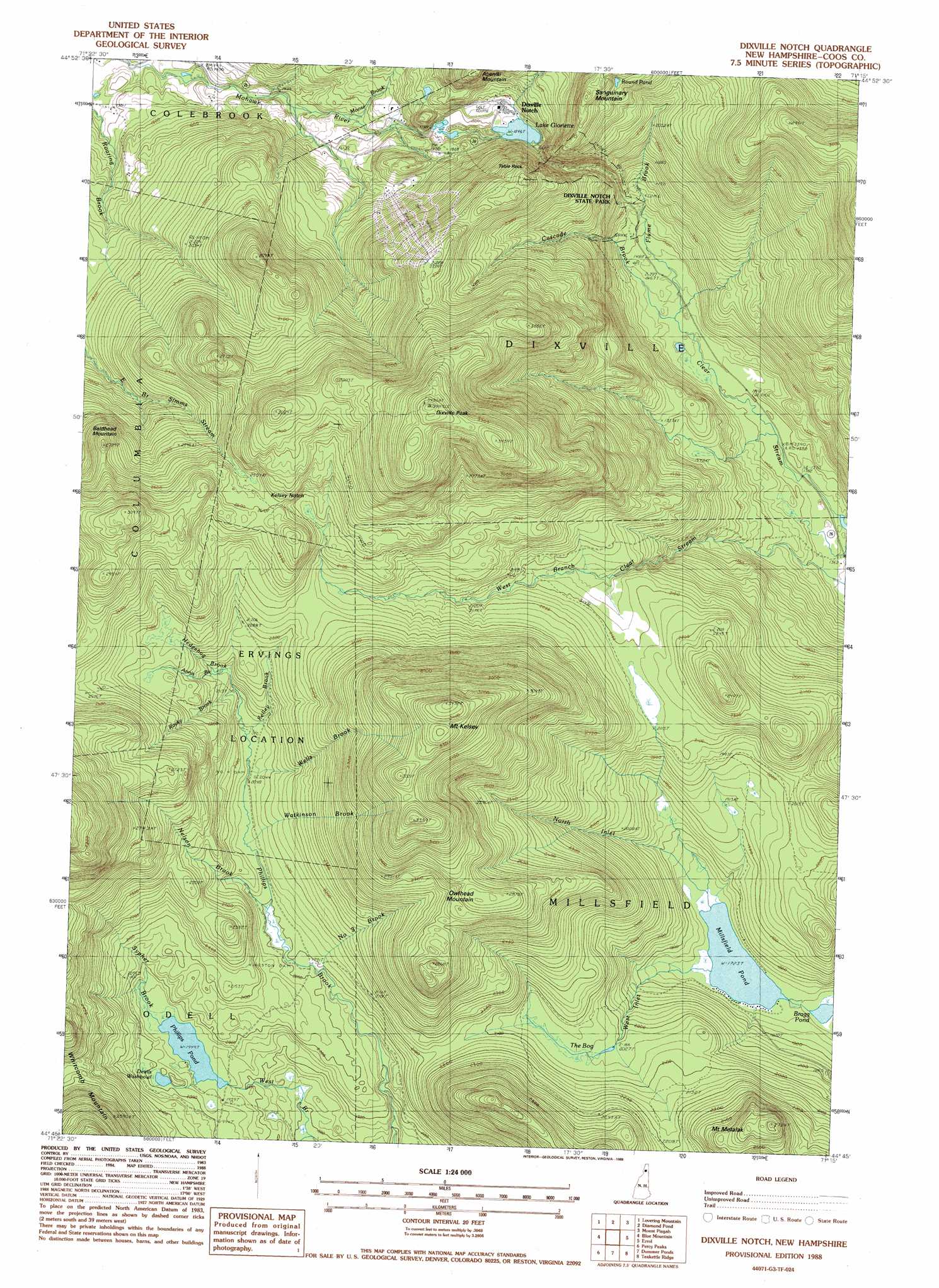
Dixville Notch Topo Map New Hampshire
To zoom in, hover over the map of Dixville Notch
USGS Topo Quad 44071g3 - 1:24,000 scale
| Topo Map Name: | Dixville Notch |
| USGS Topo Quad ID: | 44071g3 |
| Print Size: | ca. 21 1/4" wide x 27" high |
| Southeast Coordinates: | 44.75° N latitude / 71.25° W longitude |
| Map Center Coordinates: | 44.8125° N latitude / 71.3125° W longitude |
| U.S. State: | NH |
| Filename: | o44071g3.jpg |
| Download Map JPG Image: | Dixville Notch topo map 1:24,000 scale |
| Map Type: | Topographic |
| Topo Series: | 7.5´ |
| Map Scale: | 1:24,000 |
| Source of Map Images: | United States Geological Survey (USGS) |
| Alternate Map Versions: |
Dixville Notch NH 1988, updated 1988 Download PDF Buy paper map Dixville Notch NH 1988, updated 1988 Download PDF Buy paper map Dixville Notch NH 1996, updated 2000 Download PDF Buy paper map Dixville Notch NH 2012 Download PDF Buy paper map Dixville Notch NH 2015 Download PDF Buy paper map |
| FStopo: | US Forest Service topo Dixville Notch is available: Download FStopo PDF Download FStopo TIF |
1:24,000 Topo Quads surrounding Dixville Notch
Pittsburg |
Lake Francis |
Magalloway Mountain |
Bosebuck Mountain |
|
Monadnock Mountain |
Lovering Mountain |
Diamond Pond |
Mount Pisgah |
Wilsons Mills |
Tinkerville |
Blue Mountain |
Dixville Notch |
Errol |
Umbagog Lake North |
Stratford |
Percy Peaks |
Dummer Ponds |
Teakettle Ridge |
Umbagog Lake South |
Groveton |
Stark |
West Milan |
Milan |
Success Pond |
> Back to 44071e1 at 1:100,000 scale
> Back to 44070a1 at 1:250,000 scale
> Back to U.S. Topo Maps home
Dixville Notch topo map: Gazetteer
Dixville Notch: Dams
Farm Reservoir Dam elevation 571m 1873′Kingston Dam elevation 602m 1975′
Lake Abeniki Dam elevation 755m 2477′
Lake Gloriette Dam elevation 563m 1847′
Lake Gloriette Dike elevation 563m 1847′
Number Four Dam elevation 629m 2063′
Phillips Pond Dam elevation 579m 1899′
Dixville Notch: Gaps
Kelsey Notch elevation 788m 2585′Dixville Notch: Lakes
Bragg Pond elevation 521m 1709′Devils Washbowl elevation 607m 1991′
Lake Gloriette elevation 563m 1847′
Lake Metalak elevation 824m 2703′
Millsfield Pond elevation 525m 1722′
Round Pond elevation 752m 2467′
Dixville Notch: Parks
Dixville Notch State Park elevation 647m 2122′Dixville Notch: Pillars
Table Rock elevation 799m 2621′Dixville Notch: Populated Places
Dixville Notch elevation 571m 1873′Dixville Notch: Reservoirs
Farm Pond elevation 571m 1873′Lake Abeniki elevation 755m 2477′
Lake Gloriette elevation 563m 1847′
Phillips Pond elevation 579m 1899′
Dixville Notch: Slopes
The Flume elevation 482m 1581′Dixville Notch: Streams
Annis Brook elevation 637m 2089′Cascade Brook elevation 437m 1433′
Flume Brook elevation 452m 1482′
Hedgehog Brook elevation 662m 2171′
Kelly Brook elevation 626m 2053′
Moose Brook elevation 476m 1561′
Nelson Brook elevation 609m 1998′
North Inlet elevation 525m 1722′
Number Three Brook elevation 610m 2001′
Rocky Brook elevation 632m 2073′
Sypher Brook elevation 594m 1948′
Watkinson Brook elevation 622m 2040′
Wells Brook elevation 627m 2057′
West Inlet elevation 525m 1722′
Dixville Notch: Summits
Baldhead Mountain elevation 829m 2719′Dixville Peak elevation 1043m 3421′
Mount Kelsey elevation 1058m 3471′
Owlhead Mountain elevation 875m 2870′
Dixville Notch: Swamps
The Bog elevation 623m 2043′Dixville Notch digital topo map on disk
Buy this Dixville Notch topo map showing relief, roads, GPS coordinates and other geographical features, as a high-resolution digital map file on DVD:
Maine, New Hampshire, Rhode Island & Eastern Massachusetts
Buy digital topo maps: Maine, New Hampshire, Rhode Island & Eastern Massachusetts