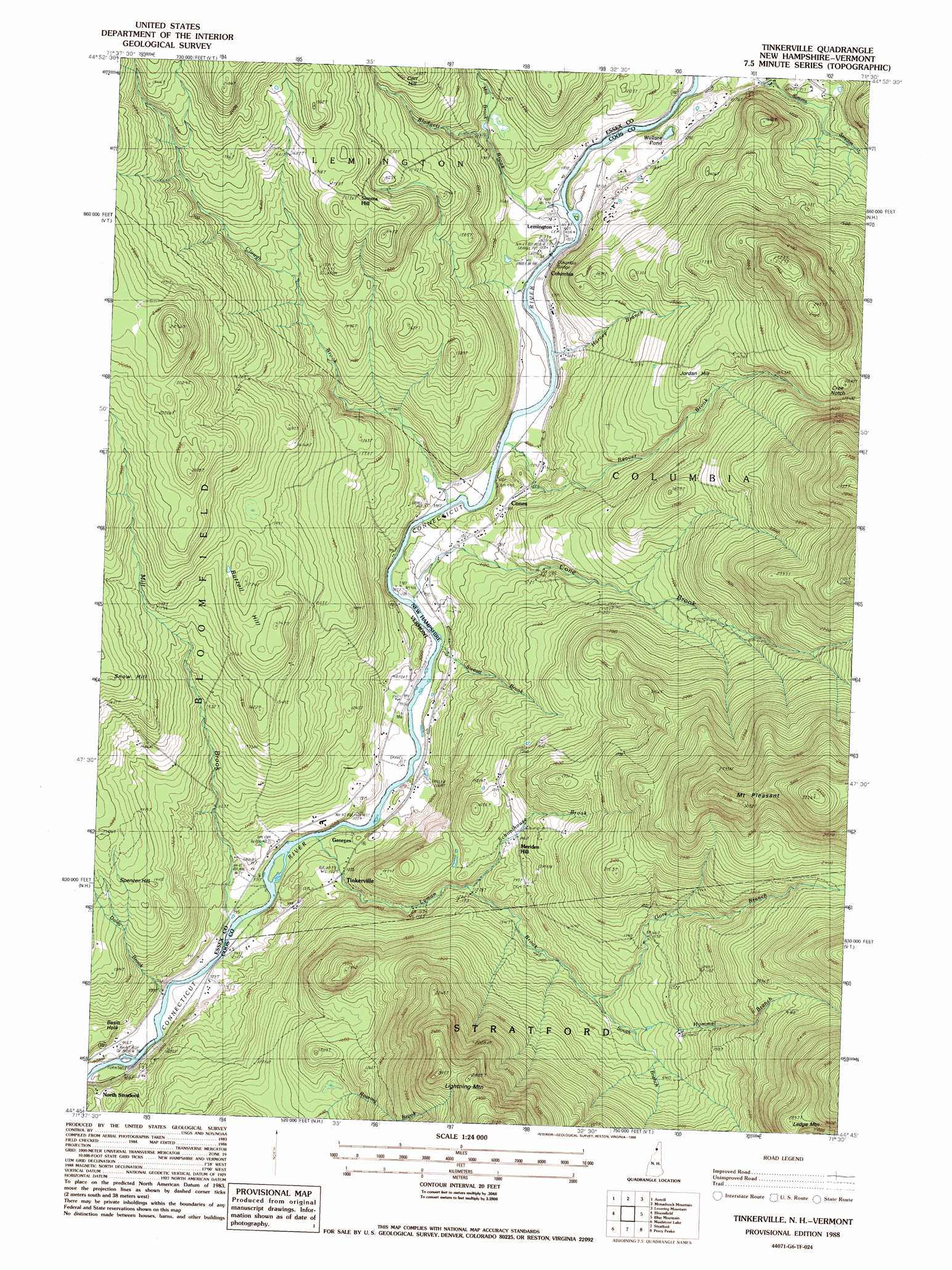
Tinkerville Topo Map New Hampshire
To zoom in, hover over the map of Tinkerville
USGS Topo Quad 44071g5 - 1:24,000 scale
| Topo Map Name: | Tinkerville |
| USGS Topo Quad ID: | 44071g5 |
| Print Size: | ca. 21 1/4" wide x 27" high |
| Southeast Coordinates: | 44.75° N latitude / 71.5° W longitude |
| Map Center Coordinates: | 44.8125° N latitude / 71.5625° W longitude |
| U.S. States: | NH, VT |
| Filename: | o44071g5.jpg |
| Download Map JPG Image: | Tinkerville topo map 1:24,000 scale |
| Map Type: | Topographic |
| Topo Series: | 7.5´ |
| Map Scale: | 1:24,000 |
| Source of Map Images: | United States Geological Survey (USGS) |
| Alternate Map Versions: |
Tinkerville NH 1988, updated 1988 Download PDF Buy paper map Tinkerville NH 1988, updated 1988 Download PDF Buy paper map Tinkerville NH 1988, updated 1988 Download PDF Buy paper map Tinkerville NH 2012 Download PDF Buy paper map Tinkerville NH 2015 Download PDF Buy paper map |
1:24,000 Topo Quads surrounding Tinkerville
Pittsburg |
Lake Francis |
|||
Norton Pond |
Averill Lake |
Monadnock Mountain |
Lovering Mountain |
Diamond Pond |
Spectacle Pond |
Bloomfield |
Tinkerville |
Blue Mountain |
Dixville Notch |
Seneca Mountain |
Maidstone Lake |
Stratford |
Percy Peaks |
Dummer Ponds |
Gallup Mills |
Stone Mountain |
Groveton |
Stark |
West Milan |
> Back to 44071e1 at 1:100,000 scale
> Back to 44070a1 at 1:250,000 scale
> Back to U.S. Topo Maps home
Tinkerville topo map: Gazetteer
Tinkerville: Basins
Basin Hole elevation 314m 1030′Tinkerville: Bridges
Columbia Bridge elevation 300m 984′Columbia Bridge elevation 300m 984′
Tinkerville: Gaps
Cree Notch elevation 576m 1889′Tinkerville: Lakes
Wallace Pond elevation 326m 1069′Tinkerville: Populated Places
Columbia elevation 309m 1013′Cones elevation 316m 1036′
Georges elevation 305m 1000′
Lennington elevation 305m 1000′
Meriden Hill elevation 449m 1473′
Simms Hill elevation 527m 1729′
Tinkerville elevation 310m 1017′
Tinkerville: Streams
Beaver Brook elevation 300m 984′Blodgett Brook elevation 303m 994′
Clough Brook elevation 304m 997′
Cone Brook elevation 298m 977′
Daley Brook elevation 302m 990′
Gore Branch elevation 449m 1473′
Harvey Brook elevation 301m 987′
Hymmel Branch elevation 475m 1558′
Lyman Brook elevation 290m 951′
Mill Brook elevation 286m 938′
Mill Brook elevation 355m 1164′
Schoolhouse Brook elevation 385m 1263′
South Branch Lyman Brook elevation 446m 1463′
Sweatt Brook elevation 295m 967′
Tinkerville: Summits
Buzzell Hill elevation 531m 1742′Jordan Hill elevation 501m 1643′
Ledge Mountain elevation 861m 2824′
Lightning Mountain elevation 809m 2654′
Mount Pleasant elevation 884m 2900′
Simms Hill elevation 550m 1804′
Snow Hill elevation 553m 1814′
Tinkerville digital topo map on disk
Buy this Tinkerville topo map showing relief, roads, GPS coordinates and other geographical features, as a high-resolution digital map file on DVD:
Maine, New Hampshire, Rhode Island & Eastern Massachusetts
Buy digital topo maps: Maine, New Hampshire, Rhode Island & Eastern Massachusetts