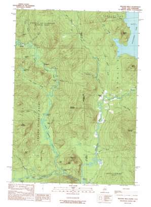
Wilsons Mills Topo Map Maine
To zoom in, hover over the map of Wilsons Mills
USGS Topo Quad 44071h1 - 1:24,000 scale
| Topo Map Name: | Wilsons Mills |
| USGS Topo Quad ID: | 44071h1 |
| Print Size: | ca. 21 1/4" wide x 27" high |
| Southeast Coordinates: | 44.875° N latitude / 71° W longitude |
| Map Center Coordinates: | 44.9375° N latitude / 71.0625° W longitude |
| U.S. States: | ME, NH |
| Filename: | o44071h1.jpg |
| Download Map JPG Image: | Wilsons Mills topo map 1:24,000 scale |
| Map Type: | Topographic |
| Topo Series: | 7.5´ |
| Map Scale: | 1:24,000 |
| Source of Map Images: | United States Geological Survey (USGS) |
| Alternate Map Versions: |
Wilsons Mills ME 1977, updated 1983 Download PDF Buy paper map Willsons Mills ME 1989, updated 1989 Download PDF Buy paper map Wilsons Mills ME 1989, updated 1989 Download PDF Buy paper map Wilsons Mills ME 2011 Download PDF Buy paper map Wilsons Mills ME 2014 Download PDF Buy paper map |
1:24,000 Topo Quads surrounding Wilsons Mills
> Back to 44071e1 at 1:100,000 scale
> Back to 44070a1 at 1:250,000 scale
> Back to U.S. Topo Maps home
Wilsons Mills topo map: Gazetteer
Wilsons Mills: Airports
Miller-Quinn Landing Strip elevation 386m 1266′Wilsons Mills: Bends
Monahans Bathtub elevation 415m 1361′Wilsons Mills: Bridges
Bennett Bridge elevation 383m 1256′Wilsons Mills: Cliffs
Alice Ledge elevation 463m 1519′Finnsons Cliff elevation 528m 1732′
Linda Ledge elevation 505m 1656′
Wilsons Mills: Dams
Abbott Brook Dike elevation 463m 1519′Wilsons Mills: Lakes
Hell Gate Pond elevation 474m 1555′Lamb Valley Pond elevation 478m 1568′
Wilsons Mills: Populated Places
The Hand elevation 448m 1469′Wilsons Mills elevation 395m 1295′
Wilsons Mills: Post Offices
Wilsons Mills Post Office elevation 394m 1292′Wilsons Mills: Ridges
Windey Ridge elevation 545m 1788′Wilsons Mills: Springs
Dart Wentworth Spring elevation 421m 1381′Wilsons Mills: Streams
Abbott Brook elevation 384m 1259′Abbott Brook elevation 384m 1259′
Alder Brook elevation 432m 1417′
Bennett Brook elevation 383m 1256′
Bennett Brook elevation 433m 1420′
Bennett Brook elevation 382m 1253′
Bog Brook elevation 462m 1515′
Clark Brook elevation 393m 1289′
Cold Brook elevation 463m 1519′
Dead Diamond River elevation 382m 1253′
East Horne Brook elevation 420m 1377′
Horne Brook elevation 420m 1377′
Lamb Valley Brook elevation 414m 1358′
Little Abbott Brook elevation 387m 1269′
Little Dead Diamond River elevation 426m 1397′
Loomis Valley Brook elevation 411m 1348′
Meadow Brook elevation 384m 1259′
Merrill Brook elevation 411m 1348′
Sanderson Brook elevation 426m 1397′
Sanderson Brook elevation 433m 1420′
Swift Diamond River elevation 404m 1325′
Washburn Brook elevation 419m 1374′
West Branch Abbott Brook elevation 488m 1601′
Wilsons Mills: Summits
Aziscohos Mountain elevation 963m 3159′Black Mountain elevation 762m 2500′
Diamond Peaks elevation 615m 2017′
Emerys Misery elevation 633m 2076′
Halfmoon Mountain elevation 769m 2522′
Parker Hill elevation 683m 2240′
Rands Rock elevation 627m 2057′
Sams Lookout elevation 439m 1440′
Wilsons Mills digital topo map on disk
Buy this Wilsons Mills topo map showing relief, roads, GPS coordinates and other geographical features, as a high-resolution digital map file on DVD:
Maine, New Hampshire, Rhode Island & Eastern Massachusetts
Buy digital topo maps: Maine, New Hampshire, Rhode Island & Eastern Massachusetts


