Montpelier Topo Map Vermont
To zoom in, hover over the map of Montpelier
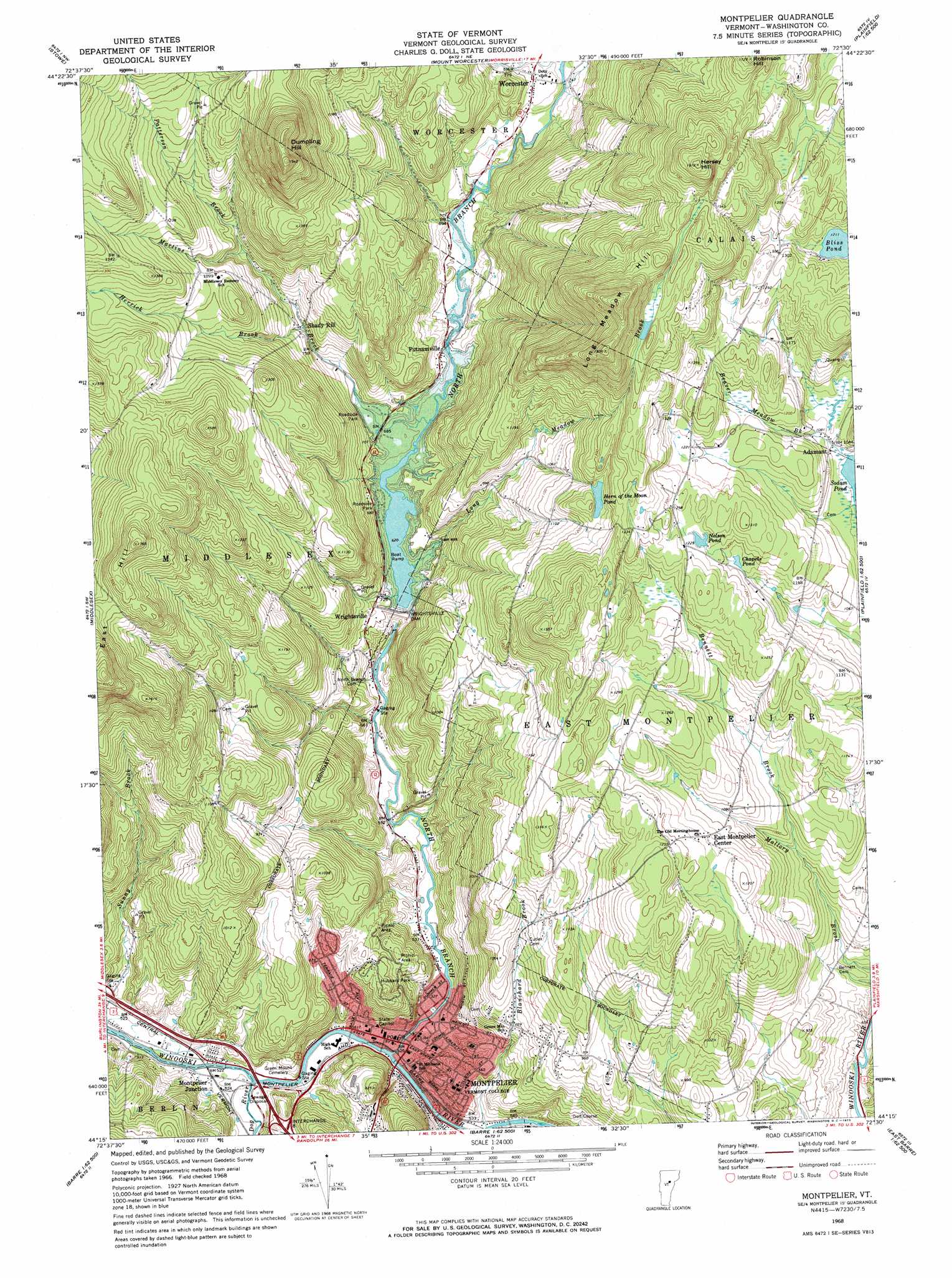
USGS Topo Quad 44072c5 - 1:24,000 scale
| Topo Map Name: | Montpelier |
| USGS Topo Quad ID: | 44072c5 |
| Print Size: | ca. 21 1/4" wide x 27" high |
| Southeast Coordinates: | 44.25° N latitude / 72.5° W longitude |
| Map Center Coordinates: | 44.3125° N latitude / 72.5625° W longitude |
| U.S. State: | VT |
| Filename: | o44072c5.jpg |
| Download Map JPG Image: | Montpelier topo map 1:24,000 scale |
| Map Type: | Topographic |
| Topo Series: | 7.5´ |
| Map Scale: | 1:24,000 |
| Source of Map Images: | United States Geological Survey (USGS) |
| Alternate Map Versions: |
Montpelier VT 1968, updated 1973 Download PDF Buy paper map Montpelier VT 1968, updated 1973 Download PDF Buy paper map Montpelier VT 1999, updated 2000 Download PDF Buy paper map Montpelier VT 2012 Download PDF Buy paper map Montpelier VT 2015 Download PDF Buy paper map |
1:24,000 Topo Quads surrounding Montpelier
Mount Mansfield |
Whiteface Mountain |
Morrisville |
W0Lcott |
Caspian Lake |
Bolton Mountain |
Stowe |
Mount Worcester |
Woodbury |
Cabot |
Waterbury |
Middlesex |
Montpelier |
Plainfield |
Marshfield |
Waitsfield |
Northfield |
Barre West |
Barre East |
Knox Mountain |
Warren |
Roxbury |
Brookfield |
Washington |
West Topsham |
> Back to 44072a1 at 1:100,000 scale
> Back to 44072a1 at 1:250,000 scale
> Back to U.S. Topo Maps home
Montpelier topo map: Gazetteer
Montpelier: Crossings
Interchange 8 elevation 188m 616′Montpelier: Dams
Adamant Pond Dam elevation 329m 1079′Lane Dam elevation 158m 518′
Wrightsville Dam elevation 216m 708′
Montpelier: Forests
East Montpelier Municipal Forest elevation 374m 1227′Montpelier: Lakes
Bliss Pond elevation 369m 1210′Chapels Pond elevation 357m 1171′
Horn of the Moon Pond elevation 374m 1227′
Nelson Pond elevation 372m 1220′
Montpelier: Parks
Hubbard Park elevation 225m 738′Montpelier Historic District elevation 162m 531′
Montpelier Recreational Field elevation 162m 531′
Montpelier: Populated Places
Adamant elevation 321m 1053′East Montpelier Center elevation 350m 1148′
Montpelier elevation 160m 524′
Montpelier Junction elevation 158m 518′
Putnamville elevation 207m 679′
Shady Rill elevation 241m 790′
Worcester elevation 232m 761′
Wrightsville elevation 219m 718′
Montpelier: Post Offices
Montpelier Post Office elevation 162m 531′Montpelier: Reservoirs
Adamant Pond elevation 329m 1079′Wrightsville Reservoir elevation 216m 708′
Montpelier: Streams
Beaver Meadow Brook elevation 315m 1033′Bennett Brook elevation 285m 935′
Blanchard Brook elevation 161m 528′
Dog River elevation 156m 511′
Herrick Brook elevation 237m 777′
Long Meadow Brook elevation 193m 633′
Martins Brook elevation 190m 623′
North Branch Winooski River elevation 158m 518′
Patterson Brook elevation 276m 905′
Montpelier: Summits
Dewey Hill elevation 251m 823′Dumpling Hill elevation 584m 1916′
East Hill elevation 573m 1879′
Hersey Hill elevation 580m 1902′
Long Meadow Hill elevation 607m 1991′
Robinson Hill elevation 518m 1699′
Montpelier digital topo map on disk
Buy this Montpelier topo map showing relief, roads, GPS coordinates and other geographical features, as a high-resolution digital map file on DVD:
New York, Vermont, Connecticut & Western Massachusetts
Buy digital topo maps: New York, Vermont, Connecticut & Western Massachusetts