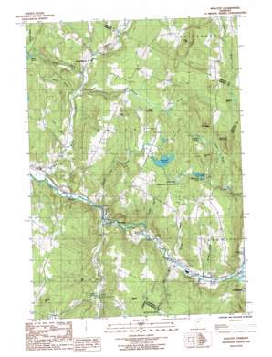
W0Lcott Topo Map Vermont
To zoom in, hover over the map of W0Lcott
USGS Topo Quad 44072e4 - 1:24,000 scale
| Topo Map Name: | W0Lcott |
| USGS Topo Quad ID: | 44072e4 |
| Print Size: | ca. 21 1/4" wide x 27" high |
| Southeast Coordinates: | 44.5° N latitude / 72.375° W longitude |
| Map Center Coordinates: | 44.5625° N latitude / 72.4375° W longitude |
| U.S. State: | VT |
| Filename: | o44072e4.jpg |
| Download Map JPG Image: | W0Lcott topo map 1:24,000 scale |
| Map Type: | Topographic |
| Topo Series: | 7.5´ |
| Map Scale: | 1:24,000 |
| Source of Map Images: | United States Geological Survey (USGS) |
| Alternate Map Versions: |
Wolcott VT 1986, updated 1987 Download PDF Buy paper map Wolcott VT 1986, updated 1987 Download PDF Buy paper map Wolcott VT 2012 Download PDF Buy paper map Wolcott VT 2015 Download PDF Buy paper map |
1:24,000 Topo Quads surrounding W0Lcott
> Back to 44072e1 at 1:100,000 scale
> Back to 44072a1 at 1:250,000 scale
> Back to U.S. Topo Maps home
W0Lcott topo map: Gazetteer
W0Lcott: Airports
Taylor Airport elevation 345m 1131′W0Lcott: Benches
The Ledges elevation 499m 1637′W0Lcott: Bridges
Fisher Covered Railroad Bridge elevation 287m 941′Jackson Bridge elevation 246m 807′
W0Lcott: Dams
Hardwick Lake Dam elevation 245m 803′Wolcott Dam elevation 224m 734′
Wolcott Pond Dam elevation 363m 1190′
W0Lcott: Flats
Beaver Meadow elevation 402m 1318′W0Lcott: Lakes
Keeler Pond elevation 423m 1387′Perch Pond elevation 363m 1190′
Wapanacki Lake elevation 388m 1272′
W0Lcott: Parks
East Hill Wildlife Management Area elevation 400m 1312′W0Lcott: Populated Places
North Wolcott elevation 258m 846′Pottersville elevation 223m 731′
Wolcott elevation 212m 695′
W0Lcott: Post Offices
Wolcott Post Office elevation 222m 728′W0Lcott: Reservoirs
Hardwick Lake elevation 245m 803′Lamoille River Reservoir elevation 224m 734′
Wolcott Pond elevation 363m 1190′
W0Lcott: Streams
Baldin Brook elevation 253m 830′Bruce Brook elevation 233m 764′
Bunker Brook elevation 237m 777′
Clark Brook elevation 229m 751′
Currier Brook elevation 236m 774′
Elmore Branch elevation 207m 679′
Kate Brook elevation 232m 761′
Keeler Brook elevation 339m 1112′
Millard Brook elevation 251m 823′
Tamarack Brook elevation 239m 784′
Wild Branch elevation 204m 669′
Wolcott Pond Brook elevation 211m 692′
W0Lcott: Summits
Brown Hill elevation 429m 1407′Elmore Hill elevation 482m 1581′
Jeudevine Mountain elevation 565m 1853′
Scribner Hill elevation 506m 1660′
Town Hill elevation 442m 1450′
West Hill elevation 550m 1804′
W0Lcott: Swamps
Bear Swamp elevation 336m 1102′W0Lcott digital topo map on disk
Buy this W0Lcott topo map showing relief, roads, GPS coordinates and other geographical features, as a high-resolution digital map file on DVD:
New York, Vermont, Connecticut & Western Massachusetts
Buy digital topo maps: New York, Vermont, Connecticut & Western Massachusetts


