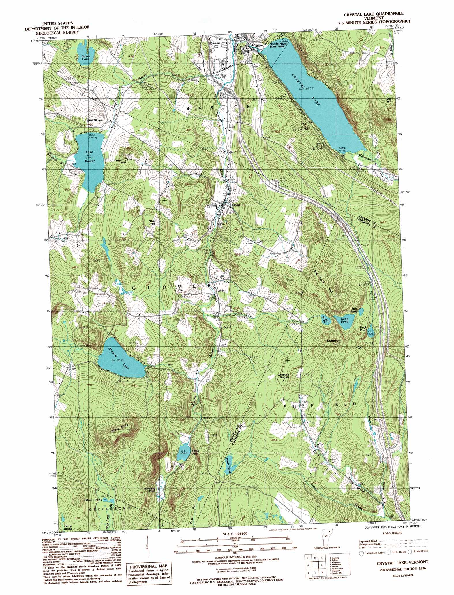
Crystal Lake Topo Map Vermont
To zoom in, hover over the map of Crystal Lake
USGS Topo Quad 44072f2 - 1:24,000 scale
| Topo Map Name: | Crystal Lake |
| USGS Topo Quad ID: | 44072f2 |
| Print Size: | ca. 21 1/4" wide x 27" high |
| Southeast Coordinates: | 44.625° N latitude / 72.125° W longitude |
| Map Center Coordinates: | 44.6875° N latitude / 72.1875° W longitude |
| U.S. State: | VT |
| Filename: | o44072f2.jpg |
| Download Map JPG Image: | Crystal Lake topo map 1:24,000 scale |
| Map Type: | Topographic |
| Topo Series: | 7.5´ |
| Map Scale: | 1:24,000 |
| Source of Map Images: | United States Geological Survey (USGS) |
| Alternate Map Versions: |
Crystal Lake VT 1986, updated 1987 Download PDF Buy paper map Crystal Lake VT 1986, updated 1987 Download PDF Buy paper map Crystal Lake VT 2012 Download PDF Buy paper map Crystal Lake VT 2015 Download PDF Buy paper map |
1:24,000 Topo Quads surrounding Crystal Lake
North Troy |
Newport Center |
Newport |
West Charleston |
Morgan Center |
Lowell |
Irasburg |
Orleans |
Westmore |
Island Pond |
Albany |
Craftsbury |
Crystal Lake |
Sutton |
West Burke |
W0Lcott |
Caspian Lake |
Stannard |
Lyndonville |
Burke Mountain |
Woodbury |
Cabot |
Saint Johnsbury |
Concord |
> Back to 44072e1 at 1:100,000 scale
> Back to 44072a1 at 1:250,000 scale
> Back to U.S. Topo Maps home
Crystal Lake topo map: Gazetteer
Crystal Lake: Crossings
Interchange 25 elevation 268m 879′Crystal Lake: Dams
Crystal Lake Dam elevation 295m 967′Shadow Lake Dam elevation 425m 1394′
Crystal Lake: Lakes
Baker Pond elevation 351m 1151′Bruce Pond elevation 471m 1545′
Clarks Pond elevation 376m 1233′
Crystal Lake elevation 295m 967′
Duck Pond elevation 525m 1722′
Lake Parker elevation 397m 1302′
Long Pond elevation 513m 1683′
Mud Pond elevation 443m 1453′
Mud Pond elevation 522m 1712′
Round Pond elevation 523m 1715′
Runaway Pond elevation 393m 1289′
Crystal Lake: Parks
Crystal Lake State Park elevation 293m 961′Roaring Brook Park elevation 263m 862′
Crystal Lake: Populated Places
Barton elevation 292m 958′Glover elevation 527m 1729′
West Glover elevation 401m 1315′
Crystal Lake: Post Offices
Glover Post Office elevation 293m 961′West Glover Post Office elevation 408m 1338′
Crystal Lake: Reservoirs
Shadow Lake elevation 425m 1394′Crystal Lake: Streams
May Pond Brook elevation 307m 1007′Mud Pond Brook elevation 448m 1469′
Nation Brook elevation 341m 1118′
Roaring Brook elevation 268m 879′
Stevens Brook elevation 397m 1302′
Trout Brook elevation 362m 1187′
Willoughby Brook elevation 288m 944′
Crystal Lake: Summits
Big Rock Hill elevation 657m 2155′Black Hills elevation 697m 2286′
Cemetery Hill elevation 335m 1099′
Dexter Hill elevation 491m 1610′
Lone Tree Hill elevation 294m 964′
May Hill elevation 600m 1968′
Sheffield Heights elevation 550m 1804′
Simpson Hill elevation 609m 1998′
Still Hill elevation 516m 1692′
Crystal Lake digital topo map on disk
Buy this Crystal Lake topo map showing relief, roads, GPS coordinates and other geographical features, as a high-resolution digital map file on DVD:
New York, Vermont, Connecticut & Western Massachusetts
Buy digital topo maps: New York, Vermont, Connecticut & Western Massachusetts