Johnson Topo Map Vermont
To zoom in, hover over the map of Johnson
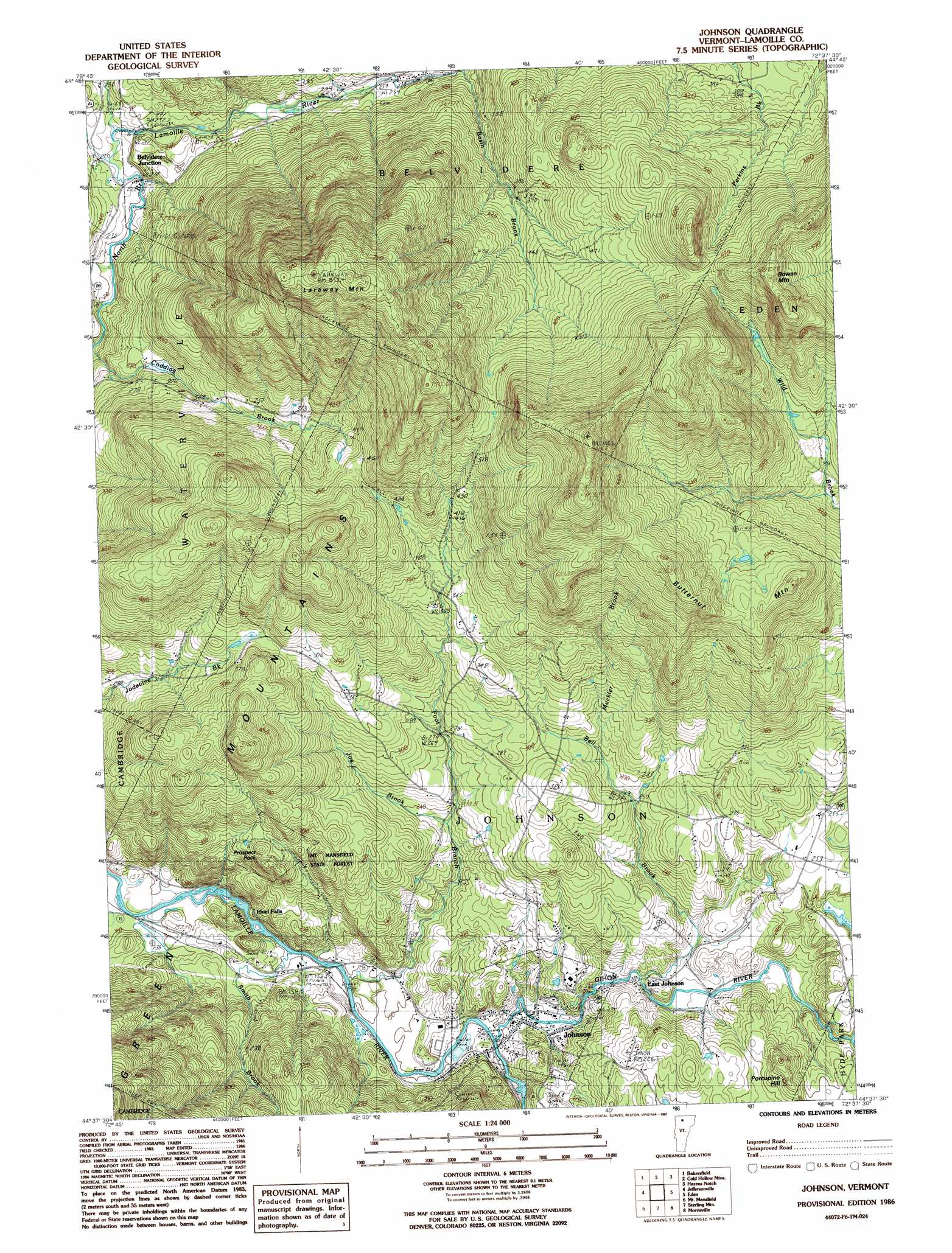
USGS Topo Quad 44072f6 - 1:24,000 scale
| Topo Map Name: | Johnson |
| USGS Topo Quad ID: | 44072f6 |
| Print Size: | ca. 21 1/4" wide x 27" high |
| Southeast Coordinates: | 44.625° N latitude / 72.625° W longitude |
| Map Center Coordinates: | 44.6875° N latitude / 72.6875° W longitude |
| U.S. State: | VT |
| Filename: | o44072f6.jpg |
| Download Map JPG Image: | Johnson topo map 1:24,000 scale |
| Map Type: | Topographic |
| Topo Series: | 7.5´ |
| Map Scale: | 1:24,000 |
| Source of Map Images: | United States Geological Survey (USGS) |
| Alternate Map Versions: |
Johnson VT 1986, updated 1987 Download PDF Buy paper map Johnson VT 1986, updated 1987 Download PDF Buy paper map Johnson VT 2012 Download PDF Buy paper map Johnson VT 2015 Download PDF Buy paper map |
1:24,000 Topo Quads surrounding Johnson
Sheldon Springs |
Enosburg Falls |
Richford |
Jay Peak |
North Troy |
Fairfield |
Bakersfield |
Cold Hollow Mountains |
Hazens Notch |
Lowell |
Gilson Mountain |
Jeffersonville |
Johnson |
Eden |
Albany |
Underhill |
Mount Mansfield |
Whiteface Mountain |
Morrisville |
W0Lcott |
Richmond |
Bolton Mountain |
Stowe |
Mount Worcester |
Woodbury |
> Back to 44072e1 at 1:100,000 scale
> Back to 44072a1 at 1:250,000 scale
> Back to U.S. Topo Maps home
Johnson topo map: Gazetteer
Johnson: Bridges
Mill Covered Bridge elevation 223m 731′Morgan Covered Bridge elevation 228m 748′
Power House Covered Bridge elevation 168m 551′
Scribner Covered Bridge elevation 186m 610′
Johnson: Dams
Hyde Park Dam elevation 227m 744′Johnson: Populated Places
Belvidere Junction elevation 217m 711′East Johnson elevation 177m 580′
Ithiel Falls elevation 168m 551′
Johnson elevation 153m 501′
Johnson: Post Offices
Johnson Post Office elevation 150m 492′Johnson: Streams
Basin Brook elevation 290m 951′Bell Brook elevation 189m 620′
Foot Brook elevation 141m 462′
Gihon River elevation 148m 485′
Joe Brook elevation 226m 741′
Muckler Brook elevation 266m 872′
North Fork North Branch Lamoille River elevation 245m 803′
Smith Brook elevation 143m 469′
Streeter Brook elevation 215m 705′
Johnson: Summits
Bowen Mountain elevation 686m 2250′Butternut Mountain elevation 660m 2165′
Laraway Mountain elevation 830m 2723′
Prospect Rock elevation 311m 1020′
Johnson digital topo map on disk
Buy this Johnson topo map showing relief, roads, GPS coordinates and other geographical features, as a high-resolution digital map file on DVD:
New York, Vermont, Connecticut & Western Massachusetts
Buy digital topo maps: New York, Vermont, Connecticut & Western Massachusetts